Bufali elevation
Bufali (Valencia, Província de València), Spain elevation is 237 meters and Bufali elevation in feet is 778 ft above sea level [src 1]. Bufali is a seat of a third-order administrative division (feature code) with elevation that is 366 meters (1201 ft) smaller than average city elevation in Spain.
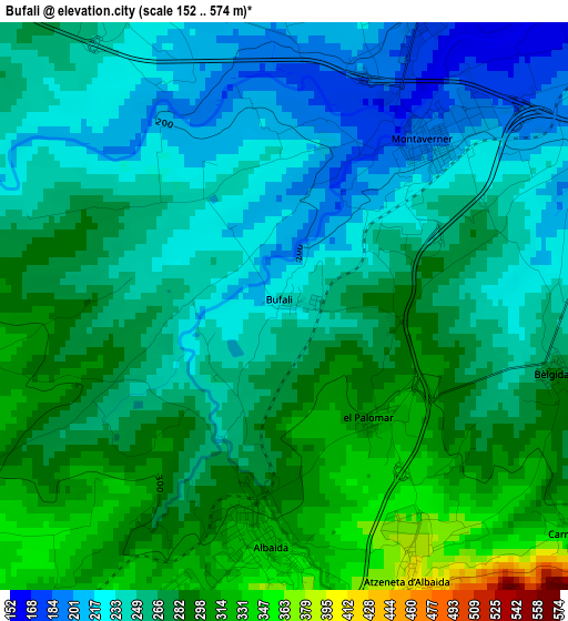
Below is the Elevation map of Bufali, which displays elevation range with different colors. Scale of the first map is from 152 to 574 m (499 to 1883 ft) with average elevation of 263.1 meters (=863 ft) [note 1]
These maps also provides idea of topography and contour of this city, they are displayed at different zoom levels. More info about maps, scale and edge coordinates you can find below images.
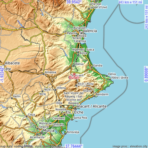
| \ | Map #1 | Topo.Map |
| Scale [m] | 152..574 m | × |
| Scale [ft] | 499..1883 ft | × |
| Average | 263.1 m = 863 ft | × |
| Width | 7.61 km = 4.7 mi | 243.5 km = 151.3 mi |
| Height | 7.61 km = 4.7 mi | 243.5 km = 151.3 mi |
| ↑Max Latitude | 38.901957° | 39.9542° |
| Latitude at center | 38.86775° | 38.86775° |
| ↓Min Latitude | 38.833526° | 37.76444° |
| ← Min Longitude | -0.560115° | -1.92242° |
| Longitude center | -0.51617° | -0.51617° |
| →Max Longitude | -0.472225° | 0.89008° |
Nearby cities:
Cities around Bufali sort by population:
• L'Olleria elevation 255 m
6.2 km,  331°
331°
• Albaida 328 m
3.3 km,  181°
181°
• Aielo de Malferit 269 m
6.1 km,  286°
286°
• Agullent 410 m
5.7 km,  209°
209°
• Montaberner 184 m
3.1 km,  35°
35°
• Atzeneta d'Albaida 384 m
4.1 km,  159°
159°
• Alfarrasí 193 m
3.8 km,  21°
21°
• Bèlgida 275 m
4.7 km,  114°
114°
• Otos 331 m
6.4 km,  103°
103°
• Benissoda 366 m
3.8 km, 180°
• Benisuera 169 m
6 km,  33°
33°
• Carrícola 328 m
4.8 km,  127°
127°
Multilingual:
 En español:
Bufali elevación 237 m.
 En France:
Bufali élévation 237 m.


Sources and notes:
- [note 1] Map square and city borders are not equal. Map elevation data is calculated only from area inside that square.
- [src 1] Elevation data from geonames database provided with same terms of usage.
- [src 2] The elevation map of Bufali is generated using elevation data from NASA's 3 arcsec (90m) resolution SRTM data.
- [src 3] Base (background) map © OpenStreetMap contributors tiles are generated by Geofabrik and OpenTopoMap.
Copyright & License:
This Bufali Elevation Map is licensed under CC BY-SA. You may reuse any part from this page, if you give a proper credit by linking to this URL:
 More info on terms of use page.