Canjáyar elevation
Canjáyar (Andalusia, Almería), Spain elevation is 604 meters and Canjáyar elevation in feet is 1982 ft above sea level [src 1]. Canjáyar is a seat of a third-order administrative division (feature code) with elevation that is 1 meters (3 ft) bigger than average city elevation in Spain.
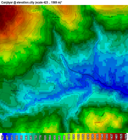
Below is the Elevation map of Canjáyar, which displays elevation range with different colors. Scale of the first map is from 423 to 1569 m (1388 to 5148 ft) with average elevation of 813.6 meters (=2669 ft) [note 1]
These maps also provides idea of topography and contour of this city, they are displayed at different zoom levels. More info about maps, scale and edge coordinates you can find below images.
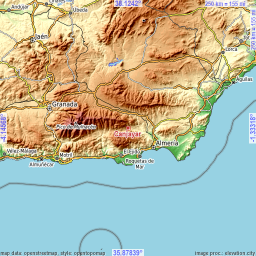
| \ | Map #1 | Topo.Map |
| Scale [m] | 423..1569 m | × |
| Scale [ft] | 1388..5148 ft | × |
| Average | 813.6 m = 2669 ft | × |
| Width | 7.8 km = 4.8 mi | 249.7 km = 155.2 mi |
| Height | 7.8 km = 4.8 mi | 249.7 km = 155.2 mi |
| ↑Max Latitude | 37.044674° | 38.1242° |
| Latitude at center | 37.00959° | 37.00959° |
| ↓Min Latitude | 36.97449° | 35.87839° |
| ← Min Longitude | -2.783375° | -4.14568° |
| Longitude center | -2.73943° | -2.73943° |
| →Max Longitude | -2.695485° | -1.33318° |
Nearby cities:
Cities around Canjáyar sort by population:
• Fondón elevation 851 m
11.2 km,  252°
252°
• Ohanes 977 m
3.3 km,  350°
350°
• Huécija 411 m
12.4 km,  111°
111°
• Instinción 429 m
7.2 km,  104°
104°
• Padules 748 m
3.3 km, 247°
• Terque 293 m
13 km, 102°
• Illar 417 m
9.3 km, 106°
• Rágol 413 m
5.4 km, 107°
• Bentarique 326 m
10.9 km, 102°
• Almócita 832 m
4.6 km,  260°
260°
• Alsodux 310 m
12.9 km,  93°
93°
• Beires 932 m
4.6 km,  273°
273°
Multilingual:
 En español:
Canjáyar elevación 604 m.
 En France:
Canjáyar élévation 604 m.
 Auf Deutsch:
Canjáyar höhe über dem Meeresspiegel ist 604 m.

Sources and notes:
- [note 1] Map square and city borders are not equal. Map elevation data is calculated only from area inside that square.
- [src 1] Elevation data from geonames database provided with same terms of usage.
- [src 2] The elevation map of Canjáyar is generated using elevation data from NASA's 3 arcsec (90m) resolution SRTM data.
- [src 3] Base (background) map © OpenStreetMap contributors tiles are generated by Geofabrik and OpenTopoMap.
Copyright & License:
This Canjáyar Elevation Map is licensed under CC BY-SA. You may reuse any part from this page, if you give a proper credit by linking to this URL:
 More info on terms of use page.