Capilla elevation
Capilla (Extremadura, Provincia de Badajoz), Spain elevation is 487 meters and Capilla elevation in feet is 1598 ft above sea level [src 1]. Capilla is a seat of a third-order administrative division (feature code) with elevation that is 116 meters (381 ft) smaller than average city elevation in Spain.
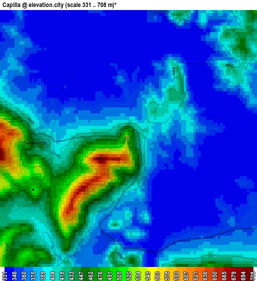
Below is the Elevation map of Capilla, which displays elevation range with different colors. Scale of the first map is from 331 to 708 m (1086 to 2323 ft) with average elevation of 390.4 meters (=1281 ft) [note 1]
These maps also provides idea of topography and contour of this city, they are displayed at different zoom levels. More info about maps, scale and edge coordinates you can find below images.
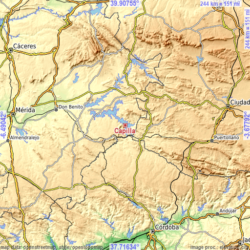
| \ | Map #1 | Topo.Map |
| Scale [m] | 331..708 m | × |
| Scale [ft] | 1086..2323 ft | × |
| Average | 390.4 m = 1281 ft | × |
| Width | 7.61 km = 4.7 mi | 243.6 km = 151.4 mi |
| Height | 7.61 km = 4.7 mi | 243.6 km = 151.4 mi |
| ↑Max Latitude | 38.8546° | 39.90755° |
| Latitude at center | 38.82037° | 38.82037° |
| ↓Min Latitude | 38.786123° | 37.71634° |
| ← Min Longitude | -5.128115° | -6.49042° |
| Longitude center | -5.08417° | -5.08417° |
| →Max Longitude | -5.040225° | -3.67792° |
Nearby cities:
Cities around Capilla sort by population:
• Cabeza del Buey elevation 531 m
16 km,  227°
227°
• Siruela 520 m
17.7 km,  9°
9°
• Peñalsordo 423 m
2.6 km,  269°
269°
• Puebla de Alcocer 502 m
23.7 km,  321°
321°
• Esparragosa de Lares 471 m
23.5 km, 316°
• Garlitos 539 m
7.4 km,  25°
25°
• Baterno 560 m
21.3 km,  44°
44°
• Tamurejo 570 m
22.3 km, 35°
• Agudo 566 m
25.7 km,  45°
45°
• Almadén 567 m
22.5 km,  102°
102°
• Chillón 520 m
19.1 km, 98°
• Guadalmez 364 m
14.3 km,  136°
136°
Multilingual:
 En español:
Capilla elevación 487 m.
 En France:
Capilla élévation 487 m.


Sources and notes:
- [note 1] Map square and city borders are not equal. Map elevation data is calculated only from area inside that square.
- [src 1] Elevation data from geonames database provided with same terms of usage.
- [src 2] The elevation map of Capilla is generated using elevation data from NASA's 3 arcsec (90m) resolution SRTM data.
- [src 3] Base (background) map © OpenStreetMap contributors tiles are generated by Geofabrik and OpenTopoMap.
Copyright & License:
This Capilla Elevation Map is licensed under CC BY-SA. You may reuse any part from this page, if you give a proper credit by linking to this URL:
 More info on terms of use page.