Castuera elevation
Castuera (Extremadura, Provincia de Badajoz), Spain elevation is 470 meters and Castuera elevation in feet is 1542 ft above sea level [src 1]. Castuera is a populated place (feature code) with elevation that is 133 meters (436 ft) smaller than average city elevation in Spain.
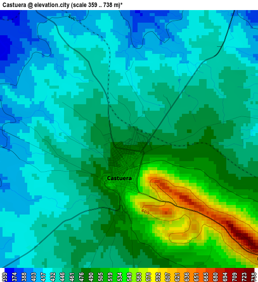
Below is the Elevation map of Castuera, which displays elevation range with different colors. Scale of the first map is from 359 to 738 m (1178 to 2421 ft) with average elevation of 461 meters (=1512 ft) [note 1]
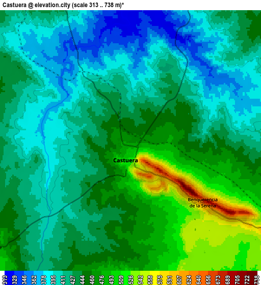
These maps also provides idea of topography and contour of this city, they are displayed at different zoom levels. More info about maps, scale and edge coordinates you can find below images.
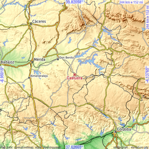
| \ | Map #1 | Map #2 | Topo.Map |
| Scale [m] | 359..738 m | 313..738 m | × |
| Scale [ft] | 1178..2421 ft | 1027..2421 ft | × |
| Average | 461 m = 1512 ft | 436.2 m = 1431 ft | × |
| Width | 7.62 km = 4.7 mi | 15.25 km = 9.5 mi | 243.9 km = 151.6 mi |
| Height | 7.62 km = 4.7 mi | 15.25 km = 9.5 mi | 243.9 km = 151.6 mi |
| ↑Max Latitude | 38.766313° | 38.800569° | 39.82058° |
| Latitude at center | 38.73204° | 38.73204° | 38.73204° |
| ↓Min Latitude | 38.697751° | 38.663445° | 37.62665° |
| ← Min Longitude | -5.587845° | -5.631791° | -6.95015° |
| Longitude center | -5.5439° | -5.5439° | -5.5439° |
| →Max Longitude | -5.499955° | -5.456009° | -4.13765° |
Nearby cities:
Cities around Castuera sort by population:
• Cabeza del Buey elevation 531 m
28.2 km,  92°
92°
• Campanario 397 m
16 km,  336°
336°
• Quintana de la Serena 411 m
11.2 km,  277°
277°
• Zalamea de la Serena 478 m
13.5 km,  228°
228°
• Monterrubio de la Serena 555 m
18.1 km,  151°
151°
• La Coronada 349 m
23.6 km,  332°
332°
• Valle de la Serena 437 m
22.2 km,  263°
263°
• La Haba 313 m
30.4 km,  313°
313°
• Esparragosa de la Serena 448 m
10.5 km,  211°
211°
• Higuera de la Serena 477 m
19.6 km,  240°
240°
• Malpartida de la Serena 481 m
10.5 km, 232°
• Magacela 456 m
24.6 km,  317°
317°
Multilingual:
 En español:
Castuera elevación 470 m.
 En France:
Castuera élévation 470 m.
 Auf Deutsch:
Castuera höhe über dem Meeresspiegel ist 470 m.

Sources and notes:
- [note 1] Map square and city borders are not equal. Map elevation data is calculated only from area inside that square.
- [src 1] Elevation data from geonames database provided with same terms of usage.
- [src 2] The elevation map of Castuera is generated using elevation data from NASA's 3 arcsec (90m) resolution SRTM data.
- [src 3] Base (background) map © OpenStreetMap contributors tiles are generated by Geofabrik and OpenTopoMap.
Copyright & License:
This Castuera Elevation Map is licensed under CC BY-SA. You may reuse any part from this page, if you give a proper credit by linking to this URL:
 More info on terms of use page.