Cenizate elevation
Cenizate (Castille-La Mancha, Provincia de Albacete), Spain elevation is 695 meters and Cenizate elevation in feet is 2280 ft above sea level [src 1]. Cenizate is a seat of a third-order administrative division (feature code) with elevation that is 92 meters (302 ft) bigger than average city elevation in Spain.
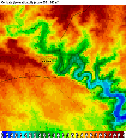
Below is the Elevation map of Cenizate, which displays elevation range with different colors. Scale of the first map is from 655 to 743 m (2149 to 2438 ft) with average elevation of 710.9 meters (=2332 ft) [note 1]
These maps also provides idea of topography and contour of this city, they are displayed at different zoom levels. More info about maps, scale and edge coordinates you can find below images.
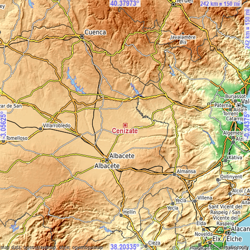
| \ | Map #1 | Topo.Map |
| Scale [m] | 655..743 m | × |
| Scale [ft] | 2149..2438 ft | × |
| Average | 710.9 m = 2332 ft | × |
| Width | 7.56 km = 4.7 mi | 242 km = 150.4 mi |
| Height | 7.56 km = 4.7 mi | 242 km = 150.4 mi |
| ↑Max Latitude | 39.333998° | 40.37973° |
| Latitude at center | 39.3° | 39.3° |
| ↓Min Latitude | 39.265985° | 38.20335° |
| ← Min Longitude | -1.693945° | -3.05625° |
| Longitude center | -1.65° | -1.65° |
| →Max Longitude | -1.606055° | -0.24375° |
Nearby cities:
Cities around Cenizate sort by population:
• Madrigueras elevation 690 m
14.9 km,  240°
240°
• Casas Ibáñez 705 m
15.9 km,  96°
96°
• Iniesta 755 m
17.1 km,  329°
329°
• Villamalea 737 m
9.4 km,  37°
37°
• Fuentealbilla 660 m
9.4 km,  113°
113°
• Ledaña 734 m
8.6 km, 329°
• Mahora 669 m
11.7 km,  217°
217°
• Abengibre 651 m
13.7 km,  132°
132°
• Villagarcía del Llano 719 m
15.9 km,  276°
276°
• Villarta 776 m
16.7 km,  0°
0°
• Navas de Jorquera 709 m
6 km,  252°
252°
• Golosalvo 718 m
7.6 km,  169°
169°
Multilingual:
 En español:
Cenizate elevación 695 m.
 En France:
Cenizate élévation 695 m.
 Auf Deutsch:
Cenizate höhe über dem Meeresspiegel ist 695 m.

Sources and notes:
- [note 1] Map square and city borders are not equal. Map elevation data is calculated only from area inside that square.
- [src 1] Elevation data from geonames database provided with same terms of usage.
- [src 2] The elevation map of Cenizate is generated using elevation data from NASA's 3 arcsec (90m) resolution SRTM data.
- [src 3] Base (background) map © OpenStreetMap contributors tiles are generated by Geofabrik and OpenTopoMap.
Copyright & License:
This Cenizate Elevation Map is licensed under CC BY-SA. You may reuse any part from this page, if you give a proper credit by linking to this URL:
 More info on terms of use page.