Chipiona elevation
Chipiona (Andalusia, Provincia de Cádiz), Spain elevation is 6 meters and Chipiona elevation in feet is 20 ft above sea level [src 1]. Chipiona is a seat of a third-order administrative division (feature code) with elevation that is 597 meters (1959 ft) smaller than average city elevation in Spain.
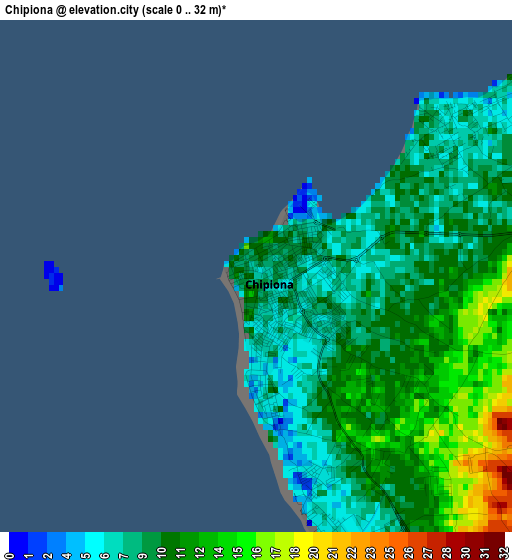
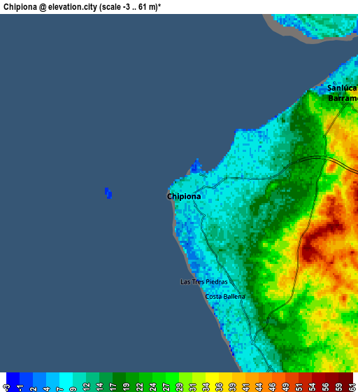
Below is the Elevation map of Chipiona, which displays elevation range with different colors. Scale of the first map is from 0 to 32 m (0 to 105 ft) with average elevation of 10.3 meters (=34 ft) [note 1]
These maps also provides idea of topography and contour of this city, they are displayed at different zoom levels. More info about maps, scale and edge coordinates you can find below images.
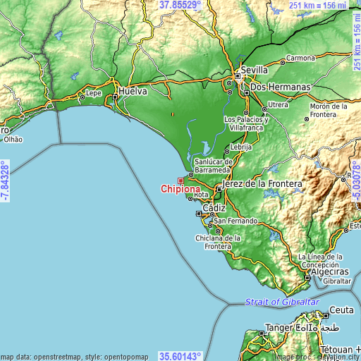
| \ | Map #1 | Map #2 | Topo.Map |
| Scale [m] | 0..32 m | -3..61 m | × |
| Scale [ft] | 0..105 ft | -10..200 ft | × |
| Average | 10.3 m = 34 ft | 21.7 m = 71 ft | × |
| Width | 7.83 km = 4.9 mi | 15.66 km = 9.7 mi | 250.6 km = 155.7 mi |
| Height | 7.83 km = 4.9 mi | 15.66 km = 9.7 mi | 250.6 km = 155.7 mi |
| ↑Max Latitude | 36.771839° | 36.807033° | 37.85529° |
| Latitude at center | 36.73663° | 36.73663° | 36.73663° |
| ↓Min Latitude | 36.701404° | 36.666163° | 35.60143° |
| ← Min Longitude | -6.480975° | -6.524921° | -7.84328° |
| Longitude center | -6.43703° | -6.43703° | -6.43703° |
| →Max Longitude | -6.393085° | -6.349139° | -5.03078° |
Nearby cities:
Cities around Chipiona sort by population:
• Jerez de la Frontera elevation 53 m
27.4 km,  101°
101°
• Cadiz 22 m
26.8 km,  150°
150°
• San Fernando 15 m
36 km,  143°
143°
• El Puerto de Santa María 11 m
24.1 km,  131°
131°
• Chiclana de la Frontera 14 m
43.9 km, 143°
• Sanlúcar de Barrameda 12 m
8.9 km,  58°
58°
• Puerto Real 14 m
32 km, 136°
• Rota 18 m
14 km, 151°
• Lebrija 41 m
38.2 km, 57°
• Las Cabezas de San Juan 46 m
52.1 km, 58°
• El Cuervo 62 m
37.8 km,  69°
69°
• Trebujena 73 m
27.6 km, 57°
Multilingual:
 En español:
Chipiona elevación 6 m.
 En France:
Chipiona élévation 6 m.


Sources and notes:
- [note 1] Map square and city borders are not equal. Map elevation data is calculated only from area inside that square.
- [src 1] Elevation data from geonames database provided with same terms of usage.
- [src 2] The elevation map of Chipiona is generated using elevation data from NASA's 3 arcsec (90m) resolution SRTM data.
- [src 3] Base (background) map © OpenStreetMap contributors tiles are generated by Geofabrik and OpenTopoMap.
Copyright & License:
This Chipiona Elevation Map is licensed under CC BY-SA. You may reuse any part from this page, if you give a proper credit by linking to this URL:
 More info on terms of use page.