Coín elevation
Coín (Andalusia, Provincia de Málaga), Spain elevation is 210 meters and Coín elevation in feet is 689 ft above sea level [src 1]. Coín is a seat of a third-order administrative division (feature code) with elevation that is 393 meters (1289 ft) smaller than average city elevation in Spain.
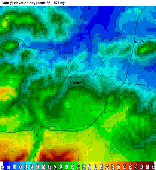
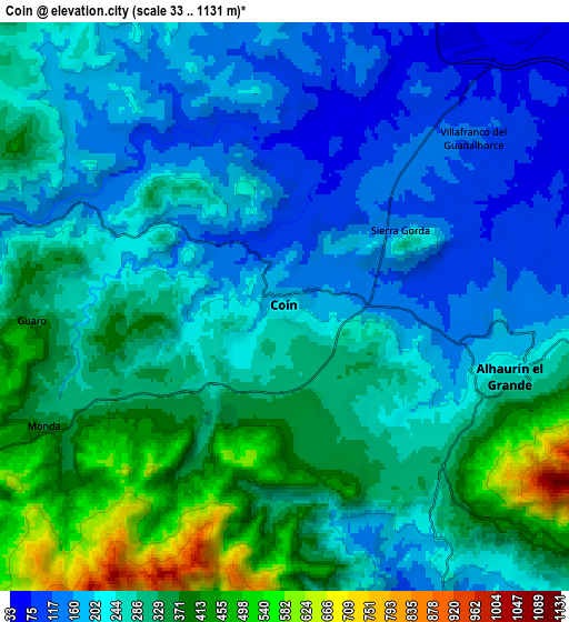
Below is the Elevation map of Coín, which displays elevation range with different colors. Scale of the first map is from 66 to 571 m (217 to 1873 ft) with average elevation of 226.1 meters (=742 ft) [note 1]
These maps also provides idea of topography and contour of this city, they are displayed at different zoom levels. More info about maps, scale and edge coordinates you can find below images.
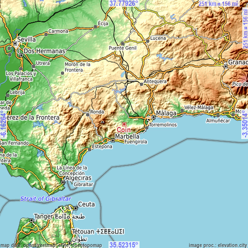
| \ | Map #1 | Map #2 | Topo.Map |
| Scale [m] | 66..571 m | 33..1131 m | × |
| Scale [ft] | 217..1873 ft | 108..3711 ft | × |
| Average | 226.1 m = 742 ft | 269.8 m = 885 ft | × |
| Width | 7.84 km = 4.9 mi | 15.68 km = 9.7 mi | 250.9 km = 155.9 mi |
| Height | 7.84 km = 4.9 mi | 15.68 km = 9.7 mi | 250.9 km = 155.9 mi |
| ↑Max Latitude | 36.694715° | 36.729943° | 37.77926° |
| Latitude at center | 36.65947° | 36.65947° | 36.65947° |
| ↓Min Latitude | 36.624209° | 36.588932° | 35.52315° |
| ← Min Longitude | -4.800335° | -4.844281° | -6.16264° |
| Longitude center | -4.75639° | -4.75639° | -4.75639° |
| →Max Longitude | -4.712445° | -4.668499° | -3.35014° |
Nearby cities:
Cities around Coín sort by population:
• Mijas elevation 418 m
12.8 km,  123°
123°
• Alhaurín el Grande 249 m
6.4 km,  106°
106°
• Cártama 89 m
12.4 km,  62°
62°
• Pizarra 78 m
12.5 km,  19°
19°
• Estación de Cártama 40 m
14.9 km, 56°
• Yunquera 682 m
16.8 km,  298°
298°
• Casarabonela 480 m
16.1 km,  331°
331°
• Ojén 330 m
13.8 km,  220°
220°
• Tolox 313 m
13.6 km,  283°
283°
• Alozaina 380 m
11.8 km,  309°
309°
• Monda 365 m
7.5 km,  244°
244°
• Guaro 343 m
7 km,  267°
267°
Multilingual:
 En español:
Coín elevación 210 m.
 En France:
Coín élévation 210 m.


Sources and notes:
- [note 1] Map square and city borders are not equal. Map elevation data is calculated only from area inside that square.
- [src 1] Elevation data from geonames database provided with same terms of usage.
- [src 2] The elevation map of Coín is generated using elevation data from NASA's 3 arcsec (90m) resolution SRTM data.
- [src 3] Base (background) map © OpenStreetMap contributors tiles are generated by Geofabrik and OpenTopoMap.
Copyright & License:
This Coín Elevation Map is licensed under CC BY-SA. You may reuse any part from this page, if you give a proper credit by linking to this URL:
 More info on terms of use page.