Cullera elevation
Cullera (Valencia, Província de València), Spain elevation is 117 meters and Cullera elevation in feet is 384 ft above sea level [src 1]. Cullera is a seat of a third-order administrative division (feature code) with elevation that is 486 meters (1594 ft) smaller than average city elevation in Spain.
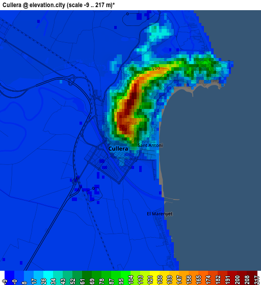
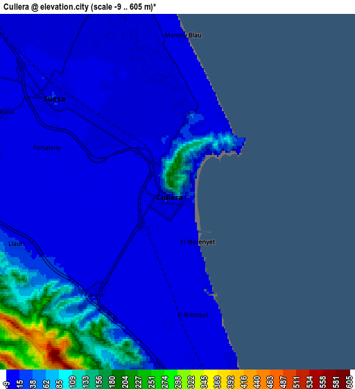
Below is the Elevation map of Cullera, which displays elevation range with different colors. Scale of the first map is from -9 to 217 m (-30 to 712 ft) with average elevation of 11.6 meters (=38 ft) [note 1]
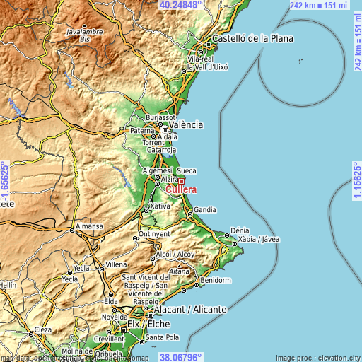
These maps also provides idea of topography and contour of this city, they are displayed at different zoom levels. More info about maps, scale and edge coordinates you can find below images.
| \ | Map #1 | Map #2 | Topo.Map |
| Scale [m] | -9..217 m | -9..605 m | × |
| Scale [ft] | -30..712 ft | -30..1985 ft | × |
| Average | 11.6 m = 38 ft | 35.7 m = 117 ft | × |
| Width | 7.58 km = 4.7 mi | 15.15 km = 9.4 mi | 242.5 km = 150.7 mi |
| Height | 7.58 km = 4.7 mi | 15.15 km = 9.4 mi | 242.4 km = 150.6 mi |
| ↑Max Latitude | 39.200733° | 39.23478° | 40.24848° |
| Latitude at center | 39.16667° | 39.16667° | 39.16667° |
| ↓Min Latitude | 39.13259° | 39.098494° | 38.06796° |
| ← Min Longitude | -0.293945° | -0.337891° | -1.65625° |
| Longitude center | -0.25° | -0.25° | -0.25° |
| →Max Longitude | -0.206055° | -0.162109° | 1.15625° |
Nearby cities:
Cities around Cullera sort by population:
• Sueca elevation 14 m
6.6 km,  307°
307°
• Tavernes de la Valldigna 20 m
10.6 km,  187°
187°
• Xeraco,Jaraco 14 m
15.1 km,  169°
169°
• Albalat de la Ribera 16 m
12.1 km,  287°
287°
• Simat de la Valldigna 449 m
15.9 km,  201°
201°
• Corbera 43 m
8.8 km,  257°
257°
• El Perelló 5 m
12.5 km,  349°
349°
• Polinyà de Xúquer 11 m
10.7 km, 290°
• Favara 39 m
6.3 km,  207°
207°
• Riola 10 m
8.1 km,  297°
297°
• Llaurí 19 m
7.2 km,  252°
252°
• Fortaleny 6 m
4.7 km, 293°
Multilingual:
 En español:
Cullera elevación 117 m.
 En France:
Cullera élévation 117 m.


Sources and notes:
- [note 1] Map square and city borders are not equal. Map elevation data is calculated only from area inside that square.
- [src 1] Elevation data from geonames database provided with same terms of usage.
- [src 2] The elevation map of Cullera is generated using elevation data from NASA's 3 arcsec (90m) resolution SRTM data.
- [src 3] Base (background) map © OpenStreetMap contributors tiles are generated by Geofabrik and OpenTopoMap.
Copyright & License:
This Cullera Elevation Map is licensed under CC BY-SA. You may reuse any part from this page, if you give a proper credit by linking to this URL:
 More info on terms of use page.