Dos Torres elevation
Dos Torres (Andalusia, Province of Córdoba), Spain elevation is 599 meters and Dos Torres elevation in feet is 1965 ft above sea level [src 1]. Dos Torres is a seat of a third-order administrative division (feature code) with elevation that is 4 meters (13 ft) smaller than average city elevation in Spain.
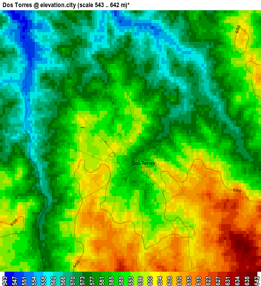
Below is the Elevation map of Dos Torres, which displays elevation range with different colors. Scale of the first map is from 543 to 642 m (1781 to 2106 ft) with average elevation of 586.5 meters (=1924 ft) [note 1]
These maps also provides idea of topography and contour of this city, they are displayed at different zoom levels. More info about maps, scale and edge coordinates you can find below images.
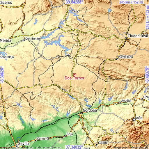
| \ | Map #1 | Topo.Map |
| Scale [m] | 543..642 m | × |
| Scale [ft] | 1781..2106 ft | × |
| Average | 586.5 m = 1924 ft | × |
| Width | 7.65 km = 4.8 mi | 244.9 km = 152.2 mi |
| Height | 7.65 km = 4.8 mi | 244.9 km = 152.2 mi |
| ↑Max Latitude | 38.484408° | 39.54288° |
| Latitude at center | 38.45° | 38.45° |
| ↓Min Latitude | 38.415576° | 37.34032° |
| ← Min Longitude | -4.943945° | -6.30625° |
| Longitude center | -4.9° | -4.9° |
| →Max Longitude | -4.856055° | -3.49375° |
Nearby cities:
Cities around Dos Torres sort by population:
• Pozoblanco elevation 657 m
9.1 km,  150°
150°
• Hinojosa del Duque 551 m
22.2 km,  284°
284°
• El Viso 565 m
5.7 km,  310°
310°
• Pedroche 628 m
12.1 km,  101°
101°
• Villanueva del Duque 588 m
11.4 km,  229°
229°
• Añora 621 m
3.7 km,  180°
180°
• Alcaracejos 622 m
9.4 km,  218°
218°
• Villaralto 577 m
7.3 km,  270°
270°
• Torrecampo 601 m
20.4 km,  84°
84°
• Santa Eufemia 562 m
16.7 km,  0°
0°
• Fuente la Lancha 548 m
12.2 km,  252°
252°
• Alamillo 450 m
27.1 km,  20°
20°
Multilingual:
 En español:
Dos Torres elevación 599 m.
 En France:
Dos Torres élévation 599 m.
 Auf Deutsch:
Dos Torres höhe über dem Meeresspiegel ist 599 m.

Sources and notes:
- [note 1] Map square and city borders are not equal. Map elevation data is calculated only from area inside that square.
- [src 1] Elevation data from geonames database provided with same terms of usage.
- [src 2] The elevation map of Dos Torres is generated using elevation data from NASA's 3 arcsec (90m) resolution SRTM data.
- [src 3] Base (background) map © OpenStreetMap contributors tiles are generated by Geofabrik and OpenTopoMap.
Copyright & License:
This Dos Torres Elevation Map is licensed under CC BY-SA. You may reuse any part from this page, if you give a proper credit by linking to this URL:
 More info on terms of use page.