Garachico elevation
Garachico (Canary Islands, Provincia de Santa Cruz de Tenerife), Spain elevation is 19 meters and Garachico elevation in feet is 62 ft above sea level [src 1]. Garachico is a seat of a third-order administrative division (feature code) with elevation that is 584 meters (1916 ft) smaller than average city elevation in Spain.
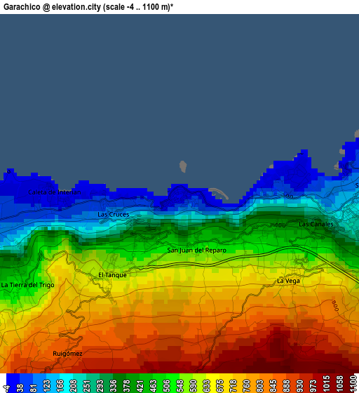
Below is the Elevation map of Garachico, which displays elevation range with different colors. Scale of the first map is from -4 to 1100 m (-13 to 3609 ft) with average elevation of 569 meters (=1867 ft) [note 1]
These maps also provides idea of topography and contour of this city, they are displayed at different zoom levels. More info about maps, scale and edge coordinates you can find below images.
| \ | Map #1 | Map #2 | Topo.Map |
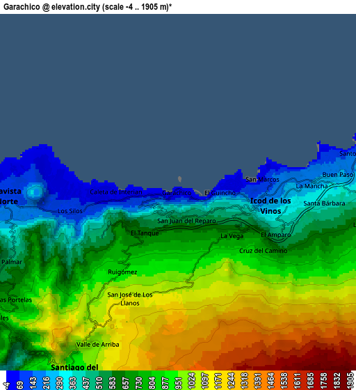
| Scale [m] | -4..1100 m | -4..1905 m | × |
| Scale [ft] | -13..3609 ft | -13..6250 ft | × |
| Average | 569 m = 1867 ft | 806.9 m = 2647 ft | × |
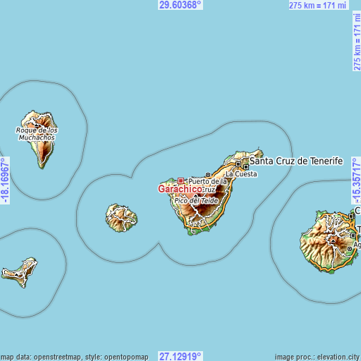
| Width | 8.6 km = 5.3 mi | 17.2 km = 10.7 mi | 275.1 km = 170.9 mi |
| Height | 8.6 km = 5.3 mi | 17.2 km = 10.7 mi | 275.1 km = 170.9 mi |
| ↑Max Latitude | 28.412309° | 28.450954° | 29.60368° |
| Latitude at center | 28.37365° | 28.37365° | 28.37365° |
| ↓Min Latitude | 28.334977° | 28.29629° | 27.12919° |
| ← Min Longitude | -16.807365° | -16.851311° | -18.16967° |
| Longitude center | -16.76342° | -16.76342° | -16.76342° |
| →Max Longitude | -16.719475° | -16.675529° | -15.35717° |
Nearby cities:
Cities around Garachico sort by population:
• Los Realejos elevation 297 m
17.7 km,  85°
85°
• Realejo Alto 390 m
17.4 km, 88°
• Puerto de la Cruz 43 m
21.5 km,  77°
77°
• Icod de los Vinos 219 m
5 km, 91°
• Guía de Isora 594 m
18.1 km,  184°
184°
• Santiago del Teide 922 m
10.3 km,  210°
210°
• Los Silos 98 m
5.2 km,  260°
260°
• La Guancha 497 m
10.9 km, 90°
• Buenavista del Norte 38 m
9.5 km,  270°
270°
• San Juan de la Rambla 99 m
11.3 km, 79°
• Tanque 141 m
6.9 km, 263°
• Los Gigantes 20 m
16.4 km, 207°
Multilingual:
 En español:
Garachico elevación 19 m.
 En France:
Garachico élévation 19 m.
 Auf Deutsch:
Garachico höhe über dem Meeresspiegel ist 19 m.

Sources and notes:
- [note 1] Map square and city borders are not equal. Map elevation data is calculated only from area inside that square.
- [src 1] Elevation data from geonames database provided with same terms of usage.
- [src 2] The elevation map of Garachico is generated using elevation data from NASA's 3 arcsec (90m) resolution SRTM data.
- [src 3] Base (background) map © OpenStreetMap contributors tiles are generated by Geofabrik and OpenTopoMap.
Copyright & License:
This Garachico Elevation Map is licensed under CC BY-SA. You may reuse any part from this page, if you give a proper credit by linking to this URL:
 More info on terms of use page.