Guareña elevation
Guareña (Extremadura, Provincia de Badajoz), Spain elevation is 281 meters and Guareña elevation in feet is 922 ft above sea level [src 1]. Guareña is a populated place (feature code) with elevation that is 322 meters (1056 ft) smaller than average city elevation in Spain.
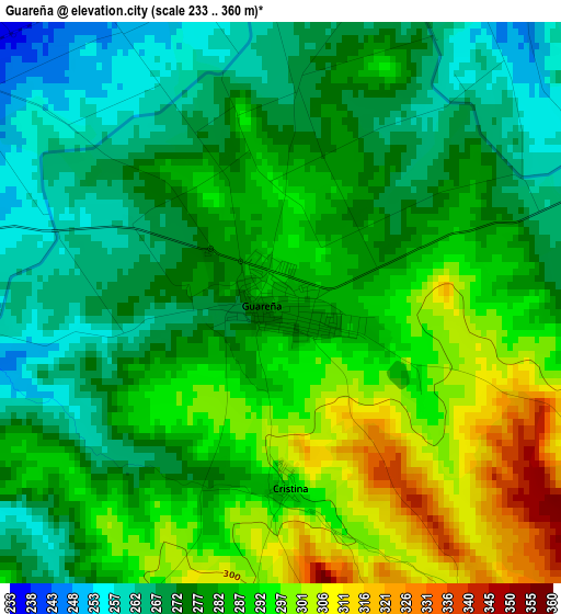
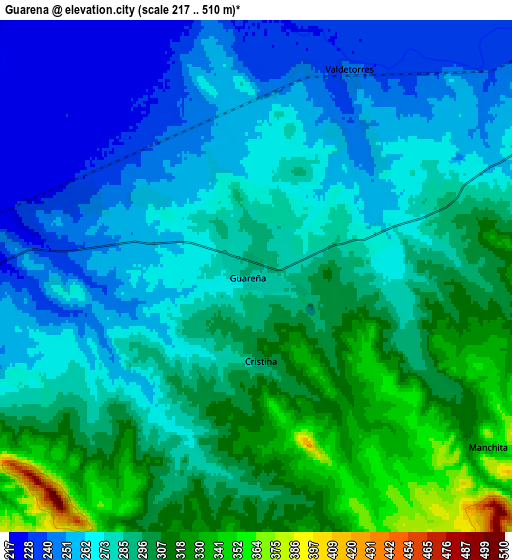
Below is the Elevation map of Guareña, which displays elevation range with different colors. Scale of the first map is from 233 to 360 m (764 to 1181 ft) with average elevation of 282.2 meters (=926 ft) [note 1]
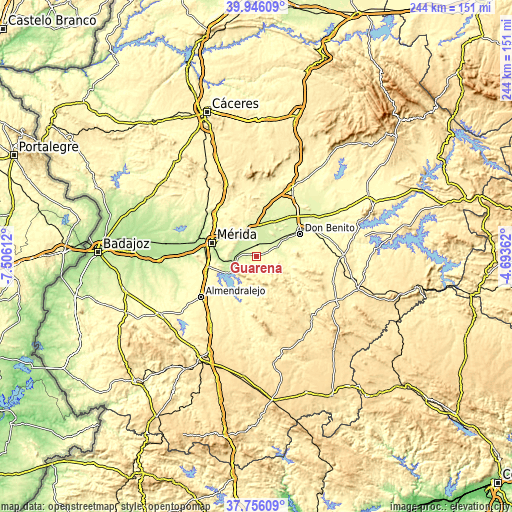
These maps also provides idea of topography and contour of this city, they are displayed at different zoom levels. More info about maps, scale and edge coordinates you can find below images.
| \ | Map #1 | Map #2 | Topo.Map |
| Scale [m] | 233..360 m | 217..510 m | × |
| Scale [ft] | 764..1181 ft | 712..1673 ft | × |
| Average | 282.2 m = 926 ft | 282.3 m = 926 ft | × |
| Width | 7.61 km = 4.7 mi | 15.22 km = 9.5 mi | 243.5 km = 151.3 mi |
| Height | 7.61 km = 4.7 mi | 15.22 km = 9.5 mi | 243.5 km = 151.3 mi |
| ↑Max Latitude | 38.893731° | 38.927926° | 39.94609° |
| Latitude at center | 38.85952° | 38.85952° | 38.85952° |
| ↓Min Latitude | 38.825292° | 38.791048° | 37.75609° |
| ← Min Longitude | -6.143815° | -6.187761° | -7.50612° |
| Longitude center | -6.09987° | -6.09987° | -6.09987° |
| →Max Longitude | -6.055925° | -6.011979° | -4.69362° |
Nearby cities:
Cities around Guareña sort by population:
• Zarza de Alange elevation 286 m
11.2 km,  245°
245°
• Medellín 251 m
16.8 km,  46°
46°
• Alange 316 m
15.1 km,  236°
236°
• Oliva de Mérida 322 m
8 km,  195°
195°
• Villagonzalo 237 m
8.4 km,  272°
272°
• Valdetorres 243 m
6.8 km,  24°
24°
• Valverde de Mérida 268 m
11.9 km,  298°
298°
• San Pedro de Mérida 290 m
12.5 km,  323°
323°
• Manchita 346 m
8.5 km,  126°
126°
• Don Álvaro 264 m
15.2 km, 265°
• Cristina 296 m
2.5 km,  177°
177°
• Mengabril 253 m
16.7 km,  59°
59°
Multilingual:
 En español:
Guareña elevación 281 m.
 En France:
Guareña élévation 281 m.


Sources and notes:
- [note 1] Map square and city borders are not equal. Map elevation data is calculated only from area inside that square.
- [src 1] Elevation data from geonames database provided with same terms of usage.
- [src 2] The elevation map of Guareña is generated using elevation data from NASA's 3 arcsec (90m) resolution SRTM data.
- [src 3] Base (background) map © OpenStreetMap contributors tiles are generated by Geofabrik and OpenTopoMap.
Copyright & License:
This Guareña Elevation Map is licensed under CC BY-SA. You may reuse any part from this page, if you give a proper credit by linking to this URL:
 More info on terms of use page.