Jerez de los Caballeros elevation
Jerez de los Caballeros (Extremadura, Provincia de Badajoz), Spain elevation is 486 meters and Jerez de los Caballeros elevation in feet is 1594 ft above sea level [src 1]. Jerez de los Caballeros is a seat of a third-order administrative division (feature code) with elevation that is 117 meters (384 ft) smaller than average city elevation in Spain.
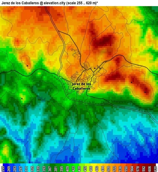
Below is the Elevation map of Jerez de los Caballeros, which displays elevation range with different colors. Scale of the first map is from 255 to 620 m (837 to 2034 ft) with average elevation of 426.3 meters (=1399 ft) [note 1]
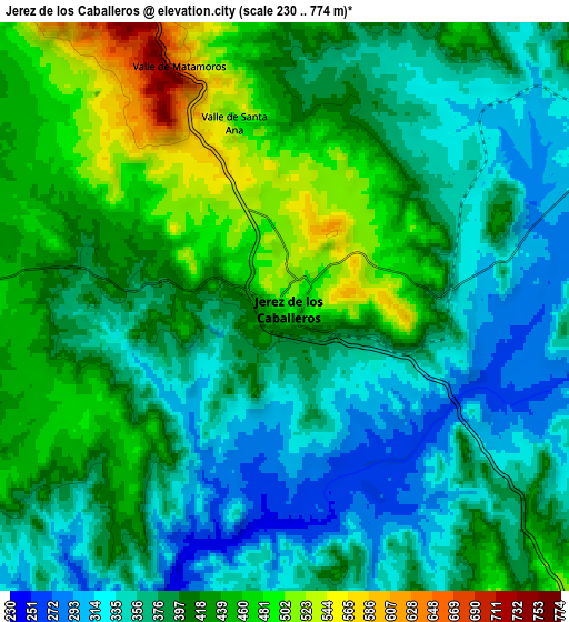
These maps also provides idea of topography and contour of this city, they are displayed at different zoom levels. More info about maps, scale and edge coordinates you can find below images.
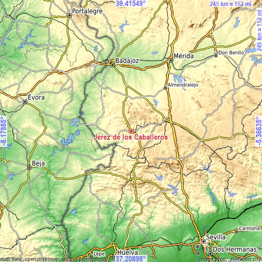
| \ | Map #1 | Map #2 | Topo.Map |
| Scale [m] | 255..620 m | 230..774 m | × |
| Scale [ft] | 837..2034 ft | 755..2539 ft | × |
| Average | 426.3 m = 1399 ft | 398.7 m = 1308 ft | × |
| Width | 7.67 km = 4.8 mi | 15.33 km = 9.5 mi | 245.3 km = 152.4 mi |
| Height | 7.67 km = 4.8 mi | 15.33 km = 9.5 mi | 245.3 km = 152.4 mi |
| ↑Max Latitude | 38.355099° | 38.389552° | 39.41549° |
| Latitude at center | 38.32063° | 38.32063° | 38.32063° |
| ↓Min Latitude | 38.286144° | 38.251642° | 37.20898° |
| ← Min Longitude | -6.816545° | -6.860491° | -8.17885° |
| Longitude center | -6.7726° | -6.7726° | -6.7726° |
| →Max Longitude | -6.728655° | -6.684709° | -5.36635° |
Nearby cities:
Cities around Jerez de los Caballeros sort by population:
• Oliva de la Frontera elevation 376 m
13.7 km,  248°
248°
• Fregenal de la Sierra 572 m
19.8 km,  148°
148°
• Burguillos del Cerro 405 m
17.2 km,  67°
67°
• Zahinos 330 m
16 km,  274°
274°
• Higuera la Real 623 m
21.3 km,  159°
159°
• Salvaleón 531 m
21.1 km,  356°
356°
• Higuera de Vargas 358 m
22.6 km,  308°
308°
• Salvatierra de los Barros 621 m
20.4 km,  22°
22°
• Valle de Santa Ana 503 m
5.3 km,  344°
344°
• Valle de Matamoros 602 m
7 km, 337°
• Valverde de Burguillos 415 m
20.6 km,  87°
87°
• Encinasola 428 m
22.3 km,  201°
201°
Multilingual:
 En español:
Jerez de los Caballeros elevación 486 m.
 En France:
Jerez de los Caballeros élévation 486 m.
 Auf Deutsch:
Jerez de los Caballeros höhe über dem Meeresspiegel ist 486 m.
 На русском:
Херес-де-лос-Кабальерос высота над уровнем моря 486 м
Sources and notes:
- [note 1] Map square and city borders are not equal. Map elevation data is calculated only from area inside that square.
- [src 1] Elevation data from geonames database provided with same terms of usage.
- [src 2] The elevation map of Jerez de los Caballeros is generated using elevation data from NASA's 3 arcsec (90m) resolution SRTM data.
- [src 3] Base (background) map © OpenStreetMap contributors tiles are generated by Geofabrik and OpenTopoMap.
Copyright & License:
This Jerez de los Caballeros Elevation Map is licensed under CC BY-SA. You may reuse any part from this page, if you give a proper credit by linking to this URL:
 More info on terms of use page.