Jérica elevation
Jérica (Valencia, Província de Castelló), Spain elevation is 528 meters and Jérica elevation in feet is 1732 ft above sea level [src 1]. Jérica is a seat of a third-order administrative division (feature code) with elevation that is 75 meters (246 ft) smaller than average city elevation in Spain.
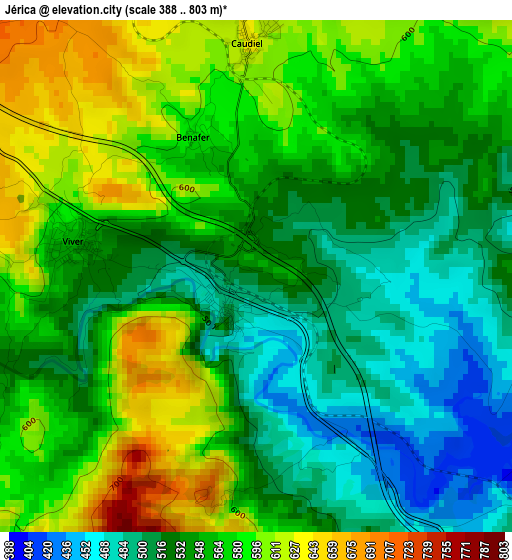
Below is the Elevation map of Jérica, which displays elevation range with different colors. Scale of the first map is from 388 to 803 m (1273 to 2635 ft) with average elevation of 552 meters (=1811 ft) [note 1]
These maps also provides idea of topography and contour of this city, they are displayed at different zoom levels. More info about maps, scale and edge coordinates you can find below images.
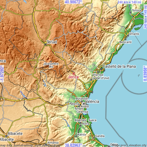
| \ | Map #1 | Topo.Map |
| Scale [m] | 388..803 m | × |
| Scale [ft] | 1273..2635 ft | × |
| Average | 552 m = 1811 ft | × |
| Width | 7.5 km = 4.7 mi | 239.8 km = 149 mi |
| Height | 7.5 km = 4.7 mi | 239.8 km = 149 mi |
| ↑Max Latitude | 39.950367° | 40.98672° |
| Latitude at center | 39.91667° | 39.91667° |
| ↓Min Latitude | 39.882957° | 38.82963° |
| ← Min Longitude | -0.610615° | -1.97292° |
| Longitude center | -0.56667° | -0.56667° |
| →Max Longitude | -0.522725° | 0.83958° |
Nearby cities:
Cities around Jérica sort by population:
• Segorbe elevation 340 m
10.3 km,  136°
136°
• Altura 396 m
8.6 km,  150°
150°
• Viver 542 m
2.8 km,  270°
270°
• Castellnovo 386 m
11.4 km,  119°
119°
• Navajas 401 m
6.8 km, 123°
• Torás 727 m
9.9 km, 270°
• Algimia de Almonacid 529 m
11.4 km,  90°
90°
• Vall de Almonacid 467 m
10.1 km,  100°
100°
• Gaibiel 595 m
7.3 km,  75°
75°
• Matet 617 m
8.7 km, 77°
• Higueras 688 m
9.3 km,  37°
37°
• Pavías 832 m
9 km,  51°
51°
Multilingual:
 En español:
Jerica elevación 528 m.
 En France:
Jérica élévation 528 m.


Sources and notes:
- [note 1] Map square and city borders are not equal. Map elevation data is calculated only from area inside that square.
- [src 1] Elevation data from geonames database provided with same terms of usage.
- [src 2] The elevation map of Jérica is generated using elevation data from NASA's 3 arcsec (90m) resolution SRTM data.
- [src 3] Base (background) map © OpenStreetMap contributors tiles are generated by Geofabrik and OpenTopoMap.
Copyright & License:
This Jérica Elevation Map is licensed under CC BY-SA. You may reuse any part from this page, if you give a proper credit by linking to this URL:
 More info on terms of use page.