La Matanza de Acentejo elevation
La Matanza de Acentejo (Canary Islands, Provincia de Santa Cruz de Tenerife), Spain elevation is 515 meters and La Matanza de Acentejo elevation in feet is 1690 ft above sea level [src 1]. La Matanza de Acentejo is a seat of a third-order administrative division (feature code) with elevation that is 88 meters (289 ft) smaller than average city elevation in Spain.
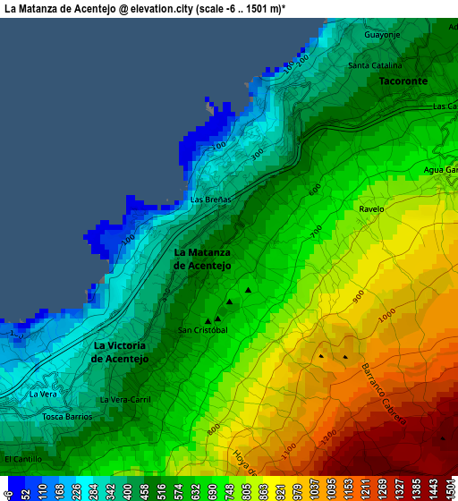
Below is the Elevation map of La Matanza de Acentejo, which displays elevation range with different colors. Scale of the first map is from -6 to 1501 m (-20 to 4925 ft) with average elevation of 669 meters (=2195 ft) [note 1]
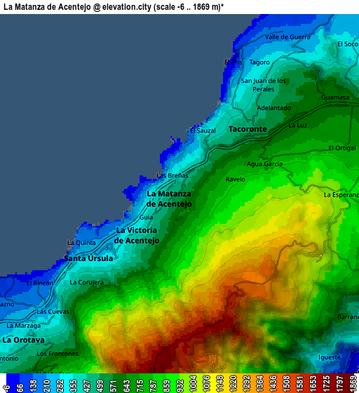
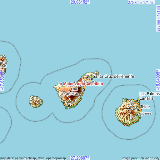
These maps also provides idea of topography and contour of this city, they are displayed at different zoom levels. More info about maps, scale and edge coordinates you can find below images.
| \ | Map #1 | Map #2 | Topo.Map |
| Scale [m] | -6..1501 m | -6..1869 m | × |
| Scale [ft] | -20..4925 ft | -20..6132 ft | × |
| Average | 669 m = 2195 ft | 753.2 m = 2471 ft | × |
| Width | 8.59 km = 5.3 mi | 17.18 km = 10.7 mi | 274.9 km = 170.8 mi |
| Height | 8.59 km = 5.3 mi | 17.18 km = 10.7 mi | 274.9 km = 170.8 mi |
| ↑Max Latitude | 28.49105° | 28.529666° | 29.68152° |
| Latitude at center | 28.45242° | 28.45242° | 28.45242° |
| ↓Min Latitude | 28.413776° | 28.375117° | 27.20887° |
| ← Min Longitude | -16.491145° | -16.535091° | -17.85345° |
| Longitude center | -16.4472° | -16.4472° | -16.4472° |
| →Max Longitude | -16.403255° | -16.359309° | -15.04095° |
Nearby cities:
Cities around La Matanza de Acentejo sort by population:
• La Laguna elevation 558 m
12.9 km,  73°
73°
• La Orotava 355 m
10.1 km,  227°
227°
• Los Realejos 297 m
15.2 km,  240°
240°
• Realejo Alto 390 m
16 km, 238°
• Puerto de la Cruz 43 m
10.8 km,  246°
246°
• Candelaria 36 m
13.1 km,  146°
146°
• Tacoronte 569 m
4.5 km,  53°
53°
• Santa Úrsula 283 m
5 km, 234°
• Tegueste 511 m
14.6 km,  60°
60°
• La Victoria de Acentejo 481 m
2.7 km,  213°
213°
• Sauzal 681 m
3.4 km, 62°
• Arafo 500 m
12.8 km,  169°
169°
Multilingual:
 En español:
La Matanza de Acentejo elevación 515 m.
 En France:
La Matanza de Acentejo élévation 515 m.
 Auf Deutsch:
La Matanza de Acentejo höhe über dem Meeresspiegel ist 515 m.
 На русском:
Ла-Матанса-де-Асентехо высота над уровнем моря 515 м
Sources and notes:
- [note 1] Map square and city borders are not equal. Map elevation data is calculated only from area inside that square.
- [src 1] Elevation data from geonames database provided with same terms of usage.
- [src 2] The elevation map of La Matanza de Acentejo is generated using elevation data from NASA's 3 arcsec (90m) resolution SRTM data.
- [src 3] Base (background) map © OpenStreetMap contributors tiles are generated by Geofabrik and OpenTopoMap.
Copyright & License:
This La Matanza de Acentejo Elevation Map is licensed under CC BY-SA. You may reuse any part from this page, if you give a proper credit by linking to this URL:
 More info on terms of use page.