La Roda elevation
La Roda (Castille-La Mancha, Provincia de Albacete), Spain elevation is 713 meters and La Roda elevation in feet is 2339 ft above sea level [src 1]. La Roda is a populated place (feature code) with elevation that is 110 meters (361 ft) bigger than average city elevation in Spain.
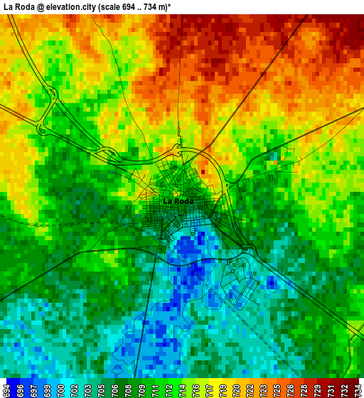
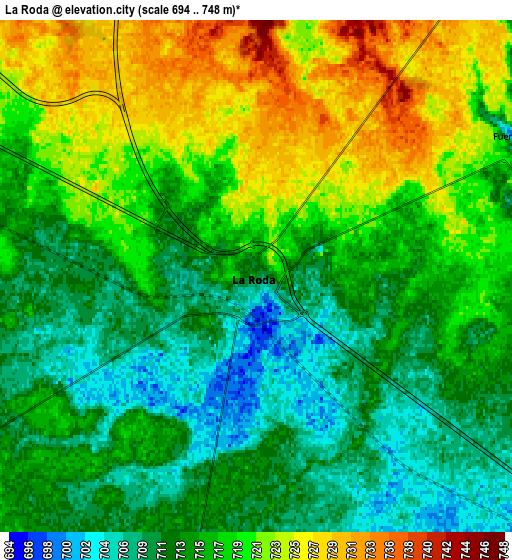
Below is the Elevation map of La Roda, which displays elevation range with different colors. Scale of the first map is from 694 to 734 m (2277 to 2408 ft) with average elevation of 712.4 meters (=2337 ft) [note 1]
These maps also provides idea of topography and contour of this city, they are displayed at different zoom levels. More info about maps, scale and edge coordinates you can find below images.
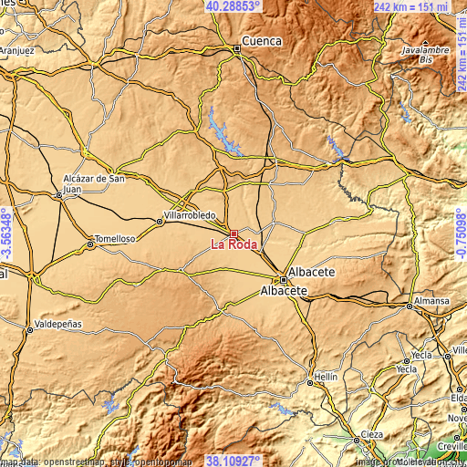
| \ | Map #1 | Map #2 | Topo.Map |
| Scale [m] | 694..734 m | 694..748 m | × |
| Scale [ft] | 2277..2408 ft | 2277..2454 ft | × |
| Average | 712.4 m = 2337 ft | 716.3 m = 2350 ft | × |
| Width | 7.57 km = 4.7 mi | 15.14 km = 9.4 mi | 242.3 km = 150.6 mi |
| Height | 7.57 km = 4.7 mi | 15.14 km = 9.4 mi | 242.3 km = 150.6 mi |
| ↑Max Latitude | 39.241393° | 39.27542° | 40.28853° |
| Latitude at center | 39.20735° | 39.20735° | 39.20735° |
| ↓Min Latitude | 39.17329° | 39.139214° | 38.10927° |
| ← Min Longitude | -2.201175° | -2.245121° | -3.56348° |
| Longitude center | -2.15723° | -2.15723° | -2.15723° |
| →Max Longitude | -2.113285° | -2.069339° | -0.75098° |
Nearby cities:
Cities around La Roda sort by population:
• Tarazona de la Mancha elevation 722 m
21.3 km,  77°
77°
• Casasimarro 768 m
20.7 km,  31°
31°
• La Gineta 690 m
17.3 km,  126°
126°
• Barrax 735 m
18.3 km,  192°
192°
• Minaya 730 m
15.8 km,  296°
296°
• Villagordo del Júcar 672 m
12.9 km,  37°
37°
• Casas de Benítez 752 m
17.8 km,  6°
6°
• Casas de Haro 724 m
17.2 km,  324°
324°
• Pozoamargo 751 m
17.9 km,  349°
349°
• Fuensanta 717 m
8.3 km,  69°
69°
• Montalvos 707 m
12.9 km,  110°
110°
• Casas de Guijarro 740 m
15.9 km,  357°
357°
Multilingual:
 En español:
La Roda elevación 713 m.
 En France:
La Roda élévation 713 m.


Sources and notes:
- [note 1] Map square and city borders are not equal. Map elevation data is calculated only from area inside that square.
- [src 1] Elevation data from geonames database provided with same terms of usage.
- [src 2] The elevation map of La Roda is generated using elevation data from NASA's 3 arcsec (90m) resolution SRTM data.
- [src 3] Base (background) map © OpenStreetMap contributors tiles are generated by Geofabrik and OpenTopoMap.
Copyright & License:
This La Roda Elevation Map is licensed under CC BY-SA. You may reuse any part from this page, if you give a proper credit by linking to this URL:
 More info on terms of use page.