La Unión elevation
La Unión (Murcia), Spain elevation is 104 meters and La Unión elevation in feet is 341 ft above sea level [src 1]. La Unión is a populated place (feature code) with elevation that is 499 meters (1637 ft) smaller than average city elevation in Spain.
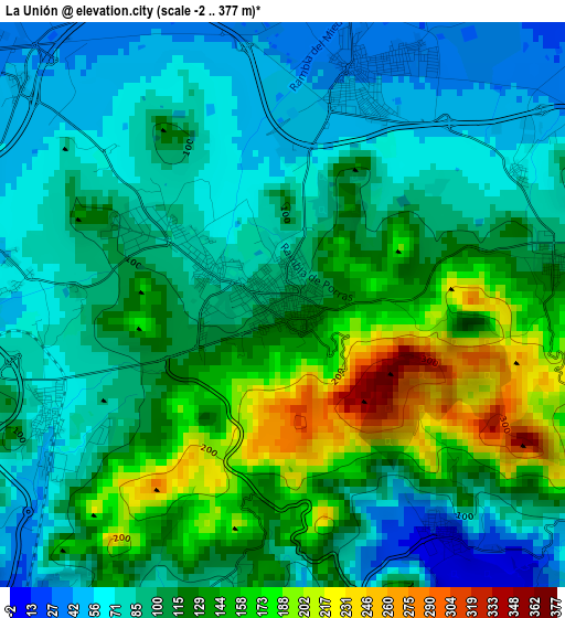
Below is the Elevation map of La Unión, which displays elevation range with different colors. Scale of the first map is from -2 to 377 m (-7 to 1237 ft) with average elevation of 110.1 meters (=361 ft) [note 1]
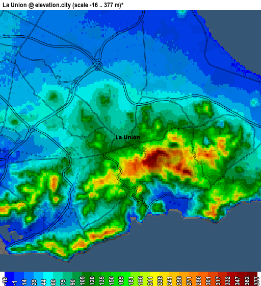
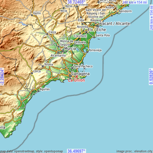
These maps also provides idea of topography and contour of this city, they are displayed at different zoom levels. More info about maps, scale and edge coordinates you can find below images.
| \ | Map #1 | Map #2 | Topo.Map |
| Scale [m] | -2..377 m | -16..377 m | × |
| Scale [ft] | -7..1237 ft | -52..1237 ft | × |
| Average | 110.1 m = 361 ft | 74.3 m = 244 ft | × |
| Width | 7.74 km = 4.8 mi | 15.48 km = 9.6 mi | 247.7 km = 153.9 mi |
| Height | 7.74 km = 4.8 mi | 15.48 km = 9.6 mi | 247.7 km = 153.9 mi |
| ↑Max Latitude | 37.65395° | 37.688734° | 38.72465° |
| Latitude at center | 37.61915° | 37.61915° | 37.61915° |
| ↓Min Latitude | 37.584333° | 37.549501° | 36.49697° |
| ← Min Longitude | -0.921935° | -0.965881° | -2.28424° |
| Longitude center | -0.87799° | -0.87799° | -0.87799° |
| →Max Longitude | -0.834045° | -0.790099° | 0.52826° |
Nearby cities:
Cities around La Unión sort by population:
• Cartagena elevation 5 m
9.7 km,  260°
260°
• Torre-Pacheco 43 m
15.3 km,  334°
334°
• San Javier 27 m
21.1 km,  9°
9°
• Atamaría 98 m
6.6 km,  108°
108°
• San Pedro del Pinatar 15 m
25.3 km,  17°
17°
• Los Alcázares 4 m
14.1 km, 9°
• La Manga del Mar Menor 2 m
14.4 km,  80°
80°
• Santiago de la Ribera 7 m
20.8 km, 17°
• El Plan 49 m
12.7 km,  285°
285°
• Los Gabatos 23 m
10.9 km,  278°
278°
• Barrio de la Concepción 54 m
11 km, 258°
• Lo Pagán 4 m
23.4 km, 19°
Multilingual:
 En español:
La Unión elevación 104 m.
 En France:
La Unión élévation 104 m.
 Auf Deutsch:
La Unión höhe über dem Meeresspiegel ist 104 m.

Sources and notes:
- [note 1] Map square and city borders are not equal. Map elevation data is calculated only from area inside that square.
- [src 1] Elevation data from geonames database provided with same terms of usage.
- [src 2] The elevation map of La Unión is generated using elevation data from NASA's 3 arcsec (90m) resolution SRTM data.
- [src 3] Base (background) map © OpenStreetMap contributors tiles are generated by Geofabrik and OpenTopoMap.
Copyright & License:
This La Unión Elevation Map is licensed under CC BY-SA. You may reuse any part from this page, if you give a proper credit by linking to this URL:
 More info on terms of use page.