Llera elevation
Llera (Extremadura, Provincia de Badajoz), Spain elevation is 440 meters and Llera elevation in feet is 1444 ft above sea level [src 1]. Llera is a seat of a third-order administrative division (feature code) with elevation that is 163 meters (535 ft) smaller than average city elevation in Spain.
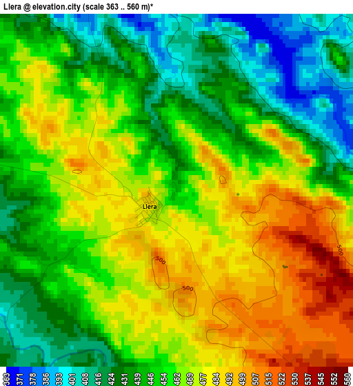
Below is the Elevation map of Llera, which displays elevation range with different colors. Scale of the first map is from 363 to 560 m (1191 to 1837 ft) with average elevation of 456.8 meters (=1499 ft) [note 1]
These maps also provides idea of topography and contour of this city, they are displayed at different zoom levels. More info about maps, scale and edge coordinates you can find below images.
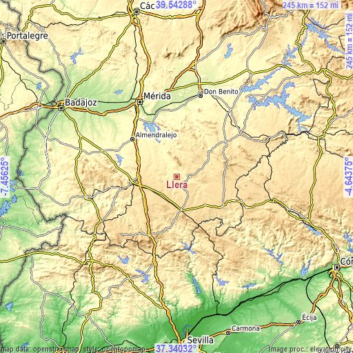
| \ | Map #1 | Topo.Map |
| Scale [m] | 363..560 m | × |
| Scale [ft] | 1191..1837 ft | × |
| Average | 456.8 m = 1499 ft | × |
| Width | 7.65 km = 4.8 mi | 244.9 km = 152.2 mi |
| Height | 7.65 km = 4.8 mi | 244.9 km = 152.2 mi |
| ↑Max Latitude | 38.484408° | 39.54288° |
| Latitude at center | 38.45° | 38.45° |
| ↓Min Latitude | 38.415576° | 37.34032° |
| ← Min Longitude | -6.093945° | -7.45625° |
| Longitude center | -6.05° | -6.05° |
| →Max Longitude | -6.006055° | -4.64375° |
Nearby cities:
Cities around Llera sort by population:
• El Casar elevation 499 m
14.1 km,  50°
50°
• Llerena 650 m
24.3 km,  173°
173°
• Hornachos 482 m
11.7 km,  352°
352°
• Ribera del Fresno 404 m
19.9 km,  304°
304°
• Bienvenida 611 m
21.2 km,  218°
218°
• Usagre 567 m
15.1 km, 222°
• Campillo de Llerena 490 m
19.9 km,  73°
73°
• Maguilla 546 m
21 km,  116°
116°
• Villagarcía de la Torre 582 m
16.9 km,  189°
189°
• Valencia de las Torres 512 m
6.4 km,  141°
141°
• Hinojosa del Valle 440 m
12.2 km,  287°
287°
• Puebla del Prior 388 m
18.4 km,  316°
316°
Multilingual:
 En español:
Llera elevación 440 m.
 En France:
Llera élévation 440 m.


Sources and notes:
- [note 1] Map square and city borders are not equal. Map elevation data is calculated only from area inside that square.
- [src 1] Elevation data from geonames database provided with same terms of usage.
- [src 2] The elevation map of Llera is generated using elevation data from NASA's 3 arcsec (90m) resolution SRTM data.
- [src 3] Base (background) map © OpenStreetMap contributors tiles are generated by Geofabrik and OpenTopoMap.
Copyright & License:
This Llera Elevation Map is licensed under CC BY-SA. You may reuse any part from this page, if you give a proper credit by linking to this URL:
 More info on terms of use page.