Lloseta elevation
Lloseta (Balearic Islands, Illes Balears), Spain elevation is 157 meters and Lloseta elevation in feet is 515 ft above sea level [src 1]. Lloseta is a seat of a third-order administrative division (feature code) with elevation that is 446 meters (1463 ft) smaller than average city elevation in Spain.
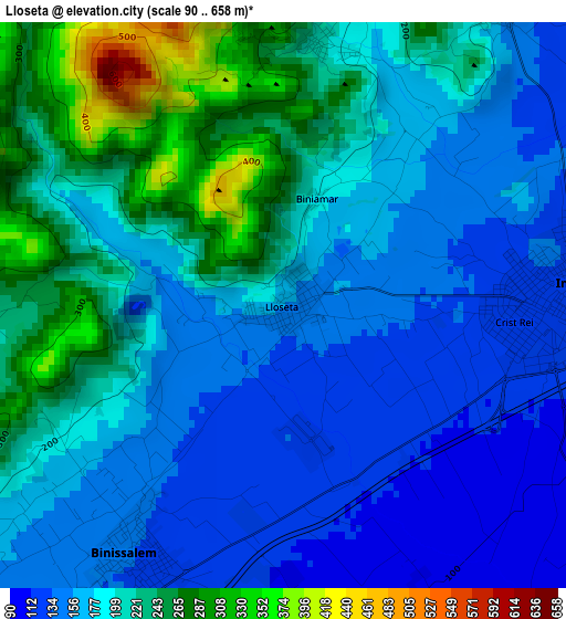
Below is the Elevation map of Lloseta, which displays elevation range with different colors. Scale of the first map is from 90 to 658 m (295 to 2159 ft) with average elevation of 189.9 meters (=623 ft) [note 1]
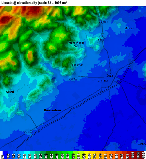
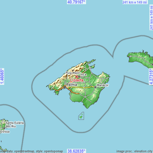
These maps also provides idea of topography and contour of this city, they are displayed at different zoom levels. More info about maps, scale and edge coordinates you can find below images.
| \ | Map #1 | Map #2 | Topo.Map |
| Scale [m] | 90..658 m | 62..1096 m | × |
| Scale [ft] | 295..2159 ft | 203..3596 ft | × |
| Average | 189.9 m = 623 ft | 230.9 m = 758 ft | × |
| Width | 7.52 km = 4.7 mi | 15.03 km = 9.3 mi | 240.5 km = 149.4 mi |
| Height | 7.52 km = 4.7 mi | 15.03 km = 9.3 mi | 240.5 km = 149.4 mi |
| ↑Max Latitude | 39.752284° | 39.786062° | 40.79167° |
| Latitude at center | 39.71849° | 39.71849° | 39.71849° |
| ↓Min Latitude | 39.684679° | 39.650852° | 38.62835° |
| ← Min Longitude | 2.822955° | 2.779009° | 1.46065° |
| Longitude center | 2.8669° | 2.8669° | 2.8669° |
| →Max Longitude | 2.910845° | 2.954791° | 4.27315° |
Nearby cities:
Cities around Lloseta sort by population:
• Inca elevation 127 m
3.8 km,  85°
85°
• Binissalem 133 m
4 km,  209°
209°
• Alaró 217 m
6.6 km,  256°
256°
• Selva 198 m
5 km,  35°
35°
• Consell 152 m
7.2 km,  219°
219°
• Sencelles 115 m
8.5 km,  161°
161°
• Campanet 132 m
10.5 km,  53°
53°
• Santa Eugènia 138 m
10.8 km,  192°
192°
• Búger 91 m
10.9 km,  66°
66°
• Costitx 136 m
9.9 km,  134°
134°
• Mancor de la Vall 208 m
3.5 km,  8°
8°
• Santa Maria del Camí 131 m
11 km,  226°
226°
Multilingual:
 En español:
Lloseta elevación 157 m.
 En France:
Lloseta élévation 157 m.


Sources and notes:
- [note 1] Map square and city borders are not equal. Map elevation data is calculated only from area inside that square.
- [src 1] Elevation data from geonames database provided with same terms of usage.
- [src 2] The elevation map of Lloseta is generated using elevation data from NASA's 3 arcsec (90m) resolution SRTM data.
- [src 3] Base (background) map © OpenStreetMap contributors tiles are generated by Geofabrik and OpenTopoMap.
Copyright & License:
This Lloseta Elevation Map is licensed under CC BY-SA. You may reuse any part from this page, if you give a proper credit by linking to this URL:
 More info on terms of use page.