Llucmajor elevation
Llucmajor (Balearic Islands, Illes Balears), Spain elevation is 150 meters and Llucmajor elevation in feet is 492 ft above sea level [src 1]. Llucmajor is a seat of a third-order administrative division (feature code) with elevation that is 453 meters (1486 ft) smaller than average city elevation in Spain.
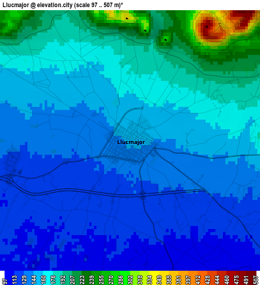
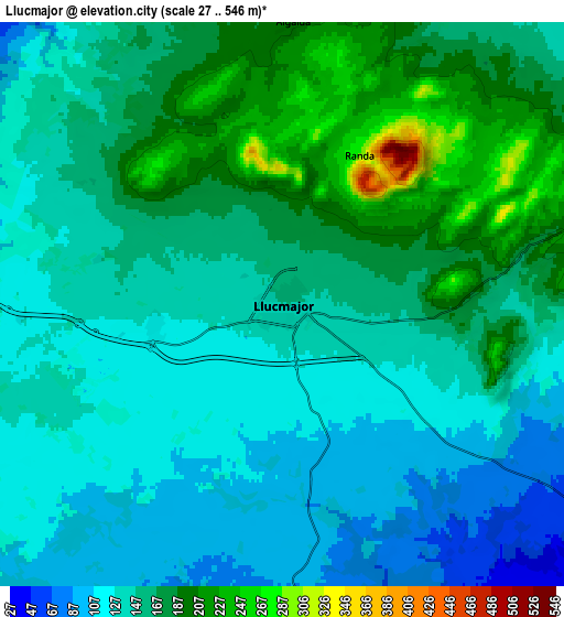
Below is the Elevation map of Llucmajor, which displays elevation range with different colors. Scale of the first map is from 97 to 507 m (318 to 1663 ft) with average elevation of 157.1 meters (=515 ft) [note 1]
These maps also provides idea of topography and contour of this city, they are displayed at different zoom levels. More info about maps, scale and edge coordinates you can find below images.
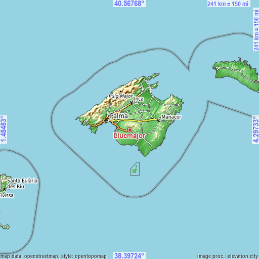
| \ | Map #1 | Map #2 | Topo.Map |
| Scale [m] | 97..507 m | 27..546 m | × |
| Scale [ft] | 318..1663 ft | 89..1791 ft | × |
| Average | 157.1 m = 515 ft | 149.9 m = 492 ft | × |
| Width | 7.54 km = 4.7 mi | 15.08 km = 9.4 mi | 241.3 km = 149.9 mi |
| Height | 7.54 km = 4.7 mi | 15.08 km = 9.4 mi | 241.3 km = 149.9 mi |
| ↑Max Latitude | 39.524835° | 39.558724° | 40.56768° |
| Latitude at center | 39.49093° | 39.49093° | 39.49093° |
| ↓Min Latitude | 39.457008° | 39.42307° | 38.39724° |
| ← Min Longitude | 2.847135° | 2.803189° | 1.48483° |
| Longitude center | 2.89108° | 2.89108° | 2.89108° |
| →Max Longitude | 2.935025° | 2.978971° | 4.29733° |
Nearby cities:
Cities around Llucmajor sort by population:
• Coll d'en Rabassa elevation 12 m
18.1 km,  291°
291°
• s'Arenal 5 m
12.1 km,  274°
274°
• Campos 25 m
12.9 km,  121°
121°
• Can Pastilla 8 m
15.7 km, 288°
• Porreres 128 m
11.5 km,  76°
76°
• Algaida 197 m
7.6 km,  2°
2°
• Sencelles 115 m
17.2 km, 1°
• Montuïri 167 m
11.5 km,  42°
42°
• Vilafranca de Bonany 101 m
19 km,  62°
62°
• Santa Eugènia 138 m
15.4 km,  343°
343°
• Lloret de Vistalegre 171 m
15.9 km,  26°
26°
• Sant Joan 138 m
17.3 km,  47°
47°
Multilingual:
 En español:
Llucmajor elevación 150 m.
 En France:
Llucmajor élévation 150 m.
 Auf Deutsch:
Llucmajor höhe über dem Meeresspiegel ist 150 m.

Sources and notes:
- [note 1] Map square and city borders are not equal. Map elevation data is calculated only from area inside that square.
- [src 1] Elevation data from geonames database provided with same terms of usage.
- [src 2] The elevation map of Llucmajor is generated using elevation data from NASA's 3 arcsec (90m) resolution SRTM data.
- [src 3] Base (background) map © OpenStreetMap contributors tiles are generated by Geofabrik and OpenTopoMap.
Copyright & License:
This Llucmajor Elevation Map is licensed under CC BY-SA. You may reuse any part from this page, if you give a proper credit by linking to this URL:
 More info on terms of use page.