Mislata elevation
Mislata (Valencia, Província de València), Spain elevation is 35 meters and Mislata elevation in feet is 115 ft above sea level [src 1]. Mislata is a seat of a third-order administrative division (feature code) with elevation that is 568 meters (1864 ft) smaller than average city elevation in Spain.
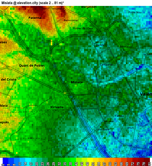
Below is the Elevation map of Mislata, which displays elevation range with different colors. Scale of the first map is from 2 to 81 m (7 to 266 ft) with average elevation of 31 meters (=102 ft) [note 1]
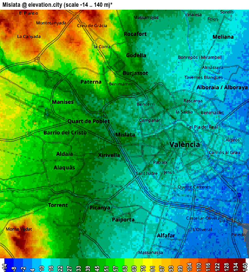
These maps also provides idea of topography and contour of this city, they are displayed at different zoom levels. More info about maps, scale and edge coordinates you can find below images.
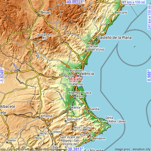
| \ | Map #1 | Map #2 | Topo.Map |
| Scale [m] | 2..81 m | -14..140 m | × |
| Scale [ft] | 7..266 ft | -46..459 ft | × |
| Average | 31 m = 102 ft | 36.7 m = 120 ft | × |
| Width | 7.54 km = 4.7 mi | 15.09 km = 9.4 mi | 241.4 km = 150 mi |
| Height | 7.54 km = 4.7 mi | 15.09 km = 9.4 mi | 241.4 km = 150 mi |
| ↑Max Latitude | 39.509143° | 39.54304° | 40.55223° |
| Latitude at center | 39.47523° | 39.47523° | 39.47523° |
| ↓Min Latitude | 39.4413° | 39.407354° | 38.3813° |
| ← Min Longitude | -0.462195° | -0.506141° | -1.8245° |
| Longitude center | -0.41825° | -0.41825° | -0.41825° |
| →Max Longitude | -0.374305° | -0.330359° | 0.988° |
Nearby cities:
Cities around Mislata sort by population:
• Valencia elevation 23 m
3.6 km,  99°
99°
• Paterna 53 m
3.6 km,  327°
327°
• Burjassot 51 m
3.9 km,  6°
6°
• Xirivella 35 m
1.2 km,  212°
212°
• Manises 55 m
4.3 km,  294°
294°
• Alaquàs 48 m
4.3 km,  239°
239°
• Aldaia 49 m
3.7 km,  253°
253°
• Quart de Poblet 43 m
1.9 km, 290°
• Paiporta 32 m
5.2 km,  179°
179°
• Picanya 35 m
4.8 km,  195°
195°
• Tavernes Blanques 9 m
5.2 km,  58°
58°
• Sedaví 8 m
5.5 km,  147°
147°
Multilingual:
 En español:
Mislata elevación 35 m.
 En France:
Mislata élévation 35 m.


Sources and notes:
- [note 1] Map square and city borders are not equal. Map elevation data is calculated only from area inside that square.
- [src 1] Elevation data from geonames database provided with same terms of usage.
- [src 2] The elevation map of Mislata is generated using elevation data from NASA's 3 arcsec (90m) resolution SRTM data.
- [src 3] Base (background) map © OpenStreetMap contributors tiles are generated by Geofabrik and OpenTopoMap.
Copyright & License:
This Mislata Elevation Map is licensed under CC BY-SA. You may reuse any part from this page, if you give a proper credit by linking to this URL:
 More info on terms of use page.