Mocejón elevation
Mocejón (Castille-La Mancha, Province of Toledo), Spain elevation is 483 meters and Mocejón elevation in feet is 1585 ft above sea level [src 1]. Mocejón is a seat of a third-order administrative division (feature code) with elevation that is 120 meters (394 ft) smaller than average city elevation in Spain.
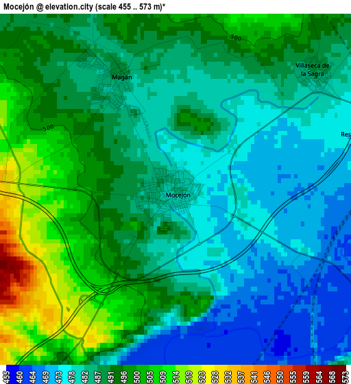
Below is the Elevation map of Mocejón, which displays elevation range with different colors. Scale of the first map is from 455 to 573 m (1493 to 1880 ft) with average elevation of 488.2 meters (=1602 ft) [note 1]
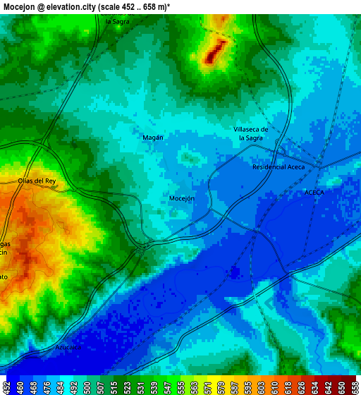
These maps also provides idea of topography and contour of this city, they are displayed at different zoom levels. More info about maps, scale and edge coordinates you can find below images.
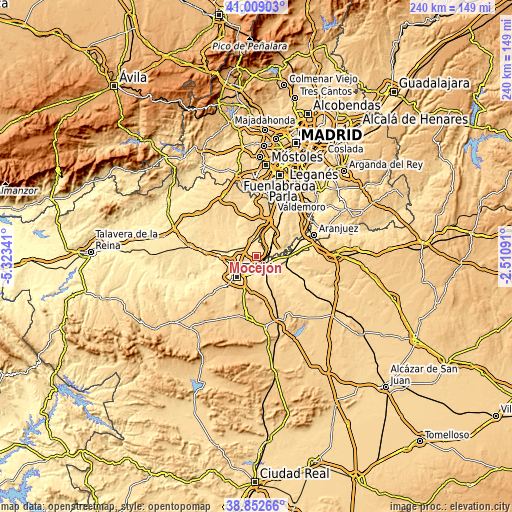
| \ | Map #1 | Map #2 | Topo.Map |
| Scale [m] | 455..573 m | 452..658 m | × |
| Scale [ft] | 1493..1880 ft | 1483..2159 ft | × |
| Average | 488.2 m = 1602 ft | 502.9 m = 1650 ft | × |
| Width | 7.49 km = 4.7 mi | 14.99 km = 9.3 mi | 239.8 km = 149 mi |
| Height | 7.49 km = 4.7 mi | 14.99 km = 9.3 mi | 239.8 km = 149 mi |
| ↑Max Latitude | 39.973026° | 40.006695° | 41.00903° |
| Latitude at center | 39.93934° | 39.93934° | 39.93934° |
| ↓Min Latitude | 39.905638° | 39.871919° | 38.85266° |
| ← Min Longitude | -3.961105° | -4.005051° | -5.32341° |
| Longitude center | -3.91716° | -3.91716° | -3.91716° |
| →Max Longitude | -3.873215° | -3.829269° | -2.51091° |
Nearby cities:
Cities around Mocejón sort by population:
• Toledo elevation 533 m
12.7 km,  224°
224°
• Bargas 594 m
8.8 km,  271°
271°
• Olías del Rey 593 m
6 km,  275°
275°
• Añover de Tajo 598 m
14 km,  66°
66°
• La Alameda de la Sagra 600 m
13.3 km,  52°
52°
• Pantoja 524 m
13.6 km,  31°
31°
• Recas 571 m
14.1 km,  333°
333°
• Yuncler 527 m
11.4 km,  7°
7°
• Cobeja 498 m
10.4 km, 29°
• Cabañas de la Sagra 551 m
7.8 km,  341°
341°
• Magán 488 m
2.7 km, 333°
• Villaseca de la Sagra 488 m
3.8 km, 49°
Multilingual:
 En español:
Mocejón elevación 483 m.
 En France:
Mocejón élévation 483 m.


Sources and notes:
- [note 1] Map square and city borders are not equal. Map elevation data is calculated only from area inside that square.
- [src 1] Elevation data from geonames database provided with same terms of usage.
- [src 2] The elevation map of Mocejón is generated using elevation data from NASA's 3 arcsec (90m) resolution SRTM data.
- [src 3] Base (background) map © OpenStreetMap contributors tiles are generated by Geofabrik and OpenTopoMap.
Copyright & License:
This Mocejón Elevation Map is licensed under CC BY-SA. You may reuse any part from this page, if you give a proper credit by linking to this URL:
 More info on terms of use page.