Molinicos elevation
Molinicos (Castille-La Mancha, Provincia de Albacete), Spain elevation is 853 meters and Molinicos elevation in feet is 2799 ft above sea level [src 1]. Molinicos is a seat of a third-order administrative division (feature code) with elevation that is 250 meters (820 ft) bigger than average city elevation in Spain.
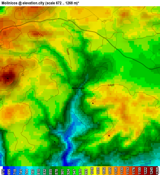
Below is the Elevation map of Molinicos, which displays elevation range with different colors. Scale of the first map is from 672 to 1268 m (2205 to 4160 ft) with average elevation of 975.7 meters (=3201 ft) [note 1]
These maps also provides idea of topography and contour of this city, they are displayed at different zoom levels. More info about maps, scale and edge coordinates you can find below images.
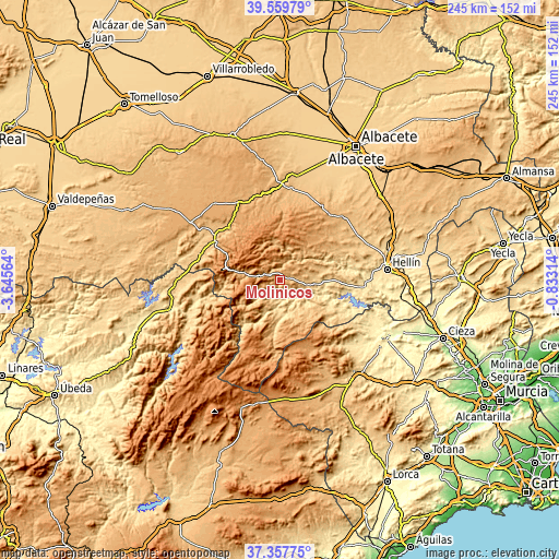
| \ | Map #1 | Topo.Map |
| Scale [m] | 672..1268 m | × |
| Scale [ft] | 2205..4160 ft | × |
| Average | 975.7 m = 3201 ft | × |
| Width | 7.65 km = 4.8 mi | 244.8 km = 152.1 mi |
| Height | 7.65 km = 4.8 mi | 244.8 km = 152.1 mi |
| ↑Max Latitude | 38.501569° | 39.55979° |
| Latitude at center | 38.46717° | 38.46717° |
| ↓Min Latitude | 38.432754° | 37.35775° |
| ← Min Longitude | -2.283335° | -3.64564° |
| Longitude center | -2.23939° | -2.23939° |
| →Max Longitude | -2.195445° | -0.83314° |
Nearby cities:
Cities around Molinicos sort by population:
• Elche de la Sierra elevation 642 m
16.8 km,  96°
96°
• Yeste 912 m
12.9 km,  211°
211°
• Socovos 741 m
26.8 km,  124°
124°
• Liétor 672 m
26.2 km,  71°
71°
• Riópar 984 m
18.7 km,  281°
281°
• Letur 735 m
16.4 km,  133°
133°
• Bogarra 853 m
12.9 km,  10°
10°
• Ayna 712 m
16.4 km,  55°
55°
• Férez 677 m
24.6 km, 121°
• Paterna del Madera 1125 m
17.1 km,  327°
327°
• Villaverde de Guadalimar 796 m
24.3 km,  266°
266°
• Cotillas 936 m
23.5 km,  260°
260°
Multilingual:
 En español:
Molinicos elevación 853 m.
 En France:
Molinicos élévation 853 m.
 Auf Deutsch:
Molinicos höhe über dem Meeresspiegel ist 853 m.

Sources and notes:
- [note 1] Map square and city borders are not equal. Map elevation data is calculated only from area inside that square.
- [src 1] Elevation data from geonames database provided with same terms of usage.
- [src 2] The elevation map of Molinicos is generated using elevation data from NASA's 3 arcsec (90m) resolution SRTM data.
- [src 3] Base (background) map © OpenStreetMap contributors tiles are generated by Geofabrik and OpenTopoMap.
Copyright & License:
This Molinicos Elevation Map is licensed under CC BY-SA. You may reuse any part from this page, if you give a proper credit by linking to this URL:
 More info on terms of use page.