Narboneta elevation
Narboneta (Castille-La Mancha, Provincia de Cuenca), Spain elevation is 871 meters and Narboneta elevation in feet is 2858 ft above sea level [src 1]. Narboneta is a seat of a third-order administrative division (feature code) with elevation that is 268 meters (879 ft) bigger than average city elevation in Spain.
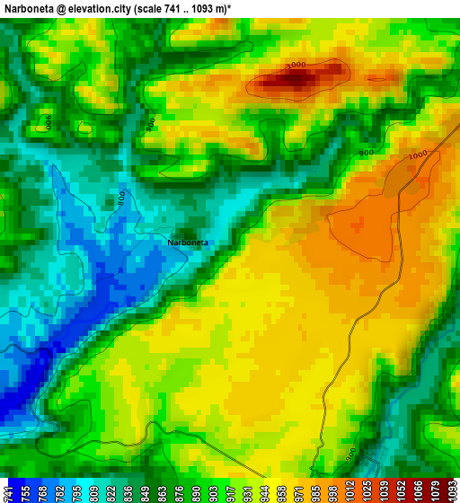
Below is the Elevation map of Narboneta, which displays elevation range with different colors. Scale of the first map is from 741 to 1093 m (2431 to 3586 ft) with average elevation of 903.8 meters (=2965 ft) [note 1]
These maps also provides idea of topography and contour of this city, they are displayed at different zoom levels. More info about maps, scale and edge coordinates you can find below images.
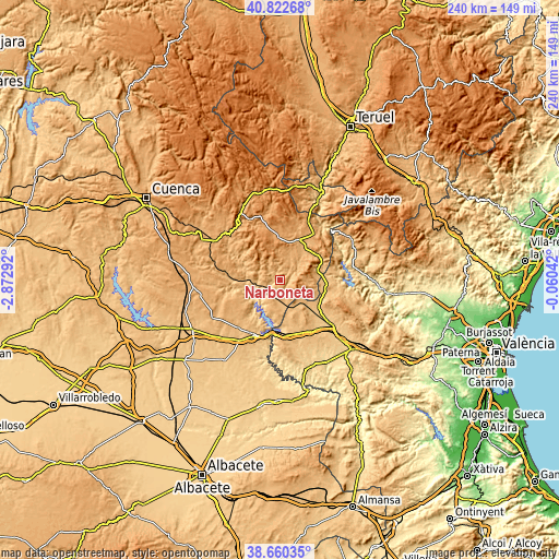
| \ | Map #1 | Topo.Map |
| Scale [m] | 741..1093 m | × |
| Scale [ft] | 2431..3586 ft | × |
| Average | 903.8 m = 2965 ft | × |
| Width | 7.51 km = 4.7 mi | 240.4 km = 149.4 mi |
| Height | 7.51 km = 4.7 mi | 240.4 km = 149.4 mi |
| ↑Max Latitude | 39.783779° | 40.82268° |
| Latitude at center | 39.75° | 39.75° |
| ↓Min Latitude | 39.716205° | 38.66035° |
| ← Min Longitude | -1.510615° | -2.87292° |
| Longitude center | -1.46667° | -1.46667° |
| →Max Longitude | -1.422725° | -0.06042° |
Nearby cities:
Cities around Narboneta sort by population:
• Landete elevation 977 m
18.7 km,  27°
27°
• Camporrobles 919 m
12.5 km,  152°
152°
• Mira 862 m
4.7 km,  142°
142°
• Aliaguilla 996 m
12.1 km,  94°
94°
• Cardenete 966 m
18.6 km,  275°
275°
• Enguídanos 779 m
14.7 km,  230°
230°
• Villar del Humo 975 m
19.3 km,  312°
312°
• Henarejos 1084 m
13.1 km,  353°
353°
• Fuentelespino de Moya 1114 m
18.5 km,  0°
0°
• Garaballa 955 m
11.3 km,  49°
49°
• San Martín de Boniches 1300 m
18.7 km,  332°
332°
• Talayuelas 990 m
19.2 km, 54°
Multilingual:
 En español:
Narboneta elevación 871 m.
 En France:
Narboneta élévation 871 m.
 Auf Deutsch:
Narboneta höhe über dem Meeresspiegel ist 871 m.

Sources and notes:
- [note 1] Map square and city borders are not equal. Map elevation data is calculated only from area inside that square.
- [src 1] Elevation data from geonames database provided with same terms of usage.
- [src 2] The elevation map of Narboneta is generated using elevation data from NASA's 3 arcsec (90m) resolution SRTM data.
- [src 3] Base (background) map © OpenStreetMap contributors tiles are generated by Geofabrik and OpenTopoMap.
Copyright & License:
This Narboneta Elevation Map is licensed under CC BY-SA. You may reuse any part from this page, if you give a proper credit by linking to this URL:
 More info on terms of use page.