Orcera elevation
Orcera (Andalusia, Provincia de Jaén), Spain elevation is 759 meters and Orcera elevation in feet is 2490 ft above sea level [src 1]. Orcera is a seat of a third-order administrative division (feature code) with elevation that is 156 meters (512 ft) bigger than average city elevation in Spain.
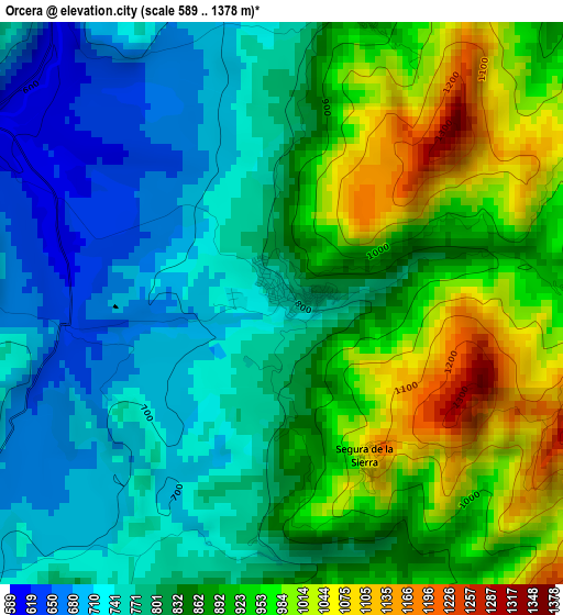
Below is the Elevation map of Orcera, which displays elevation range with different colors. Scale of the first map is from 589 to 1378 m (1932 to 4521 ft) with average elevation of 846.6 meters (=2778 ft) [note 1]
These maps also provides idea of topography and contour of this city, they are displayed at different zoom levels. More info about maps, scale and edge coordinates you can find below images.
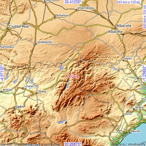
| \ | Map #1 | Topo.Map |
| Scale [m] | 589..1378 m | × |
| Scale [ft] | 1932..4521 ft | × |
| Average | 846.6 m = 2778 ft | × |
| Width | 7.67 km = 4.8 mi | 245.4 km = 152.5 mi |
| Height | 7.67 km = 4.8 mi | 245.3 km = 152.4 mi |
| ↑Max Latitude | 38.351891° | 39.41233° |
| Latitude at center | 38.31742° | 38.31742° |
| ↓Min Latitude | 38.282933° | 37.20573° |
| ← Min Longitude | -2.708815° | -4.07112° |
| Longitude center | -2.66487° | -2.66487° |
| →Max Longitude | -2.620925° | -1.25862° |
Nearby cities:
Cities around Orcera sort by population:
• Beas de Segura elevation 586 m
20.8 km,  249°
249°
• La Puerta de Segura 594 m
7.6 km,  301°
301°
• Arroyo del Ojanco 541 m
20.1 km,  271°
271°
• Puente de Génave 544 m
12.8 km,  289°
289°
• Segura de la Sierra 1071 m
2.4 km,  153°
153°
• Riópar 984 m
27.6 km,  42°
42°
• Bienservida 896 m
22.7 km,  11°
11°
• Génave 820 m
13.9 km,  334°
334°
• Villaverde de Guadalimar 796 m
20 km, 39°
• Cotillas 936 m
18.8 km,  47°
47°
• Siles 840 m
10.8 km, 41°
• Benatae 851 m
4.2 km,  16°
16°
Multilingual:
 En español:
Orcera elevación 759 m.
 En France:
Orcera élévation 759 m.


Sources and notes:
- [note 1] Map square and city borders are not equal. Map elevation data is calculated only from area inside that square.
- [src 1] Elevation data from geonames database provided with same terms of usage.
- [src 2] The elevation map of Orcera is generated using elevation data from NASA's 3 arcsec (90m) resolution SRTM data.
- [src 3] Base (background) map © OpenStreetMap contributors tiles are generated by Geofabrik and OpenTopoMap.
Copyright & License:
This Orcera Elevation Map is licensed under CC BY-SA. You may reuse any part from this page, if you give a proper credit by linking to this URL:
 More info on terms of use page.