Órgiva elevation
Órgiva (Andalusia, Provincia de Granada), Spain elevation is 468 meters and Órgiva elevation in feet is 1535 ft above sea level [src 1]. Órgiva is a populated place (feature code) with elevation that is 135 meters (443 ft) smaller than average city elevation in Spain.
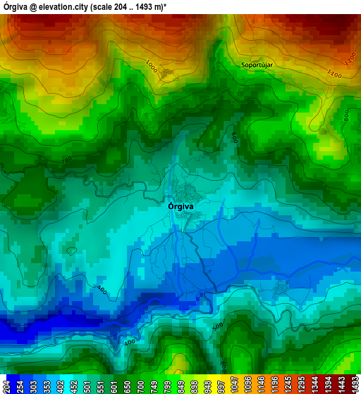
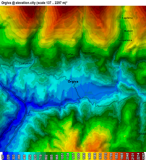
Below is the Elevation map of Órgiva, which displays elevation range with different colors. Scale of the first map is from 204 to 1493 m (669 to 4898 ft) with average elevation of 655.9 meters (=2152 ft) [note 1]
These maps also provides idea of topography and contour of this city, they are displayed at different zoom levels. More info about maps, scale and edge coordinates you can find below images.
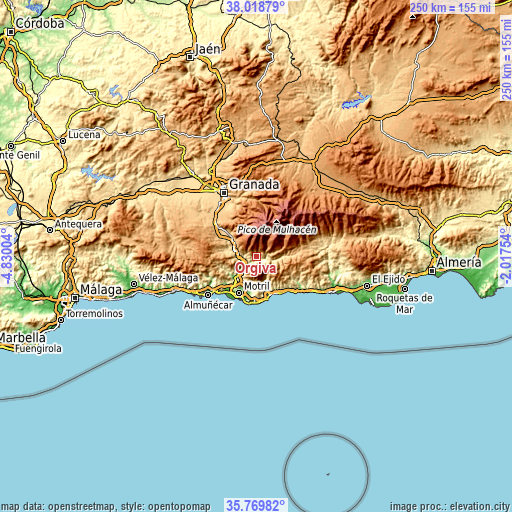
| \ | Map #1 | Map #2 | Topo.Map |
| Scale [m] | 204..1493 m | 137..2297 m | × |
| Scale [ft] | 669..4898 ft | 449..7536 ft | × |
| Average | 655.9 m = 2152 ft | 972.6 m = 3191 ft | × |
| Width | 7.81 km = 4.9 mi | 15.63 km = 9.7 mi | 250.1 km = 155.4 mi |
| Height | 7.81 km = 4.9 mi | 15.63 km = 9.7 mi | 250.1 km = 155.4 mi |
| ↑Max Latitude | 36.937723° | 36.97284° | 38.01879° |
| Latitude at center | 36.90259° | 36.90259° | 36.90259° |
| ↓Min Latitude | 36.867441° | 36.832275° | 35.76982° |
| ← Min Longitude | -3.467735° | -3.511681° | -4.83004° |
| Longitude center | -3.42379° | -3.42379° | -3.42379° |
| →Max Longitude | -3.379845° | -3.335899° | -2.01754° |
Nearby cities:
Cities around Órgiva sort by population:
• Lanjarón elevation 667 m
5.5 km,  288°
288°
• Vélez de Benaudalla 181 m
11.3 km,  226°
226°
• Capileira 1454 m
8.7 km,  41°
41°
• Rubite 791 m
12.3 km,  146°
146°
• Almegíjar 818 m
10.9 km,  90°
90°
• Pórtugos 1304 m
11 km,  66°
66°
• Busquístar 1179 m
12.2 km, 71°
• Cáñar 1025 m
2.7 km,  351°
351°
• Pampaneira 1064 m
7 km,  53°
53°
• Soportújar 950 m
3.3 km,  29°
29°
• Carataunas 734 m
2.6 km, 32°
• Bubión 1322 m
7.9 km, 49°
Multilingual:
 En español:
Órgiva elevación 468 m.
 En France:
Órgiva élévation 468 m.


Sources and notes:
- [note 1] Map square and city borders are not equal. Map elevation data is calculated only from area inside that square.
- [src 1] Elevation data from geonames database provided with same terms of usage.
- [src 2] The elevation map of Órgiva is generated using elevation data from NASA's 3 arcsec (90m) resolution SRTM data.
- [src 3] Base (background) map © OpenStreetMap contributors tiles are generated by Geofabrik and OpenTopoMap.
Copyright & License:
This Órgiva Elevation Map is licensed under CC BY-SA. You may reuse any part from this page, if you give a proper credit by linking to this URL:
 More info on terms of use page.