Pruna elevation
Pruna (Andalusia, Provincia de Sevilla), Spain elevation is 543 meters and Pruna elevation in feet is 1781 ft above sea level [src 1]. Pruna is a seat of a third-order administrative division (feature code) with elevation that is 60 meters (197 ft) smaller than average city elevation in Spain.
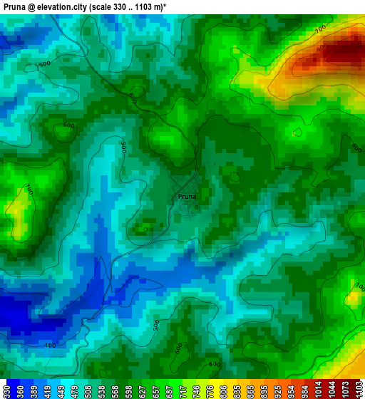
Below is the Elevation map of Pruna, which displays elevation range with different colors. Scale of the first map is from 330 to 1103 m (1083 to 3619 ft) with average elevation of 561.1 meters (=1841 ft) [note 1]
These maps also provides idea of topography and contour of this city, they are displayed at different zoom levels. More info about maps, scale and edge coordinates you can find below images.
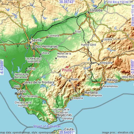
| \ | Map #1 | Topo.Map |
| Scale [m] | 330..1103 m | × |
| Scale [ft] | 1083..3619 ft | × |
| Average | 561.1 m = 1841 ft | × |
| Width | 7.81 km = 4.9 mi | 249.8 km = 155.2 mi |
| Height | 7.81 km = 4.9 mi | 249.8 km = 155.2 mi |
| ↑Max Latitude | 37.007361° | 38.08743° |
| Latitude at center | 36.97226° | 36.97226° |
| ↓Min Latitude | 36.937143° | 35.84051° |
| ← Min Longitude | -5.266245° | -6.62855° |
| Longitude center | -5.2223° | -5.2223° |
| →Max Longitude | -5.178355° | -3.81605° |
Nearby cities:
Cities around Pruna sort by population:
• Olvera elevation 590 m
5.8 km,  223°
223°
• Alcalá del Valle 619 m
8.7 km,  149°
149°
• El Saucejo 545 m
15.7 km,  44°
44°
• Setenil de las Bodegas 555 m
12.6 km,  163°
163°
• Cañete la Real 747 m
17.7 km,  97°
97°
• Almargen 511 m
18.1 km,  79°
79°
• El Gastor 599 m
15.9 km,  214°
214°
• Cuevas del Becerro 732 m
19.1 km,  124°
124°
• Villanueva de San Juan 468 m
9.5 km,  25°
25°
• Algámitas 421 m
8 km,  53°
53°
• Torre Alháquime 469 m
6.4 km,  189°
189°
• Montecorto 500 m
18.7 km,  201°
201°
Multilingual:
 En español:
Pruna elevación 543 m.
 En France:
Pruna élévation 543 m.


Sources and notes:
- [note 1] Map square and city borders are not equal. Map elevation data is calculated only from area inside that square.
- [src 1] Elevation data from geonames database provided with same terms of usage.
- [src 2] The elevation map of Pruna is generated using elevation data from NASA's 3 arcsec (90m) resolution SRTM data.
- [src 3] Base (background) map © OpenStreetMap contributors tiles are generated by Geofabrik and OpenTopoMap.
Copyright & License:
This Pruna Elevation Map is licensed under CC BY-SA. You may reuse any part from this page, if you give a proper credit by linking to this URL:
 More info on terms of use page.