San Isidro elevation
San Isidro (Canary Islands, Provincia de Santa Cruz de Tenerife), Spain elevation is 207 meters and San Isidro elevation in feet is 679 ft above sea level [src 1]. San Isidro is a populated place (feature code) with elevation that is 396 meters (1299 ft) smaller than average city elevation in Spain.
Below is the Elevation map of San Isidro, which displays elevation range with different colors. Scale of the first map is from -3 to 706 m (-10 to 2316 ft) with average elevation of 222.6 meters (=730 ft) [note 1]
These maps also provides idea of topography and contour of this city, they are displayed at different zoom levels. More info about maps, scale and edge coordinates you can find below images.
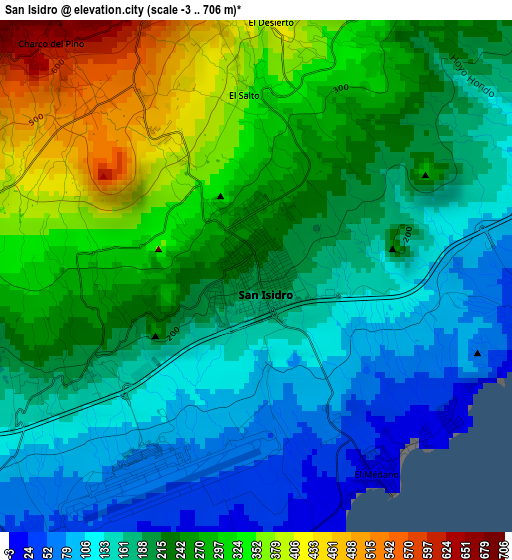
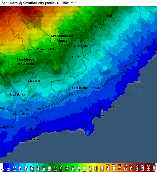
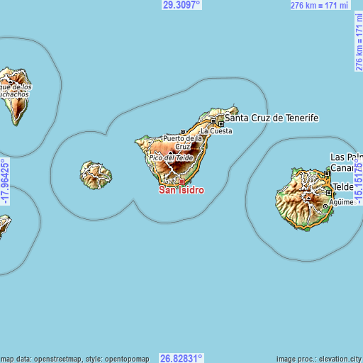
| \ | Map #1 | Map #2 | Topo.Map |
| Scale [m] | -3..706 m | -4..1501 m | × |
| Scale [ft] | -10..2316 ft | -13..4925 ft | × |
| Average | 222.6 m = 730 ft | 374.5 m = 1229 ft | × |
| Width | 8.62 km = 5.4 mi | 17.25 km = 10.7 mi | 275.9 km = 171.4 mi |
| Height | 8.62 km = 5.4 mi | 17.25 km = 10.7 mi | 275.9 km = 171.4 mi |
| ↑Max Latitude | 28.114937° | 28.15369° | 29.3097° |
| Latitude at center | 28.07617° | 28.07617° | 28.07617° |
| ↓Min Latitude | 28.037389° | 27.998594° | 26.82831° |
| ← Min Longitude | -16.601945° | -16.645891° | -17.96425° |
| Longitude center | -16.558° | -16.558° | -16.558° |
| →Max Longitude | -16.514055° | -16.470109° | -15.15175° |
Nearby cities:
Cities around San Isidro sort by population:
• Arona elevation 632 m
12.3 km,  282°
282°
• Adeje 284 m
17.3 km,  287°
287°
• Granadilla de Abona 634 m
5.1 km,  339°
339°
• Guía de Isora 594 m
26.4 km,  304°
304°
• Güimar 278 m
29.8 km,  28°
28°
• San Miguel De Abona 601 m
6.3 km, 292°
• Lomo de Arico 401 m
12.4 km,  36°
36°
• Arafo 500 m
32.2 km,  24°
24°
• Playa de las Américas 14 m
16.9 km,  265°
265°
• Fasnia 429 m
21.3 km, 33°
• Las Rosas 20 m
11.6 km,  234°
234°
• Vilaflor 1364 m
11.7 km,  319°
319°
Multilingual:
 En español:
San Isidro elevación 207 m.
 En France:
San Isidro élévation 207 m.
 Auf Deutsch:
San Isidro höhe über dem Meeresspiegel ist 207 m.

Sources and notes:
- [note 1] Map square and city borders are not equal. Map elevation data is calculated only from area inside that square.
- [src 1] Elevation data from geonames database provided with same terms of usage.
- [src 2] The elevation map of San Isidro is generated using elevation data from NASA's 3 arcsec (90m) resolution SRTM data.
- [src 3] Base (background) map © OpenStreetMap contributors tiles are generated by Geofabrik and OpenTopoMap.
Copyright & License:
This San Isidro Elevation Map is licensed under CC BY-SA. You may reuse any part from this page, if you give a proper credit by linking to this URL:
 More info on terms of use page.