Talarrubias elevation
Talarrubias (Extremadura, Provincia de Badajoz), Spain elevation is 440 meters and Talarrubias elevation in feet is 1444 ft above sea level [src 1]. Talarrubias is a seat of a third-order administrative division (feature code) with elevation that is 163 meters (535 ft) smaller than average city elevation in Spain.
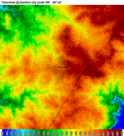
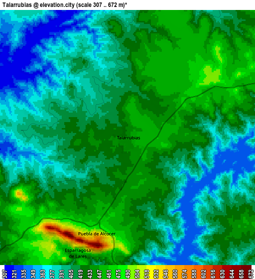
Below is the Elevation map of Talarrubias, which displays elevation range with different colors. Scale of the first map is from 340 to 467 m (1115 to 1532 ft) with average elevation of 424.7 meters (=1393 ft) [note 1]
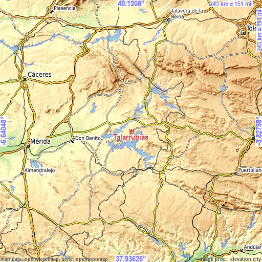
These maps also provides idea of topography and contour of this city, they are displayed at different zoom levels. More info about maps, scale and edge coordinates you can find below images.
| \ | Map #1 | Map #2 | Topo.Map |
| Scale [m] | 340..467 m | 307..672 m | × |
| Scale [ft] | 1115..1532 ft | 1007..2205 ft | × |
| Average | 424.7 m = 1393 ft | 414.7 m = 1361 ft | × |
| Width | 7.59 km = 4.7 mi | 15.18 km = 9.4 mi | 242.9 km = 150.9 mi |
| Height | 7.59 km = 4.7 mi | 15.18 km = 9.4 mi | 242.9 km = 150.9 mi |
| ↑Max Latitude | 39.071096° | 39.105205° | 40.1208° |
| Latitude at center | 39.03697° | 39.03697° | 39.03697° |
| ↓Min Latitude | 39.002828° | 38.968669° | 37.93626° |
| ← Min Longitude | -5.278175° | -5.322121° | -6.64048° |
| Longitude center | -5.23423° | -5.23423° | -5.23423° |
| →Max Longitude | -5.190285° | -5.146339° | -3.82798° |
Nearby cities:
Cities around Talarrubias sort by population:
• Navalvillar de Pela elevation 336 m
21.2 km,  287°
287°
• Herrera del Duque 461 m
21.6 km,  47°
47°
• Orellana la Vieja 356 m
26.2 km,  262°
262°
• Siruela 520 m
17.3 km,  112°
112°
• Casas de Don Pedro 376 m
11.5 km,  313°
313°
• Peñalsordo 423 m
26.2 km,  156°
156°
• Puebla de Alcocer 502 m
5.9 km,  198°
198°
• Valdecaballeros 406 m
23.2 km,  9°
9°
• Esparragosa de Lares 471 m
7.5 km, 204°
• Garlitos 539 m
23.8 km,  137°
137°
• Garbayuela 488 m
20.4 km,  86°
86°
• Tamurejo 570 m
26.7 km,  102°
102°
Multilingual:
 En español:
Talarrubias elevación 440 m.
 En France:
Talarrubias élévation 440 m.
 Auf Deutsch:
Talarrubias höhe über dem Meeresspiegel ist 440 m.

Sources and notes:
- [note 1] Map square and city borders are not equal. Map elevation data is calculated only from area inside that square.
- [src 1] Elevation data from geonames database provided with same terms of usage.
- [src 2] The elevation map of Talarrubias is generated using elevation data from NASA's 3 arcsec (90m) resolution SRTM data.
- [src 3] Base (background) map © OpenStreetMap contributors tiles are generated by Geofabrik and OpenTopoMap.
Copyright & License:
This Talarrubias Elevation Map is licensed under CC BY-SA. You may reuse any part from this page, if you give a proper credit by linking to this URL:
 More info on terms of use page.