Tarifa elevation
Tarifa (Andalusia, Provincia de Cádiz), Spain elevation is 22 meters and Tarifa elevation in feet is 72 ft above sea level [src 1]. Tarifa is a seat of a third-order administrative division (feature code) with elevation that is 581 meters (1906 ft) smaller than average city elevation in Spain.
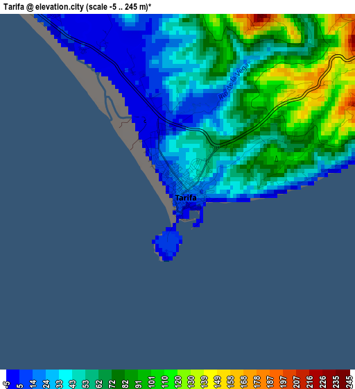
Below is the Elevation map of Tarifa, which displays elevation range with different colors. Scale of the first map is from -5 to 245 m (-16 to 804 ft) with average elevation of 59.8 meters (=196 ft) [note 1]
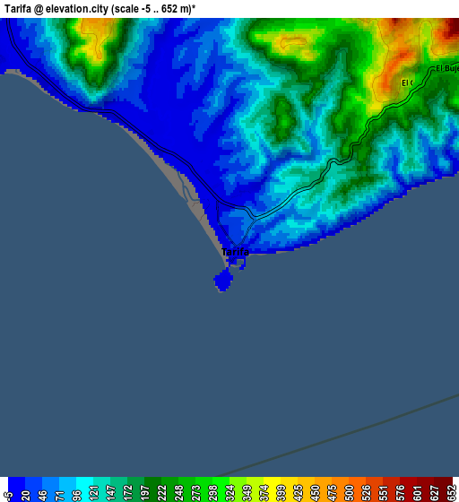
These maps also provides idea of topography and contour of this city, they are displayed at different zoom levels. More info about maps, scale and edge coordinates you can find below images.
| \ | Map #1 | Map #2 | Topo.Map |
| Scale [m] | -5..245 m | -5..652 m | × |
| Scale [ft] | -16..804 ft | -16..2139 ft | × |
| Average | 59.8 m = 196 ft | 141.2 m = 463 ft | × |
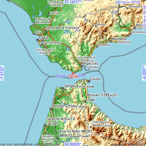
| Width | 7.9 km = 4.9 mi | 15.81 km = 9.8 mi | 252.9 km = 157.1 mi |
| Height | 7.9 km = 4.9 mi | 15.81 km = 9.8 mi | 252.9 km = 157.1 mi |
| ↑Max Latitude | 36.049468° | 36.08499° | 37.14317° |
| Latitude at center | 36.01393° | 36.01393° | 36.01393° |
| ↓Min Latitude | 35.978376° | 35.942806° | 34.86828° |
| ← Min Longitude | -5.650895° | -5.694841° | -7.0132° |
| Longitude center | -5.60695° | -5.60695° | -5.60695° |
| →Max Longitude | -5.563005° | -5.519059° | -4.2007° |
Nearby cities:
Cities around Tarifa sort by population:
• Algeciras elevation 29 m
19.3 km,  46°
46°
• Ceuta 10 m
29.3 km,  118°
118°
• La Línea de la Concepción 4 m
28.9 km, 53°
• San Roque 105 m
29.6 km,  42°
42°
• Barbate 18 m
34.6 km,  305°
305°
• Los Barrios 23 m
21.6 km,  28°
28°
• Vejer de la Frontera 221 m
41.8 km, 309°
• Benalup-Casas Viejas 116 m
41.1 km,  333°
333°
• Castellar de la Frontera 220 m
36.4 km,  22°
22°
• Benzú 3 m
23.7 km, 117°
• Zahara de los Atunes 4 m
25.5 km,  302°
302°
• San Enrique de Guadiaro 99 m
43 km, 41°
Multilingual:
 En español:
Tarifa elevación 22 m.
 En France:
Tarifa élévation 22 m.


Sources and notes:
- [note 1] Map square and city borders are not equal. Map elevation data is calculated only from area inside that square.
- [src 1] Elevation data from geonames database provided with same terms of usage.
- [src 2] The elevation map of Tarifa is generated using elevation data from NASA's 3 arcsec (90m) resolution SRTM data.
- [src 3] Base (background) map © OpenStreetMap contributors tiles are generated by Geofabrik and OpenTopoMap.
Copyright & License:
This Tarifa Elevation Map is licensed under CC BY-SA. You may reuse any part from this page, if you give a proper credit by linking to this URL:
 More info on terms of use page.