Teba elevation
Teba (Andalusia, Provincia de Málaga), Spain elevation is 547 meters and Teba elevation in feet is 1795 ft above sea level [src 1]. Teba is a seat of a third-order administrative division (feature code) with elevation that is 56 meters (184 ft) smaller than average city elevation in Spain.
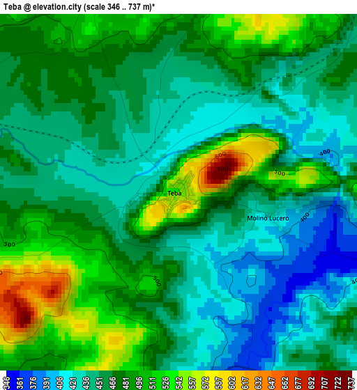
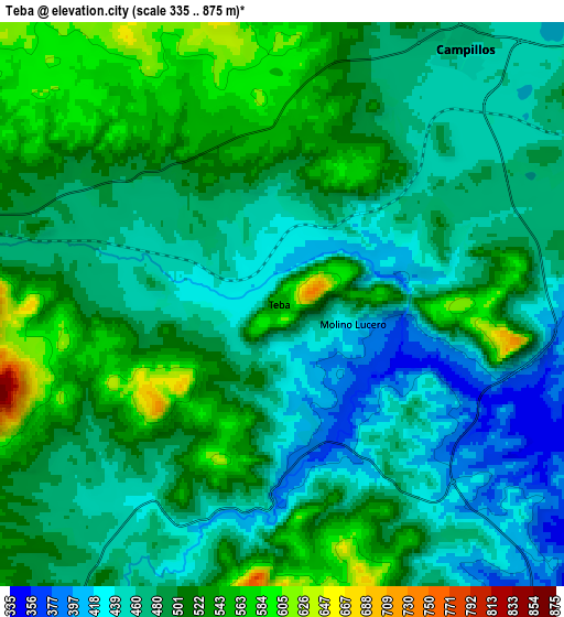
Below is the Elevation map of Teba, which displays elevation range with different colors. Scale of the first map is from 346 to 737 m (1135 to 2418 ft) with average elevation of 468.4 meters (=1537 ft) [note 1]
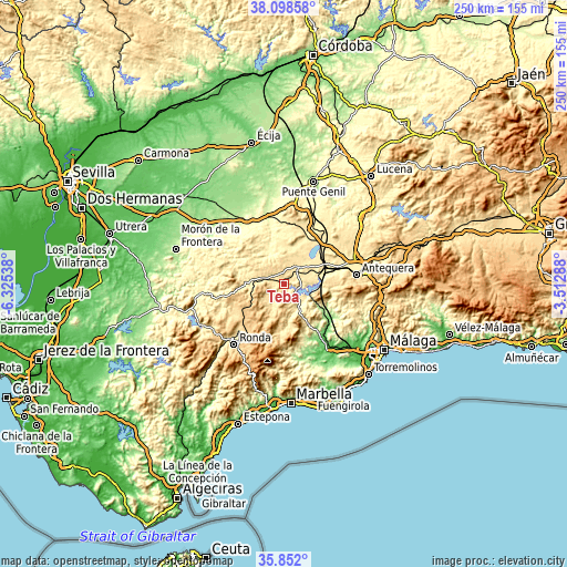
These maps also provides idea of topography and contour of this city, they are displayed at different zoom levels. More info about maps, scale and edge coordinates you can find below images.
| \ | Map #1 | Map #2 | Topo.Map |
| Scale [m] | 346..737 m | 335..875 m | × |
| Scale [ft] | 1135..2418 ft | 1099..2871 ft | × |
| Average | 468.4 m = 1537 ft | 490.2 m = 1608 ft | × |
| Width | 7.81 km = 4.9 mi | 15.61 km = 9.7 mi | 249.8 km = 155.2 mi |
| Height | 7.81 km = 4.9 mi | 15.61 km = 9.7 mi | 249.8 km = 155.2 mi |
| ↑Max Latitude | 37.018676° | 37.053755° | 38.09858° |
| Latitude at center | 36.98358° | 36.98358° | 36.98358° |
| ↓Min Latitude | 36.948468° | 36.91334° | 35.852° |
| ← Min Longitude | -4.963075° | -5.007021° | -6.32538° |
| Longitude center | -4.91913° | -4.91913° | -4.91913° |
| →Max Longitude | -4.875185° | -4.831239° | -3.51288° |
Nearby cities:
Cities around Teba sort by population:
• Campillos elevation 470 m
8.7 km,  34°
34°
• El Saucejo 545 m
18.7 km,  301°
301°
• Los Corrales 377 m
14.1 km,  335°
335°
• Sierra de Yeguas 454 m
16.3 km,  16°
16°
• Martín de la Jara 408 m
14.5 km, 344°
• Ardales 405 m
13.4 km,  151°
151°
• Cañete la Real 747 m
10 km,  249°
249°
• Almargen 511 m
9.3 km,  282°
282°
• Cuevas del Becerro 732 m
16.4 km,  222°
222°
• Algámitas 421 m
20.8 km, 279°
• Carratraca 531 m
17 km, 148°
• Serrato 531 m
12.2 km,  206°
206°
Multilingual:
 En español:
Teba elevación 547 m.
 En France:
Teba élévation 547 m.


Sources and notes:
- [note 1] Map square and city borders are not equal. Map elevation data is calculated only from area inside that square.
- [src 1] Elevation data from geonames database provided with same terms of usage.
- [src 2] The elevation map of Teba is generated using elevation data from NASA's 3 arcsec (90m) resolution SRTM data.
- [src 3] Base (background) map © OpenStreetMap contributors tiles are generated by Geofabrik and OpenTopoMap.
Copyright & License:
This Teba Elevation Map is licensed under CC BY-SA. You may reuse any part from this page, if you give a proper credit by linking to this URL:
 More info on terms of use page.