Terrinches elevation
Terrinches (Castille-La Mancha, Provincia de Ciudad Real), Spain elevation is 949 meters and Terrinches elevation in feet is 3114 ft above sea level [src 1]. Terrinches is a seat of a third-order administrative division (feature code) with elevation that is 346 meters (1135 ft) bigger than average city elevation in Spain.
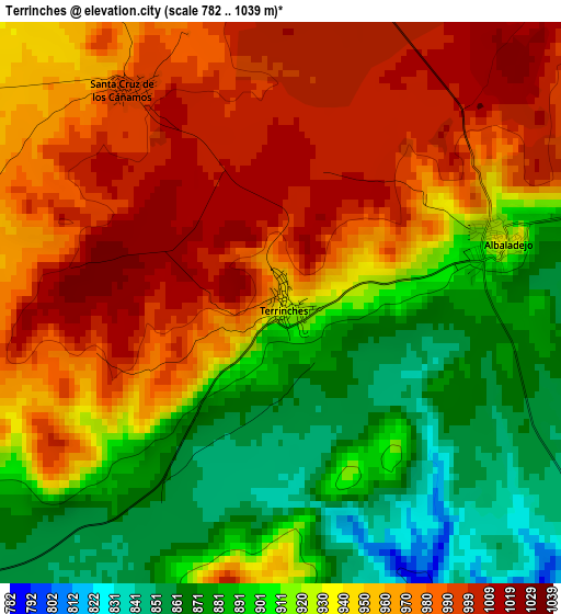
Below is the Elevation map of Terrinches, which displays elevation range with different colors. Scale of the first map is from 782 to 1039 m (2566 to 3409 ft) with average elevation of 936.7 meters (=3073 ft) [note 1]
These maps also provides idea of topography and contour of this city, they are displayed at different zoom levels. More info about maps, scale and edge coordinates you can find below images.
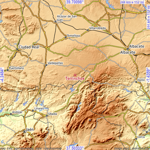
| \ | Map #1 | Topo.Map |
| Scale [m] | 782..1039 m | × |
| Scale [ft] | 2566..3409 ft | × |
| Average | 936.7 m = 3073 ft | × |
| Width | 7.64 km = 4.7 mi | 244.4 km = 151.9 mi |
| Height | 7.64 km = 4.7 mi | 244.4 km = 151.9 mi |
| ↑Max Latitude | 38.644901° | 39.70098° |
| Latitude at center | 38.61057° | 38.61057° |
| ↓Min Latitude | 38.576223° | 37.50333° |
| ← Min Longitude | -2.886095° | -4.2484° |
| Longitude center | -2.84215° | -2.84215° |
| →Max Longitude | -2.798205° | -1.4359° |
Nearby cities:
Cities around Terrinches sort by population:
• Infantes elevation 885 m
20.4 km,  313°
313°
• Villanueva de la Fuente 1006 m
15.7 km,  53°
53°
• Villahermosa 959 m
15.7 km,  350°
350°
• Montiel 894 m
9.9 km, 348°
• Albaladejo 924 m
3.1 km,  72°
72°
• Villamanrique 855 m
15.3 km,  242°
242°
• Torre de Juan Abad 829 m
19.2 km,  261°
261°
• Puebla del Príncipe 940 m
8.7 km, 236°
• Villapalacios 842 m
18.5 km,  102°
102°
• Almedina 909 m
9.8 km,  279°
279°
• Santa Cruz de los Cáñamos 991 m
3.7 km,  325°
325°
• Fuenllana 910 m
19 km, 328°
Multilingual:
 En español:
Terrinches elevación 949 m.
 En France:
Terrinches élévation 949 m.
 Auf Deutsch:
Terrinches höhe über dem Meeresspiegel ist 949 m.

Sources and notes:
- [note 1] Map square and city borders are not equal. Map elevation data is calculated only from area inside that square.
- [src 1] Elevation data from geonames database provided with same terms of usage.
- [src 2] The elevation map of Terrinches is generated using elevation data from NASA's 3 arcsec (90m) resolution SRTM data.
- [src 3] Base (background) map © OpenStreetMap contributors tiles are generated by Geofabrik and OpenTopoMap.
Copyright & License:
This Terrinches Elevation Map is licensed under CC BY-SA. You may reuse any part from this page, if you give a proper credit by linking to this URL:
 More info on terms of use page.