Villarrasa elevation
Villarrasa (Andalusia, Provincia de Huelva), Spain elevation is 68 meters and Villarrasa elevation in feet is 223 ft above sea level [src 1]. Villarrasa is a seat of a third-order administrative division (feature code) with elevation that is 535 meters (1755 ft) smaller than average city elevation in Spain.
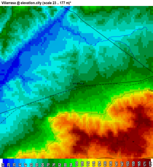
Below is the Elevation map of Villarrasa, which displays elevation range with different colors. Scale of the first map is from 23 to 177 m (75 to 581 ft) with average elevation of 81.4 meters (=267 ft) [note 1]
These maps also provides idea of topography and contour of this city, they are displayed at different zoom levels. More info about maps, scale and edge coordinates you can find below images.
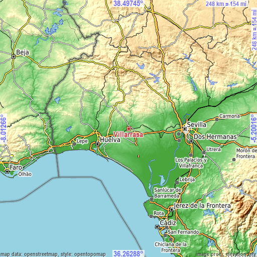
| \ | Map #1 | Topo.Map |
| Scale [m] | 23..177 m | × |
| Scale [ft] | 75..581 ft | × |
| Average | 81.4 m = 267 ft | × |
| Width | 7.76 km = 4.8 mi | 248.5 km = 154.4 mi |
| Height | 7.76 km = 4.8 mi | 248.5 km = 154.4 mi |
| ↑Max Latitude | 37.423398° | 38.49745° |
| Latitude at center | 37.38849° | 37.38849° |
| ↓Min Latitude | 37.353566° | 36.26288° |
| ← Min Longitude | -6.650355° | -8.01266° |
| Longitude center | -6.60641° | -6.60641° |
| →Max Longitude | -6.562465° | -5.20016° |
Nearby cities:
Cities around Villarrasa sort by population:
• Almonte elevation 74 m
15.9 km,  150°
150°
• Bollullos par del Condado 129 m
7.9 km,  131°
131°
• La Palma del Condado 99 m
4.8 km,  93°
93°
• Bonares 87 m
9.7 km,  222°
222°
• Beas 121 m
17 km,  284°
284°
• Niebla 41 m
7 km,  245°
245°
• Paterna del Campo 175 m
18.3 km,  79°
79°
• Villalba del Alcor 161 m
11.7 km, 85°
• Lucena del Puerto 87 m
14.4 km,  229°
229°
• Manzanilla 169 m
15.3 km, 89°
• Escacena del Campo 163 m
19.4 km, 83°
• Chucena 147 m
19.1 km,  98°
98°
Multilingual:
 En español:
Villarrasa elevación 68 m.
 En France:
Villarrasa élévation 68 m.
 Auf Deutsch:
Villarrasa höhe über dem Meeresspiegel ist 68 m.

Sources and notes:
- [note 1] Map square and city borders are not equal. Map elevation data is calculated only from area inside that square.
- [src 1] Elevation data from geonames database provided with same terms of usage.
- [src 2] The elevation map of Villarrasa is generated using elevation data from NASA's 3 arcsec (90m) resolution SRTM data.
- [src 3] Base (background) map © OpenStreetMap contributors tiles are generated by Geofabrik and OpenTopoMap.
Copyright & License:
This Villarrasa Elevation Map is licensed under CC BY-SA. You may reuse any part from this page, if you give a proper credit by linking to this URL:
 More info on terms of use page.