Villatoya elevation
Villatoya (Castille-La Mancha, Provincia de Albacete), Spain elevation is 395 meters and Villatoya elevation in feet is 1296 ft above sea level [src 1]. Villatoya is a seat of a third-order administrative division (feature code) with elevation that is 208 meters (682 ft) smaller than average city elevation in Spain.
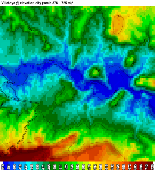
Below is the Elevation map of Villatoya, which displays elevation range with different colors. Scale of the first map is from 378 to 725 m (1240 to 2379 ft) with average elevation of 497.4 meters (=1632 ft) [note 1]
These maps also provides idea of topography and contour of this city, they are displayed at different zoom levels. More info about maps, scale and edge coordinates you can find below images.
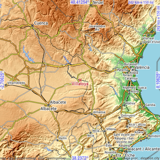
| \ | Map #1 | Topo.Map |
| Scale [m] | 378..725 m | × |
| Scale [ft] | 1240..2379 ft | × |
| Average | 497.4 m = 1632 ft | × |
| Width | 7.56 km = 4.7 mi | 241.9 km = 150.3 mi |
| Height | 7.56 km = 4.7 mi | 241.9 km = 150.3 mi |
| ↑Max Latitude | 39.367312° | 40.41254° |
| Latitude at center | 39.33333° | 39.33333° |
| ↓Min Latitude | 39.299331° | 38.2372° |
| ← Min Longitude | -1.343945° | -2.70625° |
| Longitude center | -1.3° | -1.3° |
| →Max Longitude | -1.256055° | 0.10625° |
Nearby cities:
Cities around Villatoya sort by population:
• Requena elevation 699 m
24.3 km,  44°
44°
• Casas Ibáñez 705 m
15.4 km,  248°
248°
• Villamalea 737 m
24.6 km,  278°
278°
• Fuentealbilla 660 m
22.8 km, 250°
• Venta del Moro 754 m
17.2 km,  345°
345°
• Alcalá del Júcar 570 m
19.2 km,  215°
215°
• Abengibre 651 m
23.9 km,  237°
237°
• Cofrentes 373 m
23.6 km,  119°
119°
• Casas de Ves 696 m
9.7 km,  197°
197°
• Alborea 723 m
9.1 km,  232°
232°
• Balsa de Ves 736 m
11.4 km,  130°
130°
• Villa de Ves 674 m
15.9 km,  158°
158°
Multilingual:
 En español:
Villatoya elevación 395 m.
 En France:
Villatoya élévation 395 m.
 Auf Deutsch:
Villatoya höhe über dem Meeresspiegel ist 395 m.

Sources and notes:
- [note 1] Map square and city borders are not equal. Map elevation data is calculated only from area inside that square.
- [src 1] Elevation data from geonames database provided with same terms of usage.
- [src 2] The elevation map of Villatoya is generated using elevation data from NASA's 3 arcsec (90m) resolution SRTM data.
- [src 3] Base (background) map © OpenStreetMap contributors tiles are generated by Geofabrik and OpenTopoMap.
Copyright & License:
This Villatoya Elevation Map is licensed under CC BY-SA. You may reuse any part from this page, if you give a proper credit by linking to this URL:
 More info on terms of use page.