Viveros elevation
Viveros (Castille-La Mancha, Provincia de Albacete), Spain elevation is 1005 meters and Viveros elevation in feet is 3297 ft above sea level [src 1]. Viveros is a seat of a third-order administrative division (feature code) with elevation that is 402 meters (1319 ft) bigger than average city elevation in Spain.
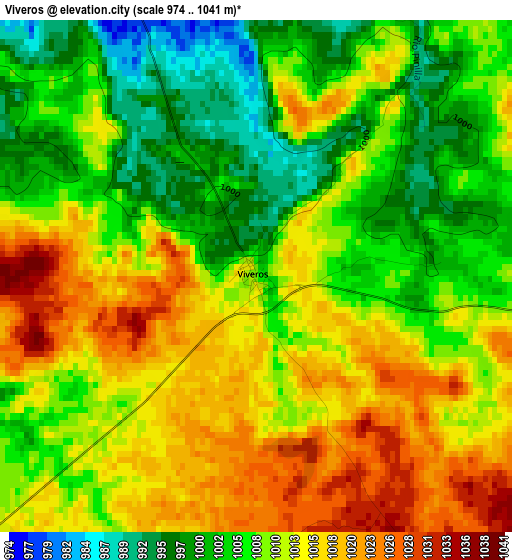
Below is the Elevation map of Viveros, which displays elevation range with different colors. Scale of the first map is from 974 to 1041 m (3196 to 3415 ft) with average elevation of 1009.8 meters (=3313 ft) [note 1]
These maps also provides idea of topography and contour of this city, they are displayed at different zoom levels. More info about maps, scale and edge coordinates you can find below images.
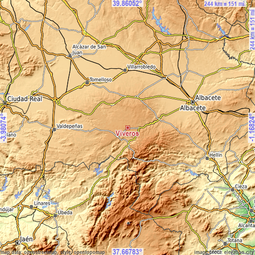
| \ | Map #1 | Topo.Map |
| Scale [m] | 974..1041 m | × |
| Scale [ft] | 3196..3415 ft | × |
| Average | 1009.8 m = 3313 ft | × |
| Width | 7.62 km = 4.7 mi | 243.8 km = 151.5 mi |
| Height | 7.62 km = 4.7 mi | 243.8 km = 151.5 mi |
| ↑Max Latitude | 38.806853° | 39.86052° |
| Latitude at center | 38.7726° | 38.7726° |
| ↓Min Latitude | 38.73833° | 37.66783° |
| ← Min Longitude | -2.618435° | -3.98074° |
| Longitude center | -2.57449° | -2.57449° |
| →Max Longitude | -2.530545° | -1.16824° |
Nearby cities:
Cities around Viveros sort by population:
• El Bonillo elevation 1069 m
20 km,  8°
8°
• Ossa de Montiel 914 m
25.9 km,  325°
325°
• Villanueva de la Fuente 1006 m
13.7 km,  230°
230°
• Villahermosa 959 m
25.8 km,  264°
264°
• Alcaraz 952 m
13.8 km,  148°
148°
• Montiel 894 m
26.5 km,  251°
251°
• Albaladejo 924 m
26.5 km, 229°
• Villapalacios 842 m
22.6 km,  193°
193°
• Povedilla 867 m
8.4 km,  196°
196°
• Salobre 921 m
20.1 km,  174°
174°
• Robledo 1030 m
10.9 km,  98°
98°
• Masegoso 1107 m
23.2 km,  105°
105°
Multilingual:
 En español:
Viveros elevación 1005 m.
 En France:
Viveros élévation 1005 m.
 Auf Deutsch:
Viveros höhe über dem Meeresspiegel ist 1005 m.

Sources and notes:
- [note 1] Map square and city borders are not equal. Map elevation data is calculated only from area inside that square.
- [src 1] Elevation data from geonames database provided with same terms of usage.
- [src 2] The elevation map of Viveros is generated using elevation data from NASA's 3 arcsec (90m) resolution SRTM data.
- [src 3] Base (background) map © OpenStreetMap contributors tiles are generated by Geofabrik and OpenTopoMap.
Copyright & License:
This Viveros Elevation Map is licensed under CC BY-SA. You may reuse any part from this page, if you give a proper credit by linking to this URL:
 More info on terms of use page.