Yémeda elevation
Yémeda (Castille-La Mancha, Provincia de Cuenca), Spain elevation is 922 meters and Yémeda elevation in feet is 3025 ft above sea level [src 1]. Yémeda is a seat of a third-order administrative division (feature code) with elevation that is 319 meters (1047 ft) bigger than average city elevation in Spain.
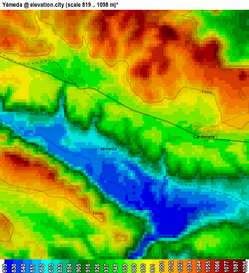
Below is the Elevation map of Yémeda, which displays elevation range with different colors. Scale of the first map is from 819 to 1098 m (2687 to 3602 ft) with average elevation of 956.8 meters (=3139 ft) [note 1]
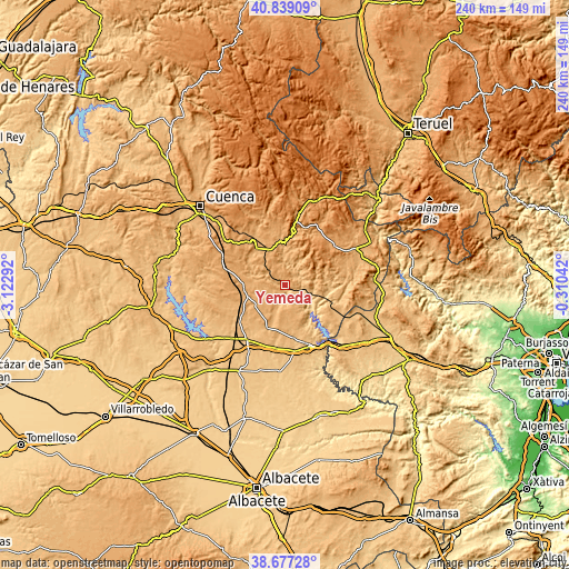
These maps also provides idea of topography and contour of this city, they are displayed at different zoom levels. More info about maps, scale and edge coordinates you can find below images.
| \ | Map #1 | Topo.Map |
| Scale [m] | 819..1098 m | × |
| Scale [ft] | 2687..3602 ft | × |
| Average | 956.8 m = 3139 ft | × |
| Width | 7.51 km = 4.7 mi | 240.4 km = 149.4 mi |
| Height | 7.51 km = 4.7 mi | 240.4 km = 149.4 mi |
| ↑Max Latitude | 39.800441° | 40.83909° |
| Latitude at center | 39.76667° | 39.76667° |
| ↓Min Latitude | 39.732883° | 38.67728° |
| ← Min Longitude | -1.760615° | -3.12292° |
| Longitude center | -1.71667° | -1.71667° |
| →Max Longitude | -1.672725° | -0.31042° |
Nearby cities:
Cities around Yémeda sort by population:
• Campillo de Altobuey elevation 904 m
19.9 km,  201°
201°
• Carboneras de Guadazaón 1083 m
14.8 km,  331°
331°
• Cardenete 966 m
2.8 km,  90°
90°
• Almodóvar del Pinar 986 m
15.3 km,  248°
248°
• Enguídanos 779 m
14.9 km,  138°
138°
• Villar del Humo 975 m
13.2 km,  32°
32°
• Monteagudo de las Salinas 948 m
16.1 km,  283°
283°
• Arguisuelas 1028 m
11.3 km,  310°
310°
• Paracuellos 922 m
8 km,  225°
225°
• Reíllo 974 m
19.6 km,  319°
319°
• Pajaroncillo 975 m
20.4 km,  356°
356°
• San Martín de Boniches 1300 m
19.6 km,  40°
40°
Multilingual:
 En español:
Yémeda elevación 922 m.
 En France:
Yémeda élévation 922 m.


Sources and notes:
- [note 1] Map square and city borders are not equal. Map elevation data is calculated only from area inside that square.
- [src 1] Elevation data from geonames database provided with same terms of usage.
- [src 2] The elevation map of Yémeda is generated using elevation data from NASA's 3 arcsec (90m) resolution SRTM data.
- [src 3] Base (background) map © OpenStreetMap contributors tiles are generated by Geofabrik and OpenTopoMap.
Copyright & License:
This Yémeda Elevation Map is licensed under CC BY-SA. You may reuse any part from this page, if you give a proper credit by linking to this URL:
 More info on terms of use page.