Idfū elevation
Idfū (Aswan), Egypt elevation is 90 meters and Idfū elevation in feet is 295 ft above sea level [src 1]. Idfū is a populated place (feature code) with elevation that is 46 meters (151 ft) bigger than average city elevation in Egypt.
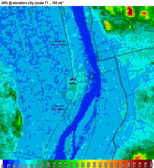
Below is the Elevation map of Idfū, which displays elevation range with different colors. Scale of the first map is from 71 to 183 m (233 to 600 ft) with average elevation of 88.6 meters (=291 ft) [note 1]
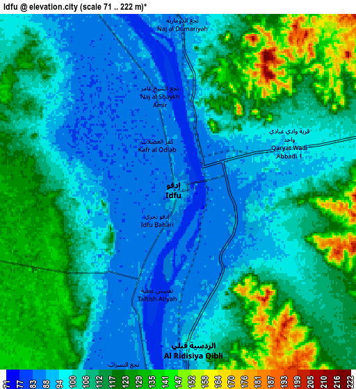
These maps also provides idea of topography and contour of this city, they are displayed at different zoom levels. More info about maps, scale and edge coordinates you can find below images.
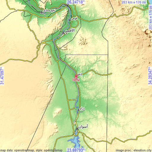
| \ | Map #1 | Map #2 | Topo.Map |
| Scale [m] | 71..183 m | 71..222 m | × |
| Scale [ft] | 233..600 ft | 233..728 ft | × |
| Average | 88.6 m = 291 ft | 107.7 m = 353 ft | × |
| Width | 8.86 km = 5.5 mi | 17.72 km = 11 mi | 283.5 km = 176.2 mi |
| Height | 8.86 km = 5.5 mi | 17.72 km = 11 mi | 283.5 km = 176.2 mi |
| ↑Max Latitude | 25.018988° | 25.058804° | 26.24718° |
| Latitude at center | 24.97916° | 24.97916° | 24.97916° |
| ↓Min Latitude | 24.939319° | 24.899465° | 23.69793° |
| ← Min Longitude | 32.833275° | 32.789329° | 31.47097° |
| Longitude center | 32.87722° | 32.87722° | 32.87722° |
| →Max Longitude | 32.921165° | 32.965111° | 34.28347° |
Nearby cities:
Cities around Idfū sort by population:
• Luxor elevation 89 m
83.4 km,  343°
343°
• Aswan 99 m
98.8 km,  178°
178°
• Qinā 80 m
132.6 km,  353°
353°
• Jirjā 70 m
180.5 km,  326°
326°
• Isnā 86 m
47.7 km,  317°
317°
• Kousa 76 m
104.7 km, 353°
• Kawm Umbū 108 m
56.3 km,  172°
172°
• Dishnā 75 m
133.6 km, 342°
• Farshūţ 78 m
139.4 km, 329°
• Al Balyanā 75 m
164.9 km, 327°
• Naja' Ḥammādī 78 m
135 km, 331°
• Al Quşayr 21 m
188.1 km,  48°
48°
Multilingual:
 En español:
Edfu elevación 90 m.
 En France:
Edfou élévation 90 m.


Sources and notes:
- [note 1] Map square and city borders are not equal. Map elevation data is calculated only from area inside that square.
- [src 1] Elevation data from geonames database provided with same terms of usage.
- [src 2] The elevation map of Idfū is generated using elevation data from NASA's 3 arcsec (90m) resolution SRTM data.
- [src 3] Base (background) map © OpenStreetMap contributors tiles are generated by Geofabrik and OpenTopoMap.
Copyright & License:
This Idfū Elevation Map is licensed under CC BY-SA. You may reuse any part from this page, if you give a proper credit by linking to this URL:
 More info on terms of use page.