Madīnat Sittah Uktūbar elevation
Madīnat Sittah Uktūbar (Giza), Egypt elevation is 126 meters and Madīnat Sittah Uktūbar elevation in feet is 413 ft above sea level [src 1]. Madīnat Sittah Uktūbar is a populated place (feature code) with elevation that is 82 meters (269 ft) bigger than average city elevation in Egypt.
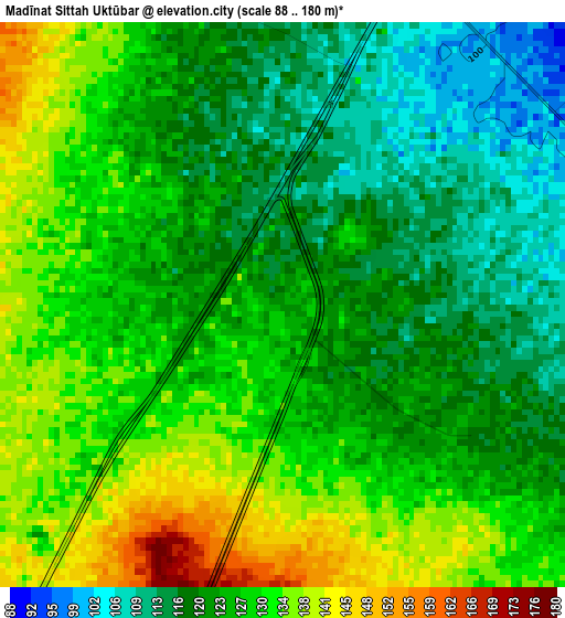
Below is the Elevation map of Madīnat Sittah Uktūbar, which displays elevation range with different colors. Scale of the first map is from 88 to 180 m (289 to 591 ft) with average elevation of 125.4 meters (=411 ft) [note 1]
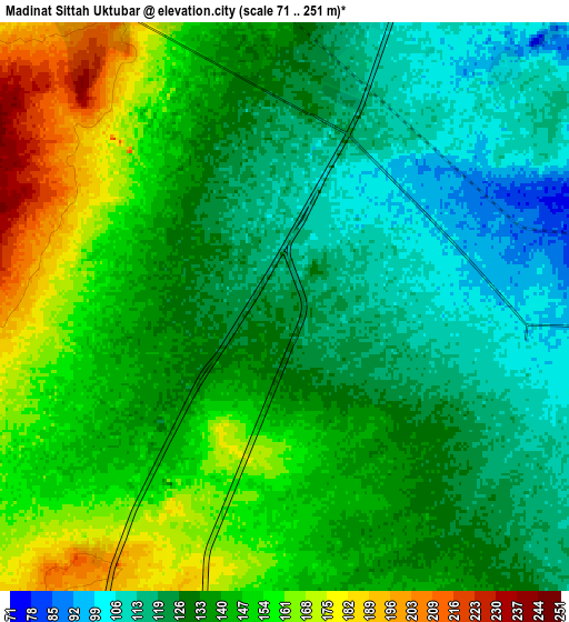
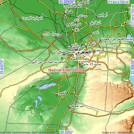
These maps also provides idea of topography and contour of this city, they are displayed at different zoom levels. More info about maps, scale and edge coordinates you can find below images.
| \ | Map #1 | Map #2 | Topo.Map |
| Scale [m] | 88..180 m | 71..251 m | × |
| Scale [ft] | 289..591 ft | 233..823 ft | × |
| Average | 125.4 m = 411 ft | 138.1 m = 453 ft | × |
| Width | 8.48 km = 5.3 mi | 16.96 km = 10.5 mi | 271.3 km = 168.6 mi |
| Height | 8.48 km = 5.3 mi | 16.96 km = 10.5 mi | 271.3 km = 168.6 mi |
| ↑Max Latitude | 29.854791° | 29.892897° | 31.02926° |
| Latitude at center | 29.81667° | 29.81667° | 29.81667° |
| ↓Min Latitude | 29.778535° | 29.740385° | 28.5892° |
| ← Min Longitude | 31.006055° | 30.962109° | 29.64375° |
| Longitude center | 31.05° | 31.05° | 31.05° |
| →Max Longitude | 31.093945° | 31.137891° | 32.45625° |
Nearby cities:
Cities around Madīnat Sittah Uktūbar sort by population:
• Cairo elevation 23 m
33.4 km,  35°
35°
• Giza 30 m
26.3 km, 36°
• Ḩalwān 28 m
24.4 km,  83°
83°
• New Cairo 271 m
46.9 km,  59°
59°
• Al Ḩawāmidīyah 23 m
21.4 km, 64°
• Qalyūb 22 m
43 km,  20°
20°
• Awsīm 25 m
35.1 km,  13°
13°
• Al Khānkah 19 m
53.4 km,  34°
34°
• Al Qanāţir al Khayrīyah 20 m
42.7 km, 11°
• Ţāmiyah -6 m
38.8 km,  192°
192°
• Aş Şaff 27 m
35.8 km,  141°
141°
• Al ‘Ayyāţ 25 m
29.7 km, 137°
Multilingual:
 En español:
Madīnat Sittah Uktūbar elevación 126 m.
 En France:
Madīnat Sittah Uktūbar élévation 126 m.
 Auf Deutsch:
Madīnat Sittah Uktūbar höhe über dem Meeresspiegel ist 126 m.
 На русском:
Madīnat Sittah Uktūbar высота над уровнем моря 126 м
Sources and notes:
- [note 1] Map square and city borders are not equal. Map elevation data is calculated only from area inside that square.
- [src 1] Elevation data from geonames database provided with same terms of usage.
- [src 2] The elevation map of Madīnat Sittah Uktūbar is generated using elevation data from NASA's 3 arcsec (90m) resolution SRTM data.
- [src 3] Base (background) map © OpenStreetMap contributors tiles are generated by Geofabrik and OpenTopoMap.
Copyright & License:
This Madīnat Sittah Uktūbar Elevation Map is licensed under CC BY-SA. You may reuse any part from this page, if you give a proper credit by linking to this URL:
 More info on terms of use page.