Colimes elevation
Colimes (Guayas, Canton Colimes), Ecuador elevation is 25 meters and Colimes elevation in feet is 82 ft above sea level [src 1]. Colimes is a populated place (feature code) with elevation that is 920 meters (3018 ft) smaller than average city elevation in Ecuador.
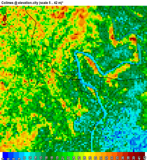
Below is the Elevation map of Colimes, which displays elevation range with different colors. Scale of the first map is from 5 to 42 m (16 to 138 ft) with average elevation of 20.5 meters (=67 ft) [note 1]
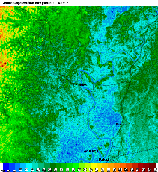
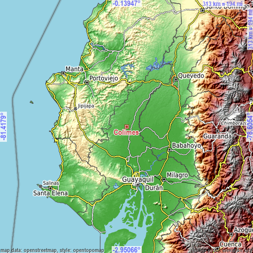
These maps also provides idea of topography and contour of this city, they are displayed at different zoom levels. More info about maps, scale and edge coordinates you can find below images.
| \ | Map #1 | Map #2 | Topo.Map |
| Scale [m] | 5..42 m | 2..80 m | × |
| Scale [ft] | 16..138 ft | 7..262 ft | × |
| Average | 20.5 m = 67 ft | 24.7 m = 81 ft | × |
| Width | 9.77 km = 6.1 mi | 19.54 km = 12.1 mi | 312.6 km = 194.2 mi |
| Height | 9.77 km = 6.1 mi | 19.54 km = 12.1 mi | 312.6 km = 194.2 mi |
| ↑Max Latitude | -1.5016° | -1.45767° | -0.13947° |
| Latitude at center | -1.54553° | -1.54553° | -1.54553° |
| ↓Min Latitude | -1.589459° | -1.633387° | -2.95066° |
| ← Min Longitude | -80.055595° | -80.099541° | -81.4179° |
| Longitude center | -80.01165° | -80.01165° | -80.01165° |
| →Max Longitude | -79.967705° | -79.923759° | -78.6054° |
Nearby cities:
Cities around Colimes sort by population:
• Babahoyo elevation 10 m
60.2 km,  118°
118°
• Balzar 41 m
23.3 km,  30°
30°
• Vinces 17 m
28.9 km,  92°
92°
• El Triunfo 6 m
43.4 km,  173°
173°
• Samborondón 9 m
56.3 km,  145°
145°
• Pedro Carbo 56 m
38.8 km,  219°
219°
• Sucre 121 m
54.1 km,  303°
303°
• Santa Ana 61 m
54.9 km,  313°
313°
• Palestina 9 m
54.7 km,  142°
142°
• Paján 125 m
46.5 km,  269°
269°
• Palenque 31 m
30.8 km,  67°
67°
• Lomas de Sargentillo 21 m
38.4 km,  191°
191°
Multilingual:
 En español:
Colimes elevación 25 m.
 En France:
Colimes élévation 25 m.


Sources and notes:
- [note 1] Map square and city borders are not equal. Map elevation data is calculated only from area inside that square.
- [src 1] Elevation data from geonames database provided with same terms of usage.
- [src 2] The elevation map of Colimes is generated using elevation data from NASA's 3 arcsec (90m) resolution SRTM data.
- [src 3] Base (background) map © OpenStreetMap contributors tiles are generated by Geofabrik and OpenTopoMap.
Copyright & License:
This Colimes Elevation Map is licensed under CC BY-SA. You may reuse any part from this page, if you give a proper credit by linking to this URL:
 More info on terms of use page.