Samborondón elevation
Samborondón (Guayas, Cantón Samborondón), Ecuador elevation is 9 meters and Samborondón elevation in feet is 30 ft above sea level [src 1]. Samborondón is a populated place (feature code) with elevation that is 936 meters (3071 ft) smaller than average city elevation in Ecuador.
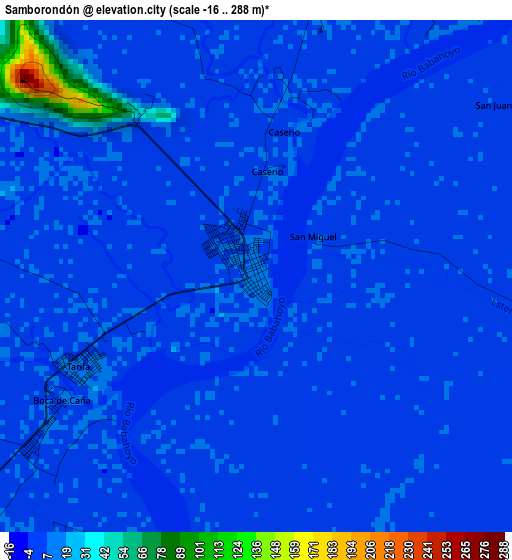
Below is the Elevation map of Samborondón, which displays elevation range with different colors. Scale of the first map is from -16 to 288 m (-52 to 945 ft) with average elevation of 9.3 meters (=31 ft) [note 1]
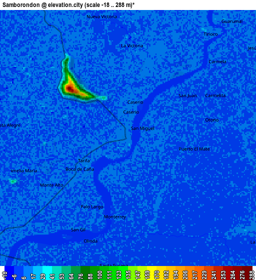
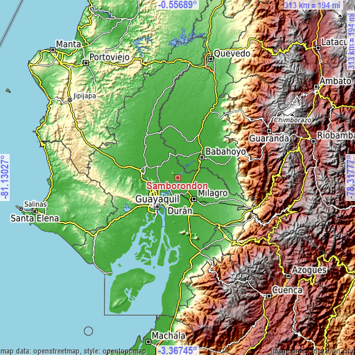
These maps also provides idea of topography and contour of this city, they are displayed at different zoom levels. More info about maps, scale and edge coordinates you can find below images.
| \ | Map #1 | Map #2 | Topo.Map |
| Scale [m] | -16..288 m | -18..288 m | × |
| Scale [ft] | -52..945 ft | -59..945 ft | × |
| Average | 9.3 m = 31 ft | 6.4 m = 21 ft | × |
| Width | 9.77 km = 6.1 mi | 19.53 km = 12.1 mi | 312.5 km = 194.2 mi |
| Height | 9.77 km = 6.1 mi | 19.53 km = 12.1 mi | 312.5 km = 194.2 mi |
| ↑Max Latitude | -1.91884° | -1.874919° | -0.55689° |
| Latitude at center | -1.96276° | -1.96276° | -1.96276° |
| ↓Min Latitude | -2.006679° | -2.050597° | -3.36745° |
| ← Min Longitude | -79.767965° | -79.811911° | -81.13027° |
| Longitude center | -79.72402° | -79.72402° | -79.72402° |
| →Max Longitude | -79.680075° | -79.636129° | -78.31777° |
Nearby cities:
Cities around Samborondón sort by population:
• Guayaquil elevation 1 m
31.6 km,  214°
214°
• Eloy Alfaro 7 m
27.8 km, 211°
• Milagro 14 m
23.9 km,  142°
142°
• Babahoyo 10 m
27.6 km,  49°
49°
• Naranjito 28 m
36.6 km,  128°
128°
• El Triunfo 6 m
27.2 km,  276°
276°
• Yaguachi Nuevo 12 m
15.3 km,  167°
167°
• Alfredo Baquerizo Moreno 9 m
23.6 km,  77°
77°
• Santa Lucía 15 m
39.3 km,  231°
231°
• Palestina 9 m
3.1 km,  21°
21°
• Lomas de Sargentillo 21 m
40.9 km, 282°
• Coronel Marcelino Maridueña 43 m
42.4 km, 130°
Multilingual:
 En español:
Samborondón elevación 9 m.
 En France:
Samborondón élévation 9 m.
 Auf Deutsch:
Samborondón höhe über dem Meeresspiegel ist 9 m.

Sources and notes:
- [note 1] Map square and city borders are not equal. Map elevation data is calculated only from area inside that square.
- [src 1] Elevation data from geonames database provided with same terms of usage.
- [src 2] The elevation map of Samborondón is generated using elevation data from NASA's 3 arcsec (90m) resolution SRTM data.
- [src 3] Base (background) map © OpenStreetMap contributors tiles are generated by Geofabrik and OpenTopoMap.
Copyright & License:
This Samborondón Elevation Map is licensed under CC BY-SA. You may reuse any part from this page, if you give a proper credit by linking to this URL:
 More info on terms of use page.