Cube elevation
Cube (Esmeraldas, Cantón Quinindé), Ecuador elevation is 138 meters and Cube elevation in feet is 453 ft above sea level [src 1]. Cube is a seat of a third-order administrative division (feature code) with elevation that is 807 meters (2648 ft) smaller than average city elevation in Ecuador.
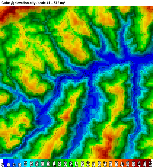
Below is the Elevation map of Cube, which displays elevation range with different colors. Scale of the first map is from 41 to 512 m (135 to 1680 ft) with average elevation of 217.1 meters (=712 ft) [note 1]
These maps also provides idea of topography and contour of this city, they are displayed at different zoom levels. More info about maps, scale and edge coordinates you can find below images.
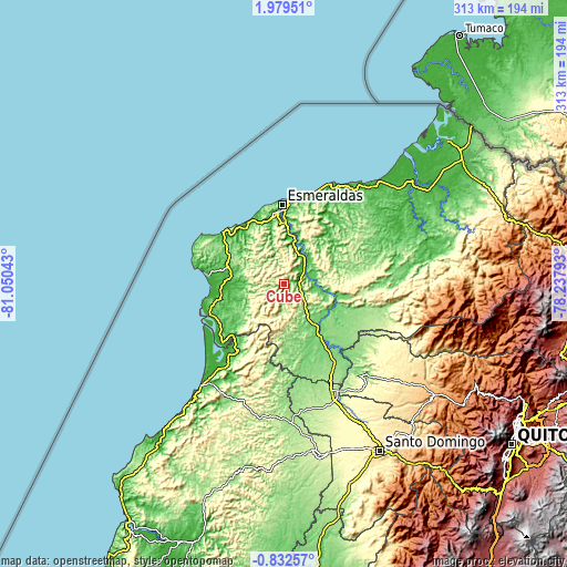
| \ | Map #1 | Topo.Map |
| Scale [m] | 41..512 m | × |
| Scale [ft] | 135..1680 ft | × |
| Average | 217.1 m = 712 ft | × |
| Width | 9.77 km = 6.1 mi | 312.7 km = 194.3 mi |
| Height | 9.77 km = 6.1 mi | 312.7 km = 194.3 mi |
| ↑Max Latitude | 0.617583° | 1.97951° |
| Latitude at center | 0.57364° | 0.57364° |
| ↓Min Latitude | 0.529697° | -0.83257° |
| ← Min Longitude | -79.688125° | -81.05043° |
| Longitude center | -79.64418° | -79.64418° |
| →Max Longitude | -79.600235° | -78.23793° |
Nearby cities:
Cities around Cube sort by population:
• Quito elevation 2854 m
153.2 km,  125°
125°
• Santo Domingo de los Colorados 554 m
105.7 km,  150°
150°
• Esmeraldas 18 m
42.9 km,  358°
358°
• Tutamandahostel 2804 m
153.6 km,  123°
123°
• Chone 16 m
150 km,  199°
199°
• Rosa Zarate 88 m
33.2 km, 145°
• San Lorenzo de Esmeraldas 14 m
119.9 km,  48°
48°
• Muisne 4 m
41.8 km,  275°
275°
• Valdez 7 m
105.1 km,  44°
44°
• Pedernales 32 m
71.9 km,  219°
219°
• Pampanal de Bolívar 7 m
120.3 km, 43°
• Wilfrido Loor Moreira 164 m
103 km,  180°
180°
Multilingual:
 En español:
Cube elevación 138 m.
 En France:
Cube élévation 138 m.


Sources and notes:
- [note 1] Map square and city borders are not equal. Map elevation data is calculated only from area inside that square.
- [src 1] Elevation data from geonames database provided with same terms of usage.
- [src 2] The elevation map of Cube is generated using elevation data from NASA's 3 arcsec (90m) resolution SRTM data.
- [src 3] Base (background) map © OpenStreetMap contributors tiles are generated by Geofabrik and OpenTopoMap.
Copyright & License:
This Cube Elevation Map is licensed under CC BY-SA. You may reuse any part from this page, if you give a proper credit by linking to this URL:
 More info on terms of use page.