Beni Amrane elevation
Beni Amrane (Boumerdes), Algeria elevation is 129 meters and Beni Amrane elevation in feet is 423 ft above sea level [src 1]. Beni Amrane is a populated place (feature code) with elevation that is 309 meters (1014 ft) smaller than average city elevation in Algeria.
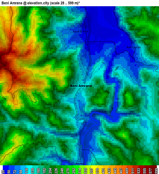
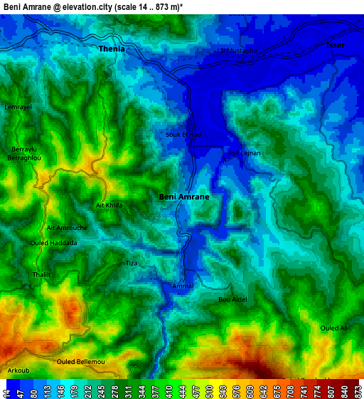
Below is the Elevation map of Beni Amrane, which displays elevation range with different colors. Scale of the first map is from 28 to 599 m (92 to 1965 ft) with average elevation of 195.5 meters (=641 ft) [note 1]
These maps also provides idea of topography and contour of this city, they are displayed at different zoom levels. More info about maps, scale and edge coordinates you can find below images.
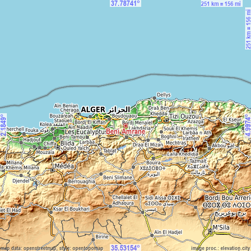
| \ | Map #1 | Map #2 | Topo.Map |
| Scale [m] | 28..599 m | 14..873 m | × |
| Scale [ft] | 92..1965 ft | 46..2864 ft | × |
| Average | 195.5 m = 641 ft | 261.1 m = 857 ft | × |
| Width | 7.84 km = 4.9 mi | 15.68 km = 9.7 mi | 250.8 km = 155.8 mi |
| Height | 7.84 km = 4.9 mi | 15.68 km = 9.7 mi | 250.8 km = 155.8 mi |
| ↑Max Latitude | 36.702981° | 36.738206° | 37.78741° |
| Latitude at center | 36.66774° | 36.66774° | 36.66774° |
| ↓Min Latitude | 36.632483° | 36.59721° | 35.53154° |
| ← Min Longitude | 3.547205° | 3.503259° | 2.1849° |
| Longitude center | 3.59115° | 3.59115° | 3.59115° |
| →Max Longitude | 3.635095° | 3.679041° | 4.9974° |
Nearby cities:
Cities around Beni Amrane sort by population:
• Boumerdas elevation 5 m
15 km,  317°
317°
• Lakhdaria 171 m
11.5 km,  179°
179°
• Reghaïa 14 m
23.6 km,  288°
288°
• Khemis el Khechna 91 m
23.3 km,  265°
265°
• Boudouaou 17 m
17.5 km, 292°
• Draa el Mizan 410 m
26.1 km,  124°
124°
• Tizi Gheniff 370 m
18.6 km, 118°
• Chabet el Ameur 245 m
9.8 km,  110°
110°
• Arbatache 150 m
19.9 km,  260°
260°
• Thenia 148 m
7.1 km,  334°
334°
• Naciria 169 m
23.1 km,  67°
67°
• Ouled Moussa 115 m
20.1 km,  275°
275°
Multilingual:
 En español:
Beni Amrane elevación 129 m.
 En France:
Beni Amrane élévation 129 m.
 Auf Deutsch:
Beni Amrane höhe über dem Meeresspiegel ist 129 m.

Sources and notes:
- [note 1] Map square and city borders are not equal. Map elevation data is calculated only from area inside that square.
- [src 1] Elevation data from geonames database provided with same terms of usage.
- [src 2] The elevation map of Beni Amrane is generated using elevation data from NASA's 3 arcsec (90m) resolution SRTM data.
- [src 3] Base (background) map © OpenStreetMap contributors tiles are generated by Geofabrik and OpenTopoMap.
Copyright & License:
This Beni Amrane Elevation Map is licensed under CC BY-SA. You may reuse any part from this page, if you give a proper credit by linking to this URL:
 More info on terms of use page.