Boumerdas elevation
Boumerdas (Boumerdes), Algeria elevation is 5 meters and Boumerdas elevation in feet is 16 ft above sea level [src 1]. Boumerdas is a seat of a first-order administrative division (feature code) with elevation that is 433 meters (1421 ft) smaller than average city elevation in Algeria.
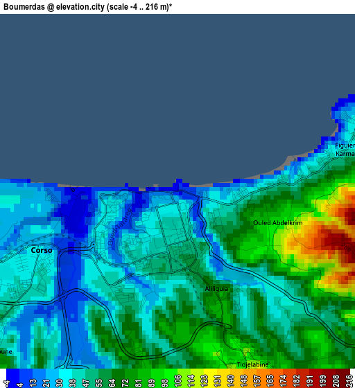
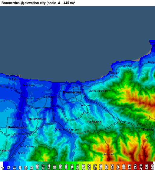
Below is the Elevation map of Boumerdas, which displays elevation range with different colors. Scale of the first map is from -4 to 216 m (-13 to 709 ft) with average elevation of 54 meters (=177 ft) [note 1]
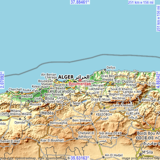
These maps also provides idea of topography and contour of this city, they are displayed at different zoom levels. More info about maps, scale and edge coordinates you can find below images.
| \ | Map #1 | Map #2 | Topo.Map |
| Scale [m] | -4..216 m | -4..445 m | × |
| Scale [ft] | -13..709 ft | -13..1460 ft | × |
| Average | 54 m = 177 ft | 109.2 m = 358 ft | × |
| Width | 7.83 km = 4.9 mi | 15.66 km = 9.7 mi | 250.5 km = 155.7 mi |
| Height | 7.83 km = 4.9 mi | 15.66 km = 9.7 mi | 250.5 km = 155.7 mi |
| ↑Max Latitude | 36.801586° | 36.836765° | 37.88461° |
| Latitude at center | 36.76639° | 36.76639° | 36.76639° |
| ↓Min Latitude | 36.731178° | 36.69595° | 35.63163° |
| ← Min Longitude | 3.433225° | 3.389279° | 2.07092° |
| Longitude center | 3.47717° | 3.47717° | 3.47717° |
| →Max Longitude | 3.521115° | 3.565061° | 4.88342° |
Nearby cities:
Cities around Boumerdas sort by population:
• Lakhdaria elevation 171 m
24.7 km,  155°
155°
• Reghaïa 14 m
12.7 km,  254°
254°
• Khemis el Khechna 91 m
18.4 km,  225°
225°
• Boudouaou 17 m
7.4 km, 234°
• Dar el Beïda 17 m
24.3 km,  255°
255°
• Aïn Taya 26 m
17.2 km,  280°
280°
• Rouiba 16 m
17.8 km, 259°
• Chabet el Ameur 245 m
24.1 km,  126°
126°
• Beni Amrane 129 m
15 km,  137°
137°
• Arbatache 150 m
17.1 km,  213°
213°
• Thenia 148 m
8.4 km,  122°
122°
• Ouled Moussa 115 m
13.5 km, 227°
Multilingual:
 En español:
Boumerdas elevación 5 m.
 En France:
Boumerdas élévation 5 m.


Sources and notes:
- [note 1] Map square and city borders are not equal. Map elevation data is calculated only from area inside that square.
- [src 1] Elevation data from geonames database provided with same terms of usage.
- [src 2] The elevation map of Boumerdas is generated using elevation data from NASA's 3 arcsec (90m) resolution SRTM data.
- [src 3] Base (background) map © OpenStreetMap contributors tiles are generated by Geofabrik and OpenTopoMap.
Copyright & License:
This Boumerdas Elevation Map is licensed under CC BY-SA. You may reuse any part from this page, if you give a proper credit by linking to this URL:
 More info on terms of use page.