Timizart elevation
Timizart (Tizi Ouzou), Algeria elevation is 312 meters and Timizart elevation in feet is 1024 ft above sea level [src 1]. Timizart is a populated place (feature code) with elevation that is 126 meters (413 ft) smaller than average city elevation in Algeria.
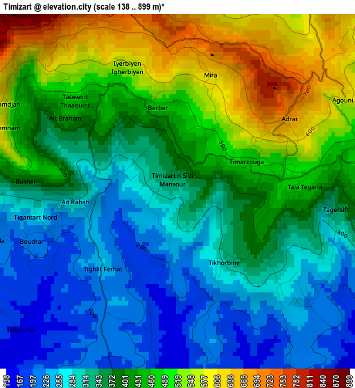
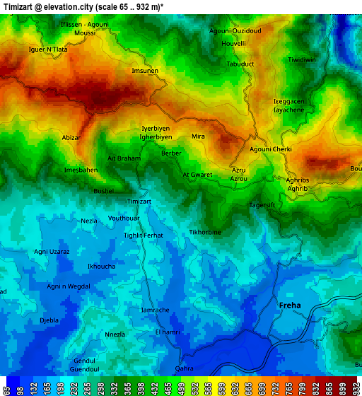
Below is the Elevation map of Timizart, which displays elevation range with different colors. Scale of the first map is from 138 to 899 m (453 to 2949 ft) with average elevation of 386.7 meters (=1269 ft) [note 1]
These maps also provides idea of topography and contour of this city, they are displayed at different zoom levels. More info about maps, scale and edge coordinates you can find below images.
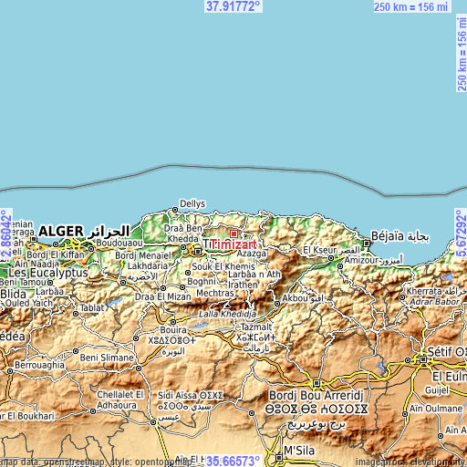
| \ | Map #1 | Map #2 | Topo.Map |
| Scale [m] | 138..899 m | 65..932 m | × |
| Scale [ft] | 453..2949 ft | 213..3058 ft | × |
| Average | 386.7 m = 1269 ft | 370.6 m = 1216 ft | × |
| Width | 7.83 km = 4.9 mi | 15.65 km = 9.7 mi | 250.4 km = 155.6 mi |
| Height | 7.83 km = 4.9 mi | 15.65 km = 9.7 mi | 250.4 km = 155.6 mi |
| ↑Max Latitude | 36.83518° | 36.870344° | 37.91772° |
| Latitude at center | 36.8° | 36.8° | 36.8° |
| ↓Min Latitude | 36.764804° | 36.729591° | 35.66573° |
| ← Min Longitude | 4.222725° | 4.178779° | 2.86042° |
| Longitude center | 4.26667° | 4.26667° | 4.26667° |
| →Max Longitude | 4.310615° | 4.354561° | 5.67292° |
Nearby cities:
Cities around Timizart sort by population:
• Tizi Ouzou elevation 206 m
22 km,  243°
243°
• Azazga 435 m
11.2 km,  123°
123°
• Makouda 310 m
18.2 km,  264°
264°
• Beni Douala 804 m
25.9 km,  219°
219°
• Freha 170 m
6.9 km,  140°
140°
• L’Arbaa Naït Irathen 710 m
19.7 km,  197°
197°
• Mekla 325 m
13.1 km,  181°
181°
• ’Aïn el Hammam 841 m
26.4 km,  172°
172°
• Arhribs 375 m
4.1 km,  100°
100°
• Boudjima 295 m
10.2 km,  271°
271°
• Tizi Rached 405 m
15.7 km,  205°
205°
• Ait Yahia 1023 m
24.2 km, 165°
Multilingual:
 En español:
Timizart elevación 312 m.
 En France:
Timizart élévation 312 m.
 Auf Deutsch:
Timizart höhe über dem Meeresspiegel ist 312 m.

Sources and notes:
- [note 1] Map square and city borders are not equal. Map elevation data is calculated only from area inside that square.
- [src 1] Elevation data from geonames database provided with same terms of usage.
- [src 2] The elevation map of Timizart is generated using elevation data from NASA's 3 arcsec (90m) resolution SRTM data.
- [src 3] Base (background) map © OpenStreetMap contributors tiles are generated by Geofabrik and OpenTopoMap.
Copyright & License:
This Timizart Elevation Map is licensed under CC BY-SA. You may reuse any part from this page, if you give a proper credit by linking to this URL:
 More info on terms of use page.