Bonao elevation
Bonao (Monseñor Nouel), Dominican Republic elevation is 177 meters and Bonao elevation in feet is 581 ft above sea level [src 1]. Bonao is a seat of a first-order administrative division (feature code) with elevation that is 14 meters (46 ft) bigger than average city elevation in Dominican Republic.
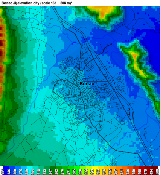
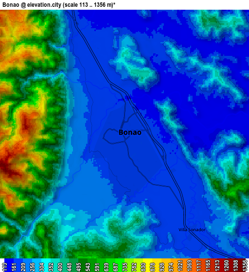
Below is the Elevation map of Bonao, which displays elevation range with different colors. Scale of the first map is from 131 to 508 m (430 to 1667 ft) with average elevation of 198.8 meters (=652 ft) [note 1]
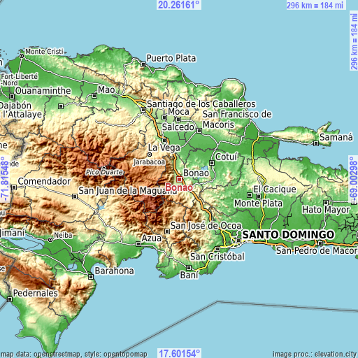
These maps also provides idea of topography and contour of this city, they are displayed at different zoom levels. More info about maps, scale and edge coordinates you can find below images.
| \ | Map #1 | Map #2 | Topo.Map |
| Scale [m] | 131..508 m | 113..1356 m | × |
| Scale [ft] | 430..1667 ft | 371..4449 ft | × |
| Average | 198.8 m = 652 ft | 338.4 m = 1110 ft | × |
| Width | 9.24 km = 5.7 mi | 18.49 km = 11.5 mi | 295.8 km = 183.8 mi |
| Height | 9.24 km = 5.7 mi | 18.49 km = 11.5 mi | 295.8 km = 183.8 mi |
| ↑Max Latitude | 18.978432° | 19.019983° | 20.26161° |
| Latitude at center | 18.93687° | 18.93687° | 18.93687° |
| ↓Min Latitude | 18.895298° | 18.853716° | 17.60154° |
| ← Min Longitude | -70.453175° | -70.497121° | -71.81548° |
| Longitude center | -70.40923° | -70.40923° | -70.40923° |
| →Max Longitude | -70.365285° | -70.321339° | -69.00298° |
Nearby cities:
Cities around Bonao sort by population:
• Concepción de La Vega elevation 101 m
34.1 km,  338°
338°
• Cotuí 67 m
30.2 km,  64°
64°
• Jarabacoa 552 m
31.1 km,  310°
310°
• Constanza 1177 m
35.4 km,  265°
265°
• Fantino 56 m
23.5 km,  29°
29°
• Piedra Blanca 180 m
14.2 km,  136°
136°
• Jima Abajo 69 m
22.1 km,  9°
9°
• Rincón 88 m
20.3 km,  0°
0°
• Tireo Arriba 1242 m
29.4 km, 269°
• Juan Adrián 356 m
20.7 km,  158°
158°
• Sabana del Puerto 118 m
14.5 km,  356°
356°
• Villa La Mata 355 m
17.4 km, 59°
Multilingual:
 En español:
Bonao elevación 177 m.
 En France:
Bonao élévation 177 m.


Sources and notes:
- [note 1] Map square and city borders are not equal. Map elevation data is calculated only from area inside that square.
- [src 1] Elevation data from geonames database provided with same terms of usage.
- [src 2] The elevation map of Bonao is generated using elevation data from NASA's 3 arcsec (90m) resolution SRTM data.
- [src 3] Base (background) map © OpenStreetMap contributors tiles are generated by Geofabrik and OpenTopoMap.
Copyright & License:
This Bonao Elevation Map is licensed under CC BY-SA. You may reuse any part from this page, if you give a proper credit by linking to this URL:
 More info on terms of use page.