El Pino elevation
El Pino (Dajabón), Dominican Republic elevation is 216 meters and El Pino elevation in feet is 709 ft above sea level [src 1]. El Pino is a populated place (feature code) with elevation that is 53 meters (174 ft) bigger than average city elevation in Dominican Republic.
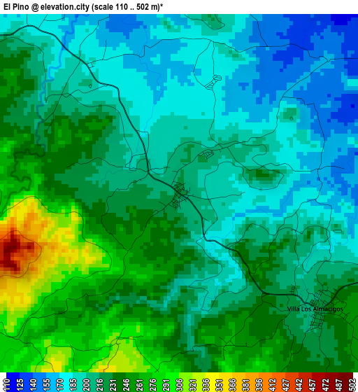
Below is the Elevation map of El Pino, which displays elevation range with different colors. Scale of the first map is from 110 to 502 m (361 to 1647 ft) with average elevation of 220.1 meters (=722 ft) [note 1]
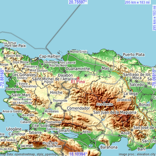
These maps also provides idea of topography and contour of this city, they are displayed at different zoom levels. More info about maps, scale and edge coordinates you can find below images.
| \ | Map #1 | Topo.Map |
| Scale [m] | 110..502 m | × |
| Scale [ft] | 361..1647 ft | × |
| Average | 220.1 m = 722 ft | × |
| Width | 9.22 km = 5.7 mi | 294.9 km = 183.2 mi |
| Height | 9.22 km = 5.7 mi | 294.9 km = 183.2 mi |
| ↑Max Latitude | 19.476806° | 20.75597° |
| Latitude at center | 19.43537° | 19.43537° |
| ↓Min Latitude | 19.393924° | 18.10394° |
| ← Min Longitude | -71.519345° | -72.88165° |
| Longitude center | -71.4754° | -71.4754° |
| →Max Longitude | -71.431455° | -70.06915° |
Nearby cities:
Cities around El Pino sort by population:
• Dajabón elevation 38 m
27.5 km,  297°
297°
• Sabaneta 127 m
14.8 km,  71°
71°
• Villa Vásquez 32 m
34.1 km,  5°
5°
• Las Matas de Santa Cruz 34 m
26.4 km,  353°
353°
• Loma de Cabrera 303 m
13.1 km,  269°
269°
• Monción 372 m
34 km,  94°
94°
• Castañuelas 23 m
31.1 km,  355°
355°
• Partido 200 m
9.3 km,  305°
305°
• Restauración 583 m
26.4 km,  239°
239°
• Cana Chapetón 63 m
29.8 km,  50°
50°
• Río Limpio 771 m
21.9 km,  195°
195°
• Villa Elisa 68 m
35.2 km,  37°
37°
Multilingual:
 En español:
El Pino elevación 216 m.
 En France:
El Pino élévation 216 m.


Sources and notes:
- [note 1] Map square and city borders are not equal. Map elevation data is calculated only from area inside that square.
- [src 1] Elevation data from geonames database provided with same terms of usage.
- [src 2] The elevation map of El Pino is generated using elevation data from NASA's 3 arcsec (90m) resolution SRTM data.
- [src 3] Base (background) map © OpenStreetMap contributors tiles are generated by Geofabrik and OpenTopoMap.
Copyright & License:
This El Pino Elevation Map is licensed under CC BY-SA. You may reuse any part from this page, if you give a proper credit by linking to this URL:
 More info on terms of use page.