Miches elevation
Miches (El Seíbo), Dominican Republic elevation is 6 meters and Miches elevation in feet is 20 ft above sea level [src 1]. Miches is a populated place (feature code) with elevation that is 157 meters (515 ft) smaller than average city elevation in Dominican Republic.
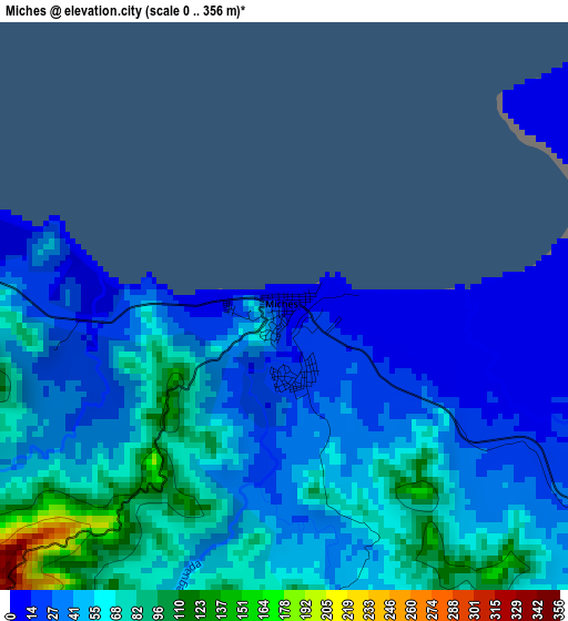
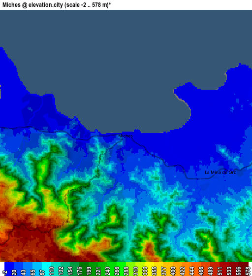
Below is the Elevation map of Miches, which displays elevation range with different colors. Scale of the first map is from 0 to 356 m (0 to 1168 ft) with average elevation of 49.1 meters (=161 ft) [note 1]
These maps also provides idea of topography and contour of this city, they are displayed at different zoom levels. More info about maps, scale and edge coordinates you can find below images.
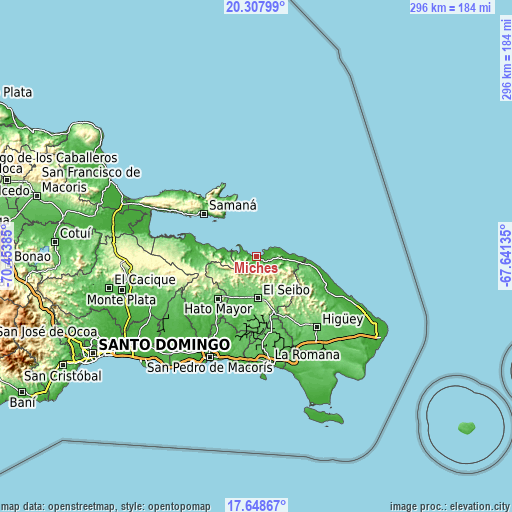
| \ | Map #1 | Map #2 | Topo.Map |
| Scale [m] | 0..356 m | -2..578 m | × |
| Scale [ft] | 0..1168 ft | -7..1896 ft | × |
| Average | 49.1 m = 161 ft | 127.3 m = 418 ft | × |
| Width | 9.24 km = 5.7 mi | 18.48 km = 11.5 mi | 295.7 km = 183.7 mi |
| Height | 9.24 km = 5.7 mi | 18.48 km = 11.5 mi | 295.7 km = 183.7 mi |
| ↑Max Latitude | 19.02519° | 19.06673° | 20.30799° |
| Latitude at center | 18.98364° | 18.98364° | 18.98364° |
| ↓Min Latitude | 18.94208° | 18.900509° | 17.64867° |
| ← Min Longitude | -69.091545° | -69.135491° | -70.45385° |
| Longitude center | -69.0476° | -69.0476° | -69.0476° |
| →Max Longitude | -69.003655° | -68.959709° | -67.64135° |
Nearby cities:
Cities around Miches sort by population:
• Salvaleón de Higüey elevation 95 m
54.4 km,  138°
138°
• Hato Mayor del Rey 106 m
33 km,  221°
221°
• Santa Cruz de El Seibo 106 m
24.3 km,  177°
177°
• Sabana de la Mar 9 m
36.8 km,  283°
283°
• Samaná 15 m
39.2 km,  309°
309°
• Guaymate 88 m
44.6 km,  170°
170°
• Otra Banda 113 m
54.9 km,  132°
132°
• El Valle 42 m
34.8 km,  268°
268°
• Guayabo Dulce 47 m
44.6 km,  213°
213°
• El Puerto 122 m
49.4 km,  243°
243°
• Ramón Santana 15 m
51 km,  195°
195°
• Pedro Sánchez 155 m
14.8 km, 205°
Multilingual:
 En español:
Miches elevación 6 m.
 En France:
Miches élévation 6 m.


Sources and notes:
- [note 1] Map square and city borders are not equal. Map elevation data is calculated only from area inside that square.
- [src 1] Elevation data from geonames database provided with same terms of usage.
- [src 2] The elevation map of Miches is generated using elevation data from NASA's 3 arcsec (90m) resolution SRTM data.
- [src 3] Base (background) map © OpenStreetMap contributors tiles are generated by Geofabrik and OpenTopoMap.
Copyright & License:
This Miches Elevation Map is licensed under CC BY-SA. You may reuse any part from this page, if you give a proper credit by linking to this URL:
 More info on terms of use page.