Samaná elevation
Samaná, Dominican Republic elevation is 15 meters and Samaná elevation in feet is 49 ft above sea level [src 1]. Samaná is a seat of a first-order administrative division (feature code) with elevation that is 148 meters (486 ft) smaller than average city elevation in Dominican Republic.
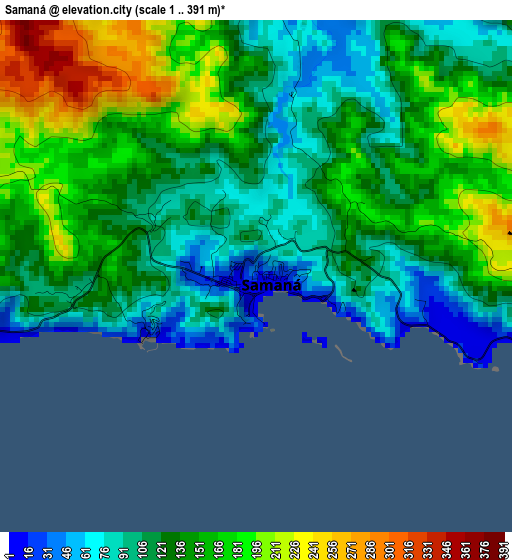
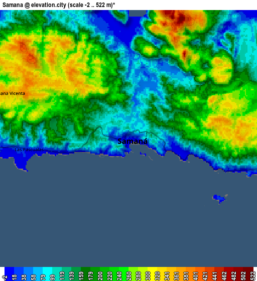
Below is the Elevation map of Samaná, which displays elevation range with different colors. Scale of the first map is from 1 to 391 m (3 to 1283 ft) with average elevation of 136.8 meters (=449 ft) [note 1]
These maps also provides idea of topography and contour of this city, they are displayed at different zoom levels. More info about maps, scale and edge coordinates you can find below images.
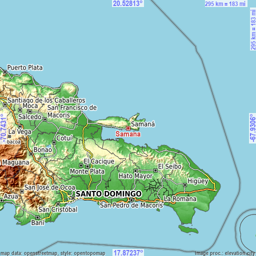
| \ | Map #1 | Map #2 | Topo.Map |
| Scale [m] | 1..391 m | -2..522 m | × |
| Scale [ft] | 3..1283 ft | -7..1713 ft | × |
| Average | 136.8 m = 449 ft | 186 m = 610 ft | × |
| Width | 9.23 km = 5.7 mi | 18.46 km = 11.5 mi | 295.3 km = 183.5 mi |
| Height | 9.23 km = 5.7 mi | 18.46 km = 11.5 mi | 295.3 km = 183.5 mi |
| ↑Max Latitude | 19.247104° | 19.288588° | 20.52813° |
| Latitude at center | 19.20561° | 19.20561° | 19.20561° |
| ↓Min Latitude | 19.164105° | 19.12259° | 17.87237° |
| ← Min Longitude | -69.380795° | -69.424741° | -70.7431° |
| Longitude center | -69.33685° | -69.33685° | -69.33685° |
| →Max Longitude | -69.292905° | -69.248959° | -67.9306° |
Nearby cities:
Cities around Samaná sort by population:
• Hato Mayor del Rey elevation 106 m
50 km,  170°
170°
• Sabana de la Mar 9 m
17.1 km,  198°
198°
• Sánchez 25 m
29.2 km,  274°
274°
• Miches 6 m
39.2 km,  129°
129°
• Las Terrenas 17 m
24.6 km,  298°
298°
• El Valle 42 m
25.9 km,  189°
189°
• El Puerto 122 m
48.9 km, 196°
• Arenoso 18 m
54.9 km, 267°
• Gonzalo 286 m
51.9 km,  237°
237°
• Agua Santa del Yuna 11 m
49.1 km,  262°
262°
• Pedro Sánchez 155 m
44.9 km,  147°
147°
• Majagual 226 m
55.5 km,  250°
250°
Multilingual:
 En español:
Samaná elevación 15 m.
 En France:
Samaná élévation 15 m.


Sources and notes:
- [note 1] Map square and city borders are not equal. Map elevation data is calculated only from area inside that square.
- [src 1] Elevation data from geonames database provided with same terms of usage.
- [src 2] The elevation map of Samaná is generated using elevation data from NASA's 3 arcsec (90m) resolution SRTM data.
- [src 3] Base (background) map © OpenStreetMap contributors tiles are generated by Geofabrik and OpenTopoMap.
Copyright & License:
This Samaná Elevation Map is licensed under CC BY-SA. You may reuse any part from this page, if you give a proper credit by linking to this URL:
 More info on terms of use page.