San Pedro de Macorís elevation
San Pedro de Macorís, Dominican Republic elevation is 6 meters and San Pedro de Macorís elevation in feet is 20 ft above sea level [src 1]. San Pedro de Macorís is a seat of a first-order administrative division (feature code) with elevation that is 157 meters (515 ft) smaller than average city elevation in Dominican Republic.
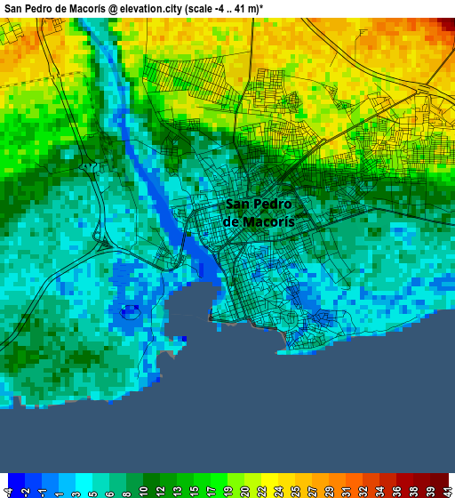
Below is the Elevation map of San Pedro de Macorís, which displays elevation range with different colors. Scale of the first map is from -4 to 41 m (-13 to 135 ft) with average elevation of 12 meters (=39 ft) [note 1]
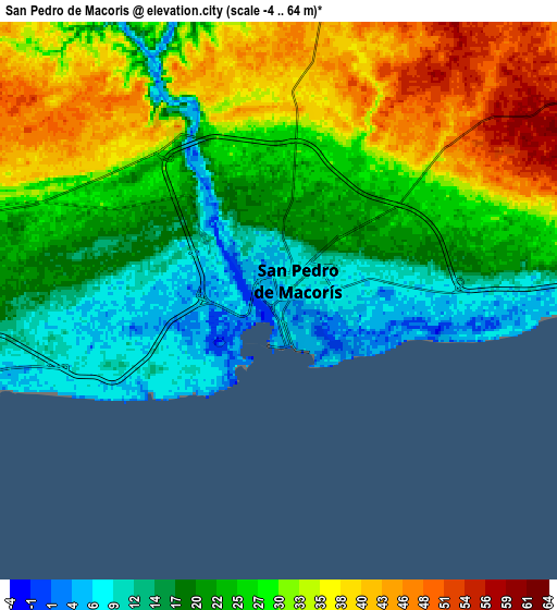
These maps also provides idea of topography and contour of this city, they are displayed at different zoom levels. More info about maps, scale and edge coordinates you can find below images.
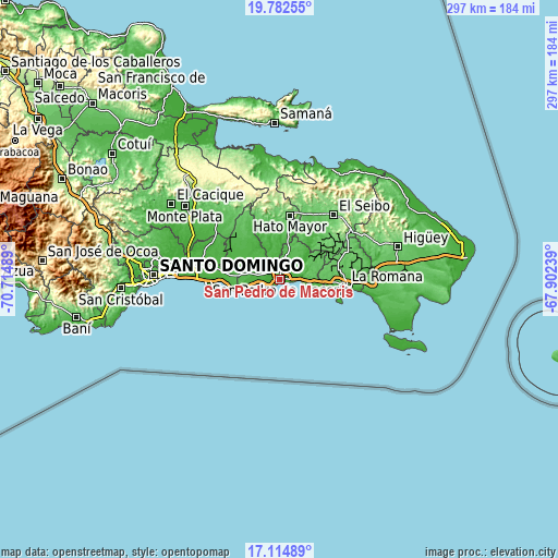
| \ | Map #1 | Map #2 | Topo.Map |
| Scale [m] | -4..41 m | -4..64 m | × |
| Scale [ft] | -13..135 ft | -13..210 ft | × |
| Average | 12 m = 39 ft | 26 m = 85 ft | × |
| Width | 9.27 km = 5.8 mi | 18.54 km = 11.5 mi | 296.6 km = 184.3 mi |
| Height | 9.27 km = 5.8 mi | 18.54 km = 11.5 mi | 296.6 km = 184.3 mi |
| ↑Max Latitude | 18.495581° | 18.537251° | 19.78255° |
| Latitude at center | 18.4539° | 18.4539° | 18.4539° |
| ↓Min Latitude | 18.412209° | 18.370509° | 17.11489° |
| ← Min Longitude | -69.352585° | -69.396531° | -70.71489° |
| Longitude center | -69.30864° | -69.30864° | -69.30864° |
| →Max Longitude | -69.264695° | -69.220749° | -67.90239° |
Nearby cities:
Cities around San Pedro de Macorís sort by population:
• La Romana elevation 30 m
35.5 km,  94°
94°
• Boca Chica 12 m
30.7 km,  269°
269°
• Hato Mayor del Rey 106 m
34.8 km,  9°
9°
• Santa Cruz de El Seibo 106 m
44.8 km,  39°
39°
• Bayaguana 59 m
47.7 km,  313°
313°
• Quisqueya 30 m
15.4 km,  317°
317°
• Guaymate 88 m
37.8 km,  66°
66°
• Los Llanos 45 m
27.1 km, 313°
• Guayabo Dulce 47 m
22 km, 6°
• El Puerto 122 m
40.2 km,  335°
335°
• Ramón Santana 15 m
16.8 km,  54°
54°
• Guerra 29 m
43 km,  285°
285°
Multilingual:
 En español:
San Pedro de Macorís elevación 6 m.
 En France:
San Pedro de Macorís élévation 6 m.
 Auf Deutsch:
San Pedro de Macorís höhe über dem Meeresspiegel ist 6 m.
 На русском:
San Pedro de Macorís высота над уровнем моря 6 м
Sources and notes:
- [note 1] Map square and city borders are not equal. Map elevation data is calculated only from area inside that square.
- [src 1] Elevation data from geonames database provided with same terms of usage.
- [src 2] The elevation map of San Pedro de Macorís is generated using elevation data from NASA's 3 arcsec (90m) resolution SRTM data.
- [src 3] Base (background) map © OpenStreetMap contributors tiles are generated by Geofabrik and OpenTopoMap.
Copyright & License:
This San Pedro de Macorís Elevation Map is licensed under CC BY-SA. You may reuse any part from this page, if you give a proper credit by linking to this URL:
 More info on terms of use page.