San Rafael del Yuma elevation
San Rafael del Yuma (La Altagracia), Dominican Republic elevation is 49 meters and San Rafael del Yuma elevation in feet is 161 ft above sea level [src 1]. San Rafael del Yuma is a populated place (feature code) with elevation that is 114 meters (374 ft) smaller than average city elevation in Dominican Republic.
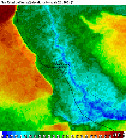
Below is the Elevation map of San Rafael del Yuma, which displays elevation range with different colors. Scale of the first map is from 32 to 108 m (105 to 354 ft) with average elevation of 64.2 meters (=211 ft) [note 1]
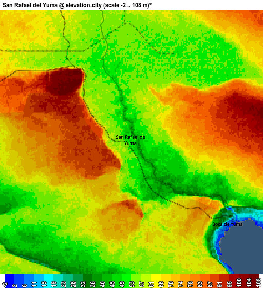
These maps also provides idea of topography and contour of this city, they are displayed at different zoom levels. More info about maps, scale and edge coordinates you can find below images.
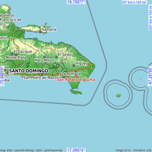
| \ | Map #1 | Map #2 | Topo.Map |
| Scale [m] | 32..108 m | -2..108 m | × |
| Scale [ft] | 105..354 ft | -7..354 ft | × |
| Average | 64.2 m = 211 ft | 63.7 m = 209 ft | × |
| Width | 9.27 km = 5.8 mi | 18.54 km = 11.5 mi | 296.7 km = 184.4 mi |
| Height | 9.27 km = 5.8 mi | 18.54 km = 11.5 mi | 296.7 km = 184.4 mi |
| ↑Max Latitude | 18.471616° | 18.513293° | 19.75877° |
| Latitude at center | 18.42993° | 18.42993° | 18.42993° |
| ↓Min Latitude | 18.388234° | 18.346527° | 17.09074° |
| ← Min Longitude | -68.717845° | -68.761791° | -70.08015° |
| Longitude center | -68.6739° | -68.6739° | -68.6739° |
| →Max Longitude | -68.629955° | -68.586009° | -67.26765° |
Nearby cities:
Cities around San Rafael del Yuma sort by population:
• San Pedro de Macorís elevation 6 m
67 km,  272°
272°
• La Romana 30 m
31.5 km, 269°
• Salvaleón de Higüey 95 m
20.9 km,  350°
350°
• Punta Cana 28 m
33.1 km,  59°
59°
• Hato Mayor del Rey 106 m
71.7 km,  301°
301°
• Santa Cruz de El Seibo 106 m
53.6 km,  314°
314°
• Guaymate 88 m
36.6 km, 298°
• Otra Banda 113 m
24.5 km,  2°
2°
• Guayabo Dulce 47 m
68.7 km,  290°
290°
• Ramón Santana 15 m
54.8 km,  283°
283°
• Boca de Yuma 8 m
8.9 km,  130°
130°
• Pedro Sánchez 155 m
66.5 km,  316°
316°
Multilingual:
 En español:
San Rafael del Yuma elevación 49 m.
 En France:
San Rafael del Yuma élévation 49 m.
 Auf Deutsch:
San Rafael del Yuma höhe über dem Meeresspiegel ist 49 m.
 На русском:
San Rafael del Yuma высота над уровнем моря 49 м
Sources and notes:
- [note 1] Map square and city borders are not equal. Map elevation data is calculated only from area inside that square.
- [src 1] Elevation data from geonames database provided with same terms of usage.
- [src 2] The elevation map of San Rafael del Yuma is generated using elevation data from NASA's 3 arcsec (90m) resolution SRTM data.
- [src 3] Base (background) map © OpenStreetMap contributors tiles are generated by Geofabrik and OpenTopoMap.
Copyright & License:
This San Rafael del Yuma Elevation Map is licensed under CC BY-SA. You may reuse any part from this page, if you give a proper credit by linking to this URL:
 More info on terms of use page.