Villa Altagracia elevation
Villa Altagracia (San Cristóbal), Dominican Republic elevation is 178 meters and Villa Altagracia elevation in feet is 584 ft above sea level [src 1]. Villa Altagracia is a populated place (feature code) with elevation that is 15 meters (49 ft) bigger than average city elevation in Dominican Republic.
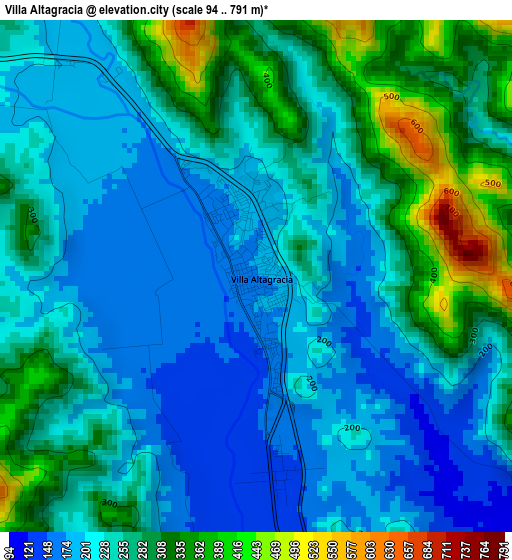
Below is the Elevation map of Villa Altagracia, which displays elevation range with different colors. Scale of the first map is from 94 to 791 m (308 to 2595 ft) with average elevation of 246 meters (=807 ft) [note 1]
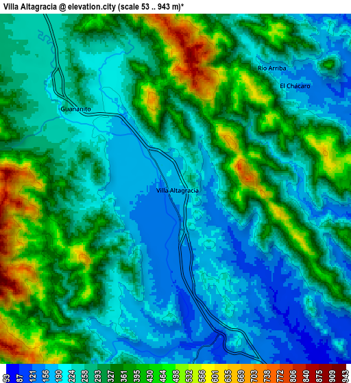
These maps also provides idea of topography and contour of this city, they are displayed at different zoom levels. More info about maps, scale and edge coordinates you can find below images.
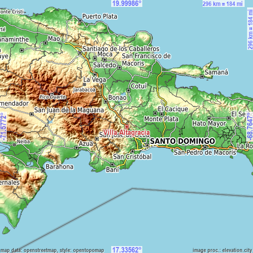
| \ | Map #1 | Map #2 | Topo.Map |
| Scale [m] | 94..791 m | 53..943 m | × |
| Scale [ft] | 308..2595 ft | 174..3094 ft | × |
| Average | 246 m = 807 ft | 296.7 m = 973 ft | × |
| Width | 9.26 km = 5.8 mi | 18.52 km = 11.5 mi | 296.2 km = 184 mi |
| Height | 9.26 km = 5.8 mi | 18.52 km = 11.5 mi | 296.3 km = 184.1 mi |
| ↑Max Latitude | 18.714597° | 18.756214° | 19.99986° |
| Latitude at center | 18.67297° | 18.67297° | 18.67297° |
| ↓Min Latitude | 18.631333° | 18.589685° | 17.33562° |
| ← Min Longitude | -70.214895° | -70.258841° | -71.5772° |
| Longitude center | -70.17095° | -70.17095° | -70.17095° |
| →Max Longitude | -70.127005° | -70.083059° | -68.7647° |
Nearby cities:
Cities around Villa Altagracia sort by population:
• Santo Domingo Oeste elevation 58 m
26.4 km,  136°
136°
• San Cristóbal 33 m
29.5 km,  165°
165°
• Cambita Garabitos 184 m
24.5 km,  186°
186°
• Yamasá 89 m
18.9 km,  53°
53°
• La Agustina 31 m
31.6 km,  127°
127°
• Piedra Blanca 180 m
24.5 km,  321°
321°
• Esperalvillo 148 m
21.3 km,  42°
42°
• Los Botados 59 m
19.6 km,  70°
70°
• El Carril 60 m
29.1 km,  148°
148°
• Don Juan 59 m
29.3 km, 53°
• El Cacao 403 m
20.9 km,  219°
219°
• Juan Adrián 356 m
20.2 km,  299°
299°
Multilingual:
 En español:
Villa Altagracia elevación 178 m.
 En France:
Villa Altagracia élévation 178 m.
 Auf Deutsch:
Villa Altagracia höhe über dem Meeresspiegel ist 178 m.

Sources and notes:
- [note 1] Map square and city borders are not equal. Map elevation data is calculated only from area inside that square.
- [src 1] Elevation data from geonames database provided with same terms of usage.
- [src 2] The elevation map of Villa Altagracia is generated using elevation data from NASA's 3 arcsec (90m) resolution SRTM data.
- [src 3] Base (background) map © OpenStreetMap contributors tiles are generated by Geofabrik and OpenTopoMap.
Copyright & License:
This Villa Altagracia Elevation Map is licensed under CC BY-SA. You may reuse any part from this page, if you give a proper credit by linking to this URL:
 More info on terms of use page.